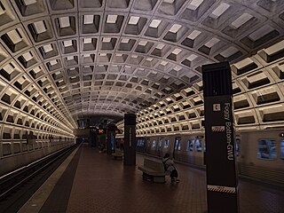
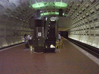
Foggy Bottom–GWU station is a Washington Metro station in the Foggy Bottom neighborhood of Washington, D.C., United States. The island-platformed station was opened on July 1, 1977, and is operated by the Washington Metropolitan Area Transit Authority (WMATA). Providing service for the Blue, Orange, and Silver Lines, the station is located on I Street on the George Washington University (GWU) campus. It is the last westbound station in the District of Columbia on these lines before they dive under the Potomac River to Virginia.
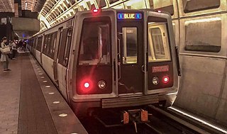
The Blue Line is a rapid transit line of the Washington Metro system, consisting of 28 stations in Fairfax County, Alexandria and Arlington, Virginia; Washington, D.C.; and Prince George's County, Maryland, United States. The Blue Line runs from Franconia–Springfield to Downtown Largo. The line shares track with the Orange Line for 13 stations, the Silver Line for 18, and the Yellow Line for 7. Only 3 stations are exclusive to the Blue Line.

The Orange Line is a rapid transit line of the Washington Metro system, consisting of 26 stations in Fairfax County and Arlington in Northern Virginia; Washington, D.C.; and Prince George's County, Maryland, United States. The Orange Line runs from Vienna in Virginia to New Carrollton in Maryland. Half of the line's stations are shared with the Blue Line and over two thirds are shared with the Silver Line. Orange Line service began on November 20, 1978.
Farragut West station is a Washington Metro station in Downtown Washington, D.C., United States. The side-platformed station was opened on July 1, 1977, and is operated by the Washington Metropolitan Area Transit Authority (WMATA). Providing service for the Blue, Orange and Silver Lines, the station is located just west of Farragut Square with two entrances on I Street at 17th and 18th Streets NW.

Federal Triangle station is a Washington Metro station in Washington, D.C., United States. The island-platformed station was opened on July 1, 1977, and is operated by the Washington Metropolitan Area Transit Authority (WMATA). Providing service for the Blue, Orange, and Silver Lines, the station's entrance is beneath the William Jefferson Clinton Federal Building.

Ronald Reagan Washington National Airport station is a Washington Metro station in Arlington, Virginia on the Blue and Yellow Lines. The station platform is elevated and covered and is the last above-ground station on the Yellow Line in Virginia, heading into Washington, D.C. It is one of only two stations in the system to have three tracks. The station is located across Smith Boulevard from Terminal 2 at Ronald Reagan Washington National Airport; the mezzanine is directly connected to Level 2 of the terminal by two pedestrian bridges. Airport shuttle buses or a walkway connect the station and Terminal 1. The airport's Abingdon Plantation historical site is near the station.
Federal Center SW station is a Washington Metro station in an area known as the Southwest Federal Center in Washington, D.C., United States. The island-platformed station was opened on July 1, 1977, and is operated by the Washington Metropolitan Area Transit Authority (WMATA) and is located on the Orange, Silver, and Blue Lines. The station is located at 3rd and D Streets.

Capitol South station is a Washington Metro station in the Capitol Hill neighborhood of Washington, D.C., United States. The island-platformed station was opened on July 1, 1977, and is operated by the Washington Metropolitan Area Transit Authority (WMATA). The station currently provides service for the Blue, Orange, and Silver Lines.

Eastern Market station is a Washington Metro station in the Capitol Hill neighborhood of Washington, D.C., United States. The island platformed station was opened on July 1, 1977, and is operated by the Washington Metropolitan Area Transit Authority (WMATA). The station currently provides service for the Blue, Orange, and Silver Lines. The station is located in Southeast D.C. at Pennsylvania Avenue and 7th Street. It is named after the nearby Eastern Market, a historic public marketplace.

Potomac Avenue station is an island-platformed Washington Metro station in the Capitol Hill neighborhood of Washington, D.C., United States. The station was opened on July 1, 1977, and is operated by the Washington Metropolitan Area Transit Authority (WMATA). The station currently provides service for the Blue, Orange, and Silver Lines. The station serves a dense residential area of Southeast Washington around Potomac Avenue and is located at 14th and G Streets.

Stadium–Armory station is a Washington Metro station in Southeast, Washington, D.C. It is located at the border of the Barney Circle and Kingman Park neighborhoods. The station was opened on July 1, 1977, and is operated by the Washington Metropolitan Area Transit Authority (WMATA). Stadium–Armory serves the Blue, Orange and Silver Lines. It is a transfer station, as this is the last station shared by the three lines before the lines diverge going east; east of the station, all three lines rise above ground onto elevated track to cross the Anacostia River. At the diverge point, the Orange Line continues above ground veering northbound towards the Minnesota Avenue station, and the Blue and Silver Lines continue eastbound entering a tunnel towards Benning Road.
Benning Road station is an island-platformed Washington Metro station in the Benning Ridge neighborhood of Northeast Washington, D.C., United States. The station was opened on November 22, 1980, and is operated by the Washington Metropolitan Area Transit Authority (WMATA). Providing service for the Blue and Silver Lines, the station is located in a residential area near the intersection of Benning Road and East Capitol Street. It is the first station after the Blue and Silver Lines diverge from the Orange Line east of the Anacostia River, and also the last station in the District of Columbia going east.
Capitol Heights station is an island-platformed Washington Metro station in Capitol Heights, Maryland, United States. The station was opened on November 22, 1980, and is operated by the Washington Metropolitan Area Transit Authority (WMATA). Providing service for the Blue and Silver Lines, the station is located at 133 Central Avenue in a residential area at East Capitol Street and Southern Avenue SE. This is the first station on the two lines in Maryland going east. As of 2017, in terms of weekday average boardings, it is the least used underground station in the system and the 10th least used station overall.

Morgan Boulevard station is an island-platformed Washington Metro station in Summerfield, Prince George's County, Maryland, United States, with a Landover postal address. The station was opened on December 18, 2004, and is operated by the Washington Metropolitan Area Transit Authority (WMATA). It provides service for the Blue and Silver Lines.

Downtown Largo station is an island-platformed Washington Metro station in Lake Arbor, Prince George's County, Maryland, United States, with a Largo postal address.

Minnesota Avenue station is an island-platformed Washington Metro station in the Central Northeast/Mahaning Heights neighborhood of Northeast Washington, D.C., United States. The station was opened on November 20, 1978, and is operated by the Washington Metropolitan Area Transit Authority (WMATA).

The Silver Line is a rapid transit line of the Washington Metro system, consisting of 34 stations in Loudoun County, Fairfax County and Arlington County, Virginia, Washington, D.C., as well as Prince George's County, Maryland. The Silver Line runs from Ashburn in Virginia to Downtown Largo in Maryland. Five stations, from both lines' eastern terminus at Downtown Largo to Benning Road, are shared with the Blue Line alone; thirteen stations, from Stadium–Armory to Rosslyn, with both the Orange Line and Blue Lines; and five stations from Court House to East Falls Church with the Orange Line alone. Only the five stations of Phase 1, which began service on July 26, 2014, and the six stations of Phase 2, which began service on November 15, 2022, are exclusive to the Silver Line.
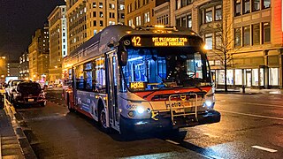
The Mount Pleasant Line, designated Routes 42 and 43, is a daily bus route in Washington, D.C., It was a streetcar line until the 1960s.

The Martin Luther King Jr. Highway Line, designated Route A12 is a daily bus route operated by the Washington Metropolitan Area Transit Authority between Addison Road station of the Blue and Silver Lines of the Washington Metro and New Carrollton station of the Orange Line of the Washington Metro. The line operates every 20 minutes between 7AM and 9PM, 30 minutes after 9PM weekdays and 60 minutes after 9PM weekends. Route A12 trips roughly take 30 minutes. On Sundays, Route A12 is extended to Capitol Heights station replacing a portion of route F14.

The East Capitol Street–Cardozo Line, designated Route 96, is a daily bus route operated by the Washington Metropolitan Area Transit Authority between Tenleytown-AU station of the Red Line of the Washington Metro and Capitol Heights station of the Blue and Silver Lines of the Washington Metro. The line operates every 20–30 minutes at all times. Route 96 trips are roughly 80 minutes long.

