
Morgantown is a city in and the county seat of Monongalia County, West Virginia, United States, situated along the Monongahela River. The largest city in North-Central West Virginia and the third-largest city in the state, Morgantown is best known as the home of West Virginia University. The population was 30,347 at the 2020 census. The city serves as the anchor of the Morgantown metropolitan area, which had a population of 138,176 in 2020.

The Blue Ridge Parkway is a National Parkway and All-American Road in the United States, noted for its scenic beauty. The parkway, which is America's longest linear park, runs for 469 miles (755 km) through 29 Virginia and North Carolina counties, linking Shenandoah National Park to Great Smoky Mountains National Park. It runs mostly along the spine of the Blue Ridge, a major mountain chain that is part of the Appalachian Mountains. Its southern terminus is at U.S. Route 441 (US 441) on the boundary between Great Smoky Mountains National Park and the Qualla Boundary of the Eastern Band of Cherokee Indians in North Carolina, from which it travels north to Shenandoah National Park in Virginia. The roadway continues through Shenandoah as Skyline Drive, a similar scenic road which is managed by a different National Park Service unit. Both Skyline Drive and the Virginia portion of the Blue Ridge Parkway are part of Virginia State Route 48 (SR 48), though this designation is not signed.

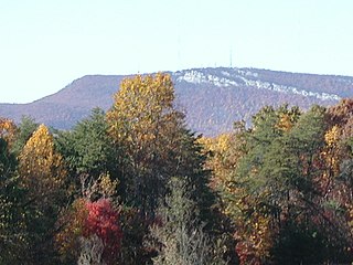
Hanging Rock State Park is a 9,011-acre (3,647 ha) North Carolina state park in Stokes County, North Carolina in the United States. The park is 30 miles (48 km) north of Winston-Salem and is located approximately 2 miles (3.2 km) from Danbury in Stokes County.

The Allegheny Front is the major southeast- or east-facing escarpment in the Allegheny Mountains in southern Pennsylvania, western Maryland, eastern West Virginia, and western Virginia, USA. The Allegheny Front forms the boundary between the Ridge-and-Valley Appalachians to its east and the Appalachian Plateau to its west. The Front is closely associated with the Appalachian Mountains' Eastern Continental Divide, which in this area divides the waters of the Ohio/Mississippi river system, flowing to the Gulf of Mexico, from rivers flowing into Chesapeake Bay and from there into the Atlantic Ocean.
Schunemunk Mountain is the highest mountain in Orange County, New York. The 1,664-foot (507 m) summit is located in the town of Blooming Grove, with other portions in Cornwall and Woodbury. The community of Mountain Lodge Park is built up its western slope.

Dick's Knob or Dicks Knob, with an elevation of 4,620 feet (1,408 m), is the third-highest peak in the State of Georgia if using a 200 ft. prominence rule. It is located in Rabun County, Georgia within the Southern Nantahala Wilderness and is the second-highest mountain in the county.

North Fork Mountain is a quartzite-capped mountain ridge in the Ridge and Valley physiographic province of the Allegheny Mountains, also known as the High Alleghenies or Potomac Highlands, of eastern West Virginia. Kile Knob, at 4,588 feet, is the mountain's highest point, and Panther Knob and Pike Knob are nearly as high.

Roan Mountain is a 6,285 ft (1,916 m) mountain straddling the North Carolina/Tennessee border in the Unaka Range of the Southern Appalachian Mountains in the Southeastern United States. The range's highpoint, Roan is clad in a dense stand of Southern Appalachian spruce-fir forest, and includes the world's largest natural rhododendron garden, and the longest stretch of grassy bald in the Appalachian range. The Roan Highlands also contain the highest quality remaining stretch of Fraser fir forest throughout the tree's entire range. The Cherokee National Forest and Pisgah National Forest converge atop the mountain, with Roan Mountain State Park located near its northern base. The Appalachian Trail traverses most of the Roan's crest. The Roan High Knob Shelter is the highest back-country shelter on the entire 2,174-mile (3,499 km) trail.

Waterrock Knob is a mountain peak in the U.S. state of North Carolina. It is the highest peak in the Plott Balsams and is the 16th-highest mountain in the Eastern United States.

Blue Knob is a summit in the eastern United States with a broad dome that is the northernmost 3,000-footer in the Allegheny Mountains. It is the highest point in Bedford County, Pennsylvania.
Old Black is a mountain in the Great Smoky Mountains, located in the Southeastern United States. While often overshadowed by Mount Guyot, its higher neighbor to the south, Old Black is the 5th-highest mountain in Tennessee and the 7th-highest in the Great Smoky Mountains National Park. The Appalachian Trail crosses its western slope, connecting the Cosby-area trail system with the heart of the Eastern Smokies.
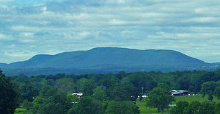
The Sauratown Mountains, which are sometimes called "the mountains away from the mountains", are an isolated mountain range located within Stokes and Surry counties in the U.S. state of North Carolina. The vast majority of the range is located in Stokes County. Although the range occupies only 5% of Stokes County's area, it dominates the county's scenery from almost every direction. The Sauras rise sharply 800 to 1,700 feet above the surrounding terrain.

Pine Mountain is a ridge in the Appalachian Mountains running through Kentucky, Virginia and Tennessee. It extends about 125 miles from near Pioneer, Tennessee, to a location near Elkhorn City, Kentucky. Birch Knob, the highest point, is 3,273 feet (998 m) above sea level and is located on the Kentucky-Virginia border. It has long been a barrier to transportation, as the Cumberland River at Pineville, Kentucky is one of only two waterways that pass through the entire ridge. The other is the Clear Fork near Jellico, Tennessee.

Mount Norwottuck or Mount Norwottock, 1,106 feet (337 m) above sea level, is the highest peak of the Holyoke Range of traprock mountains located in the Connecticut River Valley of Massachusetts and part of the greater Metacomet Ridge which stretches from Long Island Sound to nearly the Vermont border. The peak rises steeply from the valley 1,000 feet (300 m) below and offers sweeping views of the surrounding countryside. It is located within the towns of Amherst and Granby, Massachusetts.

Fort Davidson, a fortification near the town of Pilot Knob, Missouri, was the site of the Battle of Fort Davidson during the American Civil War. Built by Union Army soldiers during the American Civil War, the fort repulsed Confederate attacks during the Battle of Fort Davidson on September 27, 1864, during Price's Raid. That night, the Union garrison blew up the fort's magazine and abandoned the site. A mass grave was constructed on the site to bury battlefield dead. After the war, the area was used by a mining company, before passing into private hands and eventually the administration of the United States Forest Service. In 1968, the Battle of Pilot Knob State Historic Site was created as a Missouri State Park. The fort itself was added to the National Register of Historic Places in 1970. As of 2020, a visitors center containing a museum is located within the park. The museum contains a fiber optic display, as well as artifacts including Brigadier General Thomas Ewing Jr.'s sword. The fort's walls are still visible, as is the crater created when the magazine was detonated. A monument marks the location of the mass grave.
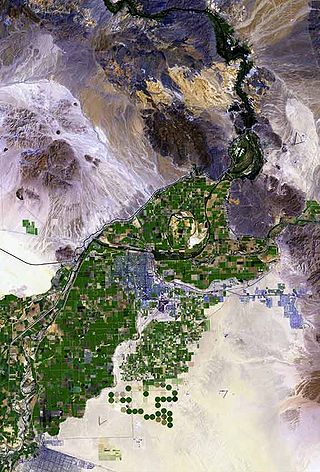
Pilot Knob is a peak in Imperial County, California. Pilot Knob is located 8 miles (13 km) southeast of Ogilby, It rises to an elevation of 876 feet (267 m). Pilot Knob is a rocky landform, geologically a Volcanic plug, west of Yuma, Arizona–Winterhaven, California; it is connected to the Cargo Muchacho Mountains, the central portion of the mountains being about 7 miles (11 km) north. Pilot Knob was named for its prominence as a landmark for riverboat traffic in the 19th-20th centuries on the Colorado River which borders Winterhaven–Yuma. Pilot Knob is an Area of Critical Environmental Concern administered by the Bureau of Land Management.

Trischman Knob el. 8,573 feet (2,613 m) is an isolated summit along the Continental Divide on the Madison Plateau in Yellowstone National Park. The summit is located approximately 1.5 miles (2.4 km) west of the Bechler River trail just south of Madison Lake, the source of the Firehole River. The summit was named in 1962 by Assistant Chief Ranger Willam S. Chapman for Harry Trischman (1886–1950). Trischman came to Yellowstone in 1899 with his parents. His father was the post carpenter at Fort Yellowstone. Trischman worked as a U.S. Army scout and in 1916 became one of the first park rangers. He worked as a ranger in Yellowstone until his retirement in 1945. Trischman Knob was one of his favorite backcountry haunts.
Douglas Knob el. 8,507 feet (2,593 m) is an isolated mountain peak in the southwest section of Yellowstone National Park. Located just east of the Littler Fork of the Bechler River at the southern extent of the Madison Plateau, Douglas Knob is named for Joseph O. Douglas. In 1962, then Assistant Chief Ranger, William S. Chapman named the summit for Douglas who was an early Park Ranger. In 1921, Douglas was the Assistant Chief Ranger as well as the park's chief Buffalo Keeper. The summit is less than .25 miles (0.40 km) east of the Bechler River trail.
Howard Knob is a mountain in the North Carolina High Country, located in the town of Boone. According to the US Geological Survey, the mountain's proper name is Howard Knob, but it is known to locals and tourists as Howard's Knob. Howard Knob and the surrounding area are part of the Appalachian Mountain Range. The mountain has an elevation of 4,396 feet (1,340 m) above sea level, and rises nearly 1,000 feet (300 m) above the town of Boone and the campus of Appalachian State University.

