The River Knobs — formerly known as East Seneca Ridge — are a ridge and series of knobs in western Pendleton County, West Virginia, USA, along a stretch of the North Fork South Branch Potomac River. Although the Knobs (peak elevation: 2,854ft) are dwarfed by Spruce Mountain to the west (peak: 4,840ft) and by North Fork Mountain to the east (peak: 4,588ft), they are notable for their series of prominent "razorback" ridges or "fins". The largest and most famous of these blade-like crags is Seneca Rocks.
Geography
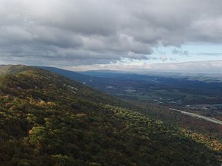
The River Knobs stretch for about 18 miles (29km) from near Cherry Grove to near Seneca Rocks and are situated in a southwest/northeast orientation. They are a minor part of the High Alleghenies of the Appalachian Mountain Range. Their rock outcrops are clearly visible from WV 55 and US 33. Each is associated with a named gap through which a stream has transected the ridge and exposed the bedrock. From north to south the most prominent features are Roy Gap (with its Seneca Rocks), Harper Knob (2,820ft), Harper Gap, Harmon Knob (2,854ft), Hinkle Gap, Germany Knob (2,802ft), Riverton Gap, Judy Gap (with its Judy Rocks), Nelson Gap (with its Nelson Rocks), False Gap, Lambert Gap, Pike Gap and Teter Gap.
The Knobs are part of the same structural fold of the Earth's crust that continues to the north as Champe Knobs (with its Champe Rocks and Yellow Rocks) and to the south as River Hill and (in Virginia) Lantz Mountain.
Geology
Champe Rocks, at the northern end of the River KnobsSeneca RocksJudy Rocks
The exposed rock of the River Knobs is a tough quartzite, Tuscarora Sandstone, an extremely hard sedimentary rock, ranging in color from a nearly translucent white, to gray, pink or orange. Laid down as sediment on a sea floor 440 million years ago, in West Virginia the Tuscarora is 150 to 250 feet (76m) thick. At the River Knobs, the quartzite layer has been "verticalized" by geological forces during the formation of the Appalachians some 230 million years ago. A folding of the Earth's crust forced this layer - and the surrounding strata - into enormous arches, miles wide. The River Knobs trace the western wall of this arch, or anticline, where the Tuscarora was turned a full 90 degrees from horizontal to vertical. Over time, erosion stripped away the softer rock covering the arch, and finally the dome of the arch itself. The tough quartzite of the western walls resisted this process, leaving the soaring "fins" - narrow vertical plates of exposed rock. About 2 miles (3.2km) east, along the top of North Fork Mountain, the horizontal strata of the far slope of the Tuscarora anticline are also visible. (Within this eroded anticline lies Germany Valley, registered as a National Natural Landmark because of its unique karst topography.)
At Champe Rocks and Nelson Rocks the outcroppings are seen as not one, but two parallel fins. The reason for this is that, during the rise of the Appalachians, the same forces which formed the anticline caused the Tuscarora to fault or rupture, with the upper layer sliding over and overlapping the lower. As the top of the arch wore away, two fins were left. Nelson Rocks is considered one of the best examples of the "faulted Tuscarora". Seneca Rocks is a much thicker, monolithic formation because there the rock did not fault cleanly into two layers, but rather rolled over on itself. From Roy Gap, looking north, this effect is clearly visible in the curving layers of rock surrounding the large cave in the south end of Seneca Rocks.
Miscellany
Nelson Rocks Preserve features a via ferrata (one of only six in North America), along with a rope bridge, 200 feet (61m) long and 150 feet (46m) high.
The Cumberland Mountains are a mountain range in the southeastern section of the Appalachian Mountains. They are located in western Virginia, southwestern West Virginia, the eastern edges of Kentucky, and eastern middle Tennessee, including the Crab Orchard Mountains. Their highest peak, with an elevation of 4,223 feet (1,287 m) above mean sea level, is High Knob, which is located near Norton, Virginia.
The Allegheny Front is the major southeast- or east-facing escarpment in the Allegheny Mountains in southern Pennsylvania, western Maryland, eastern West Virginia, and western Virginia, USA. The Allegheny Front forms the boundary between the Ridge-and-Valley Appalachians to its east and the Appalachian Plateau to its west. The Front is closely associated with the Appalachian Mountains' Eastern Continental Divide, which in this area divides the waters of the Ohio/Mississippi river system, flowing to the Gulf of Mexico, from rivers flowing into Chesapeake Bay and from there into the Atlantic Ocean.
In structural geology, an anticline is a type of fold that is an arch-like shape and has its oldest beds at its core, whereas a syncline is the inverse of an anticline. A typical anticline is convex up in which the hinge or crest is the location where the curvature is greatest, and the limbs are the sides of the fold that dip away from the hinge. Anticlines can be recognized and differentiated from antiforms by a sequence of rock layers that become progressively older toward the center of the fold. Therefore, if age relationships between various rock strata are unknown, the term antiform should be used.
Seneca Rocks is a large crag and local landmark in Pendleton County in the Eastern Panhandle of West Virginia, United States. The south peak is the only peak inaccessible except by technical rock climbing techniques on the East Coast of the United States. One of the best-known scenic attractions in West Virginia, the sheer rock faces are a popular challenge for rock climbers.
The Potomac Highlands of West Virginia centers on five West Virginian counties in the upper Potomac River watershed in the western portion of the state's Eastern Panhandle, bordering Maryland and Virginia. Because of geographical proximity, similar topography and landscapes, and shared culture and history, the Potomac Highlands region also includes Pocahontas, Randolph, and Tucker counties, even though they are in the Monongahela River or New River watersheds and not that of the Potomac River.
Bald Eagle Valley is a low-lying area in Pennsylvania that drains into Bald Eagle Creek between the Allegheny Front and Bald Eagle Mountain, south of the West Branch Susquehanna River, in the Ridge-and-valley Appalachians. The valley is located southwest of West Branch Susquehanna Valley and includes Williamsport, Nittany Valley, and State College in the central portion of Centre County and southern portion of Clinton County.
Bald Eagle Mountain – once known locally as Muncy Mountain – is a stratigraphic ridge in the Ridge-and-Valley Appalachians of central Pennsylvania, United States, running east of the Allegheny Front and northwest of Mount Nittany. It lies along the southeast side of Bald Eagle Creek and south of the West Branch Susquehanna River, and is the westernmost ridge in its section of the Ridge-and-Valley Appalachians. The ridge line separates the West Branch Susquehanna Valley from the Nippenose and White Deer Hole valleys, and Bald Eagle Valley from Nittany Valley.
Nittany Valley is an eroded anticlinal valley located in Centre County, Pennsylvania. It is separated from the Bald Eagle Valley by Bald Eagle Mountain and from Penns Valley by Mount Nittany. The valley is closed to the north by a high plateau that joins these two mountain ridges, but is open to the south at the southern terminus of Mount Nittany. The valley drains to Bald Eagle Creek through water gaps in Bald Eagle Mountain formed by Spring Creek and Fishing Creek, along with smaller streams running through Curtain Gap and Howard Gap. The northwest side of the valley between the Bald Eagle Mountain ridge and the lower Sand Ridge is also known as the Little Nittany Valley.
North Fork Mountain is a quartzite-capped mountain ridge in the Ridge and Valley physiographic province of the Allegheny Mountains, also known as the High Alleghenies or Potomac Highlands, of eastern West Virginia. Kile Knob, at 4,588 feet, is the mountain's highest point, and Panther Knob and Pike Knob are nearly as high.
Brush Mountain is a stratigraphic ridge in the Appalachian Mountains of central Pennsylvania, United States, lying east of the Allegheny Front and west of Tussey Mountain. It runs along the southeast side of the Little Juniata River and forms a horseshoe around Sinking Run, and is the westernmost ridge in its section of the Ridge-and-valley Appalachians. The western ridge line separates the Logan Valley from the Sinking Valley.
Wills Mountain is a quartzite-capped ridge in the Ridge and Valley physiographic province of the Appalachian Mountains in Pennsylvania and Maryland, extending from near Bedford, Pennsylvania, to near Cumberland, Maryland. It is the northernmost of several mountain ridges included within the Wills Mountain Anticline.
Tussey Mountain is a stratigraphic ridge in central Pennsylvania, United States, trending east of the Bald Eagle, Brush, Dunning and Evitts Mountain ridges. Its southern foot just crosses the Mason–Dixon line near Flintstone, Maryland, running north 130 km (80 mi) to the Seven Mountains of central Pennsylvania, near Tusseyville, making it one of the longest named ridges in this section of the Ridge-and-valley Appalachians.
The Geology of Pennsylvania consists of six distinct physiographic provinces, three of which are subdivided into different sections. Each province has its own economic advantages and geologic hazards and plays an important role in shaping everyday life in the state. From the southeast corner to the northwest corner of the state, the include: the Atlantic Plain Province province, the Piedmont Province, the New England Province, the Ridge and Valley Province, the Appalachain Province, and the Central Lowlands Province.
The Silurian Tuscarora Formation — also known as Tuscarora Sandstone or Tuscarora Quartzite — is a mapped bedrock unit in Pennsylvania, Maryland, West Virginia, and Virginia, US.
Bedford County, Pennsylvania is situated along the western border of the Ridge and Valley physiographic province, which is characterized by folded and faulted sedimentary rocks of early to middle Paleozoic age. The northwestern border of the county is approximately at the Allegheny Front, a geological boundary between the Ridge and Valley Province and the Allegheny Plateau.
Germany Valley is a scenic upland valley high in the Allegheny Mountains of eastern West Virginia originally settled by German farmers in the mid-18th century. It is today a part of the Spruce Knob–Seneca Rocks National Recreation Area of the Monongahela National Forest, although much ownership of the Valley remains in private hands.
Smoke Hole Canyon — traditionally called The Smoke Holes and later simply Smoke Hole — is a rugged 20 miles (32 km) long gorge carved by the South Branch Potomac River in the Allegheny Mountains of eastern West Virginia, United States. The area is rather isolated and remote with parts accessible only by boat or on foot.
Champe Rocks are a pair of large crags in Pendleton County in the Eastern Panhandle of West Virginia, USA. Easily visible from West Virginia Route 28, they are situated within the Spruce Knob–Seneca Rocks National Recreation Area. They are — along with the nearby and more celebrated Seneca Rocks — the most imposing examples in eastern West Virginia of several formations of the white/gray Tuscarora quartzite and are a popular challenge for rock climbers.
Nelson Rocks is a large privately owned rock formation located in the North Fork Valley of Pendleton County, West Virginia, United States. The area is operated under the name of NROCKS Outdoor Adventures, and was previously known as Nelson Rocks Outdoor Center (NROC).
Spruce Mountain, located in eastern West Virginia, is the highest ridge of the Allegheny Mountains. The whale-backed ridge extends for only 16 miles (26 km) from northeast to southwest, but several of its peaks exceed 4,500 feet (1,400 m) in elevation. The summit, Spruce Knob, is the highest Allegheny Mountain point both in the state and the entire range, which spans four states.
This page is based on this Wikipedia article Text is available under the CC BY-SA 4.0 license; additional terms may apply. Images, videos and audio are available under their respective licenses.