
The Allegheny Front is the major southeast- or east-facing escarpment in the Allegheny Mountains in southern Pennsylvania, western Maryland, and eastern West Virginia, USA. The Allegheny Front forms the boundary between the Ridge-and-Valley Appalachians to its east and the Appalachian Plateau to its west. The Front is closely associated with the Appalachian Mountains' Eastern Continental Divide, which in this area divides the waters of the Ohio/Mississippi river system, flowing to the Gulf of Mexico, from rivers flowing into Chesapeake Bay and from there into the Atlantic Ocean.

Spruce Knob, at 4,863 feet (1,482 m), is the highest point in the state of West Virginia and the summit of Spruce Mountain, the highest peak in the Allegheny Mountains.
High Knob is the peak of Stone Mountain, that forms part of the border between Scott County and Wise County, Virginia, near the city of Norton that rises to 4,223 feet (1,287 meters) above mean sea level.

Elliott Knob is one of the highest mountains in the northern portions of the U.S. state of Virginia. At 4,463 ft (1,360 m), the peak is located on the ridge known as Great North Mountain. A subpeak known simply as "Hogback" is located .50 mi (0.80 km) to the southwest. A small, naturally growing stand of red spruce trees are on the summit, and the upper slopes also have yellow birch and sugar maple, indicating that the altitude is just high enough to support tree species normally found hundreds of miles to the north. Otherwise oak and hickory trees are the most common types found on the mountain. The mountain is entirely within George Washington and Jefferson National Forests.

Shenandoah Mountain is a mountain ridge approximately 73 miles (117 km) long in Virginia and West Virginia. The steep, narrow, sandstone-capped ridge extends from northern Bath County, Virginia to southern Hardy County, West Virginia. Along the way, its crest defines the borders between Highland and Augusta counties, Virginia, and between Pendleton County, West Virginia, and Rockingham County, Virginia. The name comes from the Iroquoian word for 'deer'.

Bald Knob is the highest summit of Back Allegheny Mountain in Pocahontas County, West Virginia and is part of Cass Scenic Railroad State Park. At an altitude of 4,843 feet (1,476 m) above sea level, Bald Knob is the third-highest point in West Virginia and the Allegheny Mountains.
Knobly Mountain is a ridge and part of the Ridge-and-Valley Appalachians, located east of New Creek Mountain in Mineral and Grant counties, West Virginia, in the United States.

Mill Creek Mountain is a continuous mountain ridge that runs northeast through Hampshire and Hardy counties in the Eastern Panhandle region of the U.S. state of West Virginia. Rising to its greatest elevation of 2,650 feet (808 m) at High Knob, Mill Creek is a folded mountain ridge, belonging to the Ridge-and-Valley Appalachians. Mill Creek Mountain forms the western edge of the South Branch Potomac River Valley and is named for Mill Creek that carves through it at Mechanicsburg Gap allowing the Northwestern Turnpike to pass through as well. Along with Sawmill Ridge, Mill Creek Mountain forms the Trough along the South Branch.

Shavers Fork Mountain Complex is the name given to the mountains on either side of Shavers Fork in the highlands portions of Randolph County, Pocahontas County, and Tucker County in West Virginia, USA. Much of the land surrounding the river and its adjacent mountains is protected by Monongahela National Forest including about 20,000 acres (81 km2) of designated wilderness.
Dorsey Knob is a mountain summit located off U.S. Route 119 at the southern edge of Morgantown in Monongalia County, West Virginia, United States. Dorsey Knob is contained within a park spanning 71 acres that features the mountain's landmark Sky Rock. The top of Sky Rock is at an altitude of 1,398 feet (426 m), rising nearly 600 feet above the surrounding landscape. It overlooks the Monongahela River and the Appalachian Mountains. Also located in the park is Dorsey's Knob Lodge, operated by Boparc, Morgantown's municipal park authority.

Reddish Knob of Shenandoah Mountain is one of the highest points in Virginia, rising 4,397 feet (1,340 m). A narrow, paved road reaches the summit from Harrisonburg, Virginia.
Powell Mountain is a mountain ridge of the Ridge-and-valley Appalachians of the Appalachian Mountains. It is a long and narrow ridge, running northeast to southwest, from about Norton, Virginia to near Tazewell, Tennessee. It separates the Clinch River basin and the Powell River basin of Powell Valley. It was named for an 18th-century explorer.

North Fork Mountain is a quartzite-capped mountain ridge in the Ridge and Valley physiographic province of the Allegheny Mountains of eastern West Virginia, USA. Kile Knob, at 4,588 feet, is the mountain's highest point, and Panther Knob and Pike Knob are nearly as high.

Back Allegheny Mountain is a long mountain ridge in eastern West Virginia. It is part of the Shavers Fork Mountain Complex in the Allegheny Range of the Appalachians.

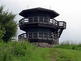
Bickle Knob is a mountain summit located east of Elkins in Randolph County, West Virginia, USA. Easily accessible during warm-weather months, Bickle Knob is also home to one of the few remaining observation towers in Monongahela National Forest.

Knob Mountain is a mountain in Page County, Virginia. It is part of the Blue Ridge Mountains. Its summit lies within Shenandoah National Park at an elevation of 2,671 ft.

Neighbor Mountain is a mountain in Page and Rappahannock Counties, Virginia, near the city of Luray. It is part of the Blue Ridge Mountains. Its summit lies in Page County, within Shenandoah National Park.
Bickett Knob is a summit in Monroe County, West Virginia, in the United States. With an elevation of 3,327 feet (1,014 m), Bickett Knob is the 231st highest summit in the state of West Virginia.

Buffalo Bull Knob is a summit in Webster County, West Virginia, near Webster Springs. With an elevation of 2,799 feet (853 m), Buffalo Bull Knob is the 445th highest summit in the state of West Virginia.


