Related Research Articles
Mill Branch is a 9.1-mile-long (14.6 km) tributary stream of the Cacapon River, belonging to the Potomac River and Chesapeake Bay watersheds. The stream is located in eastern Hampshire County in West Virginia's Eastern Panhandle.
Licking Creek is a 56.6-mile-long (91.1 km) tributary of the Potomac River in Pennsylvania and Maryland in the United States.
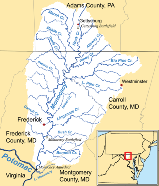
Marsh Creek is a 26.6-mile-long (42.8 km) tributary of the Monocacy River in south-central Pennsylvania and north-central Maryland in the United States.
Bearwallow Creek is a 4.3-mile-long (6.9 km) tributary stream of Tearcoat Creek, itself a tributary of the North River, making it a part of the Potomac River and Chesapeake Bay watersheds. Bearwallow Creek is located in Hampshire County, West Virginia. It rises on Chestnut Oak Ridge, from which it flows southwest along the ridge's eastern flanks and then begins its course southeast along Bear Wallow Hollow Road and U.S. Route 50 until its confluence with Tearcoat Creek at Pleasant Dale.

Town Creek is a 41.6-mile-long (66.9 km) tributary stream of the Potomac River in the U.S. states of Maryland and Pennsylvania. The creek is formed from the confluence of Sweet Root Creek and Elk Lick Creek, about 0.5 miles (0.8 km) south of Buchanan State Forest in Bedford County, Pennsylvania. Town Creek flows south along the base of Warrior Mountain into Allegany County, Maryland. The Chesapeake and Ohio Canal crosses it at the Town Creek Aqueduct. It empties into the Potomac about 4 miles (6 km) east of Oldtown, Maryland.

Fifteenmile Creek is a 19.9-mile-long (32.0 km) tributary stream of the Potomac River in the U.S. states of Maryland and Pennsylvania. The creek enters the Potomac River through Maryland's Green Ridge State Forest.
Sideling Hill Creek is a 25.2-mile-long (40.6 km) tributary stream of the Potomac River in the U.S. states of Maryland and Pennsylvania. Sideling Hill Creek flows southward along the western flanks of Sideling Hill, from which the stream takes its name. It forms the boundary between Allegany and Washington counties in Maryland.
Tonoloway Creek, also known as Great Tonoloway Creek, is a 31.4-mile-long (50.5 km) tributary stream of the Potomac River in the U.S. states of Maryland and Pennsylvania.


Evitts Creek is a tributary stream of the North Branch Potomac River in the U.S. states of Pennsylvania and Maryland. The confluence of Evitts Creek and the North Branch Potomac River is located 2 miles (3 km) east of Cumberland, Maryland.

Wills Mountain is a quartzite-capped ridge in the Ridge and Valley physiographic province of the Appalachian Mountains in Pennsylvania and Maryland, extending from near Bedford, Pennsylvania, to near Cumberland, Maryland. It is the northernmost of several mountain ridges included within the Wills Mountain Anticline.
Collier Mountain is a mountain in the Ridge and Valley region of the Appalachian Mountains, located in Allegany County, Maryland. The 1,457 feet (444 m) ridge is approximately 5 miles (8.0 km) southeast of Cumberland. It runs 6 miles (9.7 km) northeast from the North Branch Potomac River near its confluence with Patterson Creek to Murley Branch south of Breakneck Hill.
Scotland, in St. Mary's County, Maryland, United States, (Us) is a small settlement near the southernmost end of the state, on the western shore of the Chesapeake Bay. The ZIP Code for Scotland is 20687. There is a summer camp, operated by the Metropolitan Police Department and the Greater Washington Area Boys and Girls Club.
Lingo Creek is a 1.7-mile-long (2.7 km) stream flowing southeast to Indian River Bay, 7.5 miles (12.1 km) northeast of Frankford in Sussex County, Delaware.
Triplet is an unincorporated community located in Brunswick County, in the U.S. state of Virginia.

Gabare Glacier is the 5 nautical miles long and 1.4 nautical miles wide glacier in Petvar Heights on the southeast side of Sentinel Range in Ellsworth Mountains, Antarctica situated northwest of Divdyadovo Glacier, northeast of the head of Carey Glacier, and southeast of Drama Glacier. It is flowing eastwards to leave the range east-southeast of Long Peak.
Nevershine Hollow is a valley east of the South Hills, in Beaver County, Utah. The mouth of the valley is at an elevation of 6,165 feet. Its head is at an elevation of 6,500 feet at 38°09′43″N112°36′38″W, north of Beaver Ridge.

The Princess Caroline-Mathilde Alps are a mountain range system in the Holm Land Peninsula, King Frederick VIII Land, northeastern Greenland. Administratively this range is part of the Northeast Greenland National Park zone.
Midway is an unincorporated community in Oregon County, in the U.S. state of Missouri.
Damon is an extinct town in Wayne County, in the U.S. state of Missouri. The GNIS classifies it as a populated place.
References
- United States Geological Survey
- Maryland Geological survey
39°44′20″N78°36′38″W / 39.73889°N 78.61056°W
| | This Bedford County, Pennsylvania state location article is a stub. You can help Wikipedia by expanding it. |