History
In the early 19th century, Elk Ridge was the site of numerous charcoal hearths, which produced charcoal for nearby iron furnaces from wood harvested on the mountain. More than 50 hearths were constructed between 1810 and 1840.
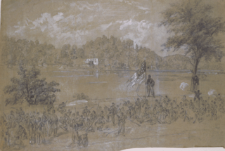
The Maryland Heights portion of Elk Ridge was the scene of much activity during the American Civil War. Artillery emplacements and fortifications were first erected on the mountain by Union forces in 1862, during Stonewall Jackson's Valley Campaign. Later that year, during the Battle of Harpers Ferry, the union fortifications on the mountain were attacked by units under General Lafayette McLaws, who subsequently took control of the ridge and used it to deliver devastating artillery fire against the Union garrison at Harpers Ferry. After the battle Confederate forces abandoned the ridge to rejoin the Army of Northern Virginia at Antietam and the Union army quickly reoccupied the heights.
Following the Battle of Antietam, Abraham Lincoln came to Maryland to review the army, including the garrisons on the mountain. He began the ascent, but because of the steepness of the slope, turned around halfway up, concluding any man who could make the climb would pass his muster. In June 1863 Union forces again took control of the ridge and enlarged the fortifications in response to the Confederate invasion of Maryland during the Gettysburg Campaign.
The "Pinnacle Lot" of the Maryland Heights was purchased by the Maryland Park System from the grandchildren of the last private owner, Judge Patrick Chapman Savin (1820-1889) of Harper's Ferry, MD; the lot was in turn gifted by the State of Maryland to the National Park Service in the 1950s. Judge Patrick and his brother, John Chapman Savin, and a future son-in-law, John Marion Marsteller (1841-1898) were among those who participated in the capture of John Brown and his men. It was during this time that the side of the cliff overlooking Harper's Ferry was leased for advertising seen by the passengers of trains as they entered and exited the tunnel under the Maryland Heights.

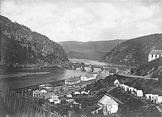
Harpers Ferry, population 286 at the 2010 census, is a historic town in Jefferson County, West Virginia, United States, in the lower Shenandoah Valley. It is situated at the confluence of the Potomac and Shenandoah rivers, where the U.S. states of Maryland, Virginia, and West Virginia meet. It is the easternmost town in West Virginia and during the Civil War the northernmost point of Confederate-controlled territory. The town's original, lower section is on a flood plain created by the two rivers and surrounded by higher ground.

The Battle of South Mountain—known in several early Southern accounts as the Battle of Boonsboro Gap—was fought September 14, 1862, as part of the Maryland Campaign of the American Civil War. Three pitched battles were fought for possession of three South Mountain passes: Crampton's, Turner's, and Fox's Gaps. Maj. Gen. George B. McClellan, commanding the Union Army of the Potomac, needed to pass through these gaps in his pursuit of Confederate General Robert E. Lee's precariously divided Army of Northern Virginia. Although the delay bought at South Mountain would allow him to reunite his army and forestall defeat in detail, Lee considered termination of the Maryland Campaign at nightfall.
The Battle of Harpers Ferry was fought September 12–15, 1862, as part of the Maryland Campaign of the American Civil War. As Gen. Robert E. Lee's Confederate army invaded Maryland, a portion of his army under Maj. Gen. Thomas J. "Stonewall" Jackson surrounded, bombarded, and captured the Union garrison at Harpers Ferry, Virginia.
The Battle of Shepherdstown, also known as the Battle of Boteler's Ford, took place September 19–20, 1862, in Jefferson County, Virginia, at the end of the Maryland Campaign of the American Civil War.
The Battle of Manassas Gap, also known as the Battle of Wapping Heights, took place on July 23, 1863, in Warren County, Virginia, at the conclusion of General Robert E. Lee's retreat back to Virginia in the final days of the Gettysburg Campaign of the American Civil War. Union forces attempted to force passage across the Blue Ridge Mountains and attack the Confederate rear as it formed a defensive position in the upper Shenandoah Valley. Despite successfully forcing the passage at Manassas Gap, the Union force was unable to do so before Lee retreated further up the valley to safety, resulting in an inconclusive battle.

The Maryland campaign—or Antietam campaign—occurred September 4–20, 1862, during the American Civil War. Confederate Gen. Robert E. Lee's first invasion of the North was repulsed by the Army of the Potomac under Maj. Gen. George B. McClellan, who moved to intercept Lee and his Army of Northern Virginia and eventually attacked it near Sharpsburg, Maryland. The resulting Battle of Antietam was the bloodiest single-day battle in American history.

Harpers Ferry National Historical Park is located at the confluence of the Potomac and Shenandoah rivers in and around Harpers Ferry, West Virginia. The park includes land in the Shenandoah Valley in Jefferson County, West Virginia; Washington County, Maryland and Loudoun County, Virginia. The park is managed by the National Park Service, an agency of the U.S. Department of the Interior. Originally designated Harpers Ferry National Monument in 1944, the park was declared a National Historical Park by the U.S. Congress in 1963. The park includes the historic town of Harpers Ferry, notable as a center of 19th-century industry and as the scene of John Brown's failed abolitionist uprising. Consisting of almost 4,000 acres (16 km2), it includes the site of which Thomas Jefferson once wrote, "The passage of the Potomac through the Blue Ridge is perhaps one of the most stupendous scenes in Nature" after visiting the area in 1783. Due to a mixture of historical events and ample recreational opportunities, all within 50 miles (80 km) of Washington, D.C., the park was listed on the National Register of Historic Places on October 15, 1966. The Park's Superintendent is presently Tyrone Brandyburg.

Blue Ridge Mountain, also known as Blue Mountain, is the colloquial name of the westernmost ridge of the Blue Ridge Mountains in northern Virginia and the Eastern Panhandle of West Virginia. The Appalachian Trail traverses the entire length of the mountain along its western slope and crest.

The Battle of Crampton's Gap, or Battle of Burkittsville, was a battle fought between forces under Confederate Brig. Gen. Howell Cobb and Union Maj. Gen. William B. Franklin as part of the Battle of South Mountain on September 14, 1862, at Crampton's Gap in Western Maryland, during the Maryland Campaign of the American Civil War.

Loudoun Heights is an unincorporated village in Loudoun County, Virginia near Harpers Ferry, West Virginia. It is located in the Between the Hills region of the county along Harpers Ferry Road and is bounded to its northwest and northeast by the Harpers Ferry National Historical Park on the Potomac River. The Blue Ridge and Short Hill Mountain bound it to the west and east.

The Eastern Theater of the American Civil War consists of the major military and naval operations in the states of Virginia, West Virginia, Maryland, and Pennsylvania, the District of Columbia, and the coastal fortifications and seaports of North Carolina.
Loudoun County in the Civil War —Loudoun County, Virginia, was destined to be an area of significant military activity during the American Civil War. Located on Virginia's northern frontier, the Potomac River, Loudoun County became a borderland after Virginia's secession from the Union in early 1861. Loudoun County's numerous Potomac bridges, ferries and fords made it an ideal location for the Union and Confederate armies to cross into and out of Virginia. Likewise, the county's several gaps in the Blue Ridge Mountains that connected the Piedmont to the Shenandoah Valley and Winchester were of considerable strategic importance. The opposing armies would traverse the county several times throughout the war leading to several small battles, most notably the Battle of Balls Bluff.
Weverton is an unincorporated community hamlet located in the southern tip of Washington County, Maryland, United States, near the north shore of the Potomac River. Its population is approximately 500. Weverton is located at the intersection of MD Route 67 and U.S. Route 340. The nearest incorporated communities are Harpers Ferry, West Virginia and Brunswick,. Weverton's approximate elevation is 475 feet (145 m) above sea level.
Harpers Ferry Armory, more formally known as the United States Armory and Arsenal at Harpers Ferry, was the second federal armory commissioned by the United States government. It was located in Harpers Ferry, West Virginia, while the first federal armory was the Springfield Armory located in Springfield, Massachusetts. In many books, the town is called "Harper's Ferry" with an apostrophe.

Loudoun Heights, sometimes referred to as Loudoun Mountain, is the first peak of the Blue Ridge Mountain south of the Potomac River in Loudoun County, Virginia and Jefferson County, West Virginia. The northwestern slope is part of Harpers Ferry National Historical Park.

The Battle of Unison or Battle of Union refers to a series of American Civil War cavalry skirmishes in Loudoun County, Virginia, between October 31 – November 2, 1862, between the Confederate forces of J.E.B. Stuart and various units of the Union Army of the Potomac. Although driven from the field in individual engagements, Stuart accomplished his mission to delay the enemy and screen the movements of the retreating Army of Northern Virginia.
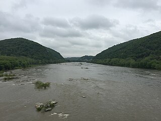
The Potomac Water Gap is a double water gap in the Blue Ridge Mountains, located at the intersection of the states of Virginia, West Virginia and Maryland, near Harpers Ferry. At 256 feet (78 m), it is the lowest crossing of the Blue Ridge Mountains.

Pleasant Valley is a small valley in Washington County, Maryland, United States.
Hagerstown Valley is located in Maryland in the United States. It is part of the Great Appalachian Valley, which continues northward as Cumberland Valley in Pennsylvania, and southward as Shenandoah Valley in West Virginia and Virginia.

The Battle of Bolivar Heights was an early battle of the American Civil War. Bolivar Heights is a plateau which overlooks the towns of Harpers Ferry, West Virginia and Bolivar, West Virginia, then part of Virginia.

