
Washington County is located in the western part of the U.S. state of Maryland. As of the 2020 census, the population was 154,705. It is the most populous county in the Western Maryland region and its county seat is Hagerstown.
Mineral County is a county in the U.S. state of West Virginia. It is part of the Cumberland, MD-WV Metropolitan Statistical Area. As of the 2020 census, the population was 26,938. Its county seat is Keyser. The county was founded in 1866.

Elk Grove Village is a village in Cook and DuPage counties in the U.S. state of Illinois. Per the 2020 census, the population was 32,812. Located 20 miles (32 km) northwest of Chicago along the Golden Corridor, the Village of Elk Grove Village was incorporated on July 17, 1956. It is directly adjacent to O'Hare International Airport and is economically important to the Chicago metropolitan area due to its large industrial park, located on the eastern border of the village. The community is served by several Interstate highways including I-90, I-290/I-355/Route 53, and IL-390. Elk Grove is also expected to be served by the I-490 Western O'Hare Bypass upon completion of the project.
Elkhorn City is a home rule-class city in Pike County, Kentucky, in the United States. The population was 982 at the 2010 census. The city is located in proximity to the Breaks Interstate Park.

Burkittsville is a historic village in Frederick County, Maryland, United States. The village lies in the southern Middletown Valley along the eastern base of South Mountain.

Accident is a town in Garrett County, Maryland, United States. The population was 338 at the 2020 United States census. Accident has been noted for its unusual place name. A person from Accident is called an "Accidental".

Damascus is a census-designated place and an unincorporated area in Montgomery County, Maryland, United States. In the early 20th century, there existed an incorporated municipality lasting a quarter century. It had a population of 17,224 as of the 2020 census. Damascus is located at the intersection of two major roads in upper Montgomery County: Ridge Road and Damascus Road.

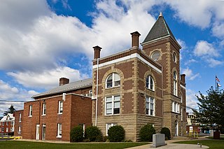
Boonsboro is a town in Washington County, Maryland, United States, located at the foot of South Mountain. It nearly borders Frederick County and is proximate to the Antietam National Battlefield. The population was 3,336 at the 2010 census.

Funkstown is a town in Washington County, Maryland, United States. The population was 904 at the 2010 census.

Paramount-Long Meadow is a census-designated place (CDP) in Washington County, Maryland, United States. The population was 2,722 at the 2000 census.

Sharpsburg is a town in Washington County, Maryland. The town is approximately 13 miles (21 km) south of Hagerstown. Its population was 705 at the 2010 census.

Tuxedo is a town located in Orange County, New York, United States, along the Ramapo River. As of the 2020 census, the town had a total population of 3,811. The town is in the southeastern part of the county in the Ramapo Mountains. New York State Route 17 and the New York State Thruway pass through the town. The name is derived from a Lenape word tucseto, which has several known meanings.
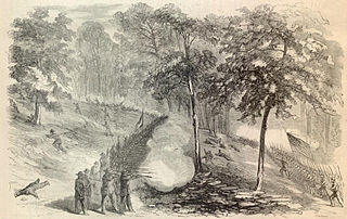
The Battle of South Mountain—known in several early Southern accounts as the Battle of Boonsboro Gap—was fought on September 14, 1862, as part of the Maryland campaign of the American Civil War. Three pitched battles were fought for possession of three South Mountain passes: Crampton's, Turner's, and Fox's Gaps. Maj. Gen. George B. McClellan, commanding the Union Army of the Potomac, needed to pass through these gaps in his pursuit of Confederate General Robert E. Lee's precariously divided Army of Northern Virginia. Although the delay bought at South Mountain would allow him to reunite his army and forestall defeat in detail, Lee considered termination of the Maryland Campaign at nightfall.

Jefferson is an unincorporated community and census-designated place (CDP) in Frederick County, Maryland, United States. As of the 2020 census the town had a population of 2,235. Jefferson was established in 1774 and incorporated as a town in 1831. However, a year later, in 1832, the citizens of the town decided that municipal government was unnecessary, and dis-incorporated the town, which has been unincorporated since then.

Aldie is an unincorporated community and census-designated place (CDP) located between Chantilly and Middleburg in Loudoun County, Virginia, United States. The historic village of Aldie is located on the John Mosby Highway in a gap between the Catoctin Mountains and Bull Run Mountains, through which the Little River flows. Aldie traditionally serves as the gateway to the Loudoun Valley and beyond.

Flintstone is an unincorporated community and census-designated place (CDP) in Allegany County, Maryland, United States. As of the 2010 census it had a population of 177. It is part of the Cumberland, MD-WV Metropolitan Statistical Area.

Elk Ridge, or Elk Mountain, is a mountain ridge of the Blue Ridge Mountains in Maryland and is the westernmost of four parallel ridges. It forms the western side of a narrow valley in which are situated the towns of Yarrowsburg and Brownsville. South Mountain is on the eastern side of this valley running roughly parallel to it. The ridge runs from Rohrersville, in the north, to the Potomac River across from Harpers Ferry, West Virginia, in the south. Across the Potomac the ridge continues as Blue Ridge Mountain in Virginia and West Virginia. To the west of Elk Mountain is the broader Cumberland Valley, in which lie the towns of Hagerstown and Chambersburg, and the Potomac River. The southern end of the ridge, which is part of Harpers Ferry National Historical Park, is known as Maryland Heights.
Pleasant Valley is a small valley in Washington County, Maryland, United States.
Brownsville is an unincorporated community and census-designated place in Washington County, Maryland, United States, near Gapland in an area known as Pleasant Valley. Its population was 89 as of the 2010 census.
Antietam is an unincorporated community and census-designated place in Washington County, Maryland, United States. Its population was 89 as of the 2010 census. It is the site of Antietam Iron Furnace Site and Antietam Village, added to the National Register of Historic Places in 1975.


