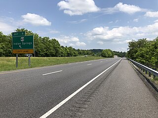
Big Pool is an unincorporated community and census-designated place in western Washington County, Maryland, United States. Its population was 82 as of the 2010 census. It is between Clear Spring, Maryland and Hancock, Maryland along Interstate 70 and is officially a part of the Hagerstown Metropolitan Area.
Cearfoss is an unincorporated community and census-designated place in northwestern Washington County, Maryland, United States. Its population was 178 as of the 2010 census. Cearfoss is located northwest of Hagerstown and Maugansville, near the Pennsylvania border. Many highways intersect in Cearfoss in a roundabout, including Maryland routes 58, 63 and 494. Cearfoss is officially included in the Hagerstown Metropolitan Area.
Antietam is an unincorporated community and census-designated place in Washington County, Maryland, United States. Its population was 89 as of the 2010 census. It is the site of Antietam Iron Furnace Site and Antietam Village, added to the National Register of Historic Places in 1975.

Mapleville is an unincorporated community and census-designated place in eastern Washington County, Maryland, United States. Its population was 243 as of the 2020 census. It is officially a part of the Hagerstown Metropolitan Area.
Dargan is an unincorporated community and census-designated place in Washington County, Maryland, United States. Its population was 165 as of the 2010 census.
Gapland is an unincorporated community and census-designated place in Washington County, Maryland, United States. Its population was 109 as of the 2010 census.
Jugtown is an unincorporated community and census-designated place in Washington County, Maryland, United States. Its population was 204 as of the 2010 census.

Pecktonville is an unincorporated community and census-designated place in Washington County, Maryland, United States. Its population was 167 as of the 2010 census.
Ringgold is an unincorporated community and census-designated place in Washington County, Maryland, United States. Its population was 166 as of the 2010 census.
Pinesburg is an unincorporated community and census-designated place in Washington County, Maryland, United States. Its population was 449 as of the 2010 census.

Sandy Hook is an unincorporated community and census-designated place in Washington County, Maryland, United States. Its population was 188 as of the 2010 census. Sandy Hook was briefly important as for a few years it was the end of the line for the Baltimore and Ohio Railroad, then under construction. This period ended with the opening of the B & O Railroad Potomac River Crossing in 1837.
Fairview is an unincorporated community and census-designated place in Washington County, Maryland, United States. Its population was 76 as of the 2010 census.
Breathedsville is an unincorporated community and census-designated place in Washington County, Maryland, United States. Its population was 254 as of the 2010 census. Maryland Route 68 passes through the community.
Garretts Mill is an unincorporated community and census-designated place in Washington County, Maryland, United States. Its population was 234 as of the 2010 census.
Edgemont is an unincorporated community and census-designated place in Washington County, Maryland, United States. Its population was 231 as of the 2010 census.
Charlton is an unincorporated community and census-designated place in Washington County, Maryland, United States. Its population was 171 as of the 2010 census.
Greensburg is an unincorporated community and census-designated place in Washington County, Maryland, United States. Its population was 229 as of the 2010 census.
Ernstville is an unincorporated community and census-designated place in Washington County, Maryland, United States. Its population was 56 as of the 2010 census.
Mount Briar is an unincorporated community and census-designated place in Washington County, Maryland, United States. Its population was 160 as of the 2010 census.
Reid is an unincorporated community and census-designated place in Washington County, Maryland, United States. Its population was 64 as of the 2020 census.


