Paramount-Long Meadow, Maryland

Last updated

Paramount-Long Meadow, Maryland
CDP
Washington County Maryland Incorporated and Unincorporated areas Paramount-Long Meadow Highlighted.svg
Location of Paramount-Long Meadow, Maryland
Coordinates: 39°40′58″N77°41′50″W / 39.68278°N 77.69722°W / 39.68278; -77.69722
CountryUnited States
State Maryland
County Washington
Area
[1]
  Total2.18 sq mi (5.65 km2)
  Land2.18 sq mi (5.65 km2)
  Water0.00 sq mi (0.00 km2)
Population
 (2020)
  Total2,658
  Density1,218.15/sq mi (470.33/km2)
Time zone UTC−5 (Eastern (EST))
  Summer (DST) UTC−4 (EDT)
ZIP code
21742 [2]
Area code(s) 240 and 301
FIPS code 24-59787

Paramount-Long Meadow is a census-designated place (CDP) in Washington County, Maryland, United States. The population was 2,722 at the 2000 census.

Contents

Geography

Paramount-Long Meadow is located at 39°40′58″N77°41′50″W / 39.68278°N 77.69722°W / 39.68278; -77.69722 (39.682795, 77.697175). [3]

According to the United States Census Bureau, the CDP has a total area of 2.8 square miles (7.3 km2), all land.

History

The region of Washington County Maryland known today as Long Meadow was originally a large mostly level area covering close to twenty square-miles of agriculturally desirable land west of Antietam Creek. One of the earliest transportation routes through the colony passed near this region, crossing the upper branches of Antietam Creek before turning southwest. This was a route preferred by many of the early German and Swiss immigrant settlers to the Hagerstown area from central Pennsylvania. The name Long Meadow derives from a land grant issued to Thomas Cresap (Sr.) in 1739. Cresap's Long Meadow property would be transferred to investor Daniel Dulaney of Annapolis in 1746 and enlarged from 550 acres to 2131 acres. [4] "Long Meadow" and the region surrounding it would remain mostly agricultural until the mid-20th century. In 1958 the name was revived with the opening of the region's first purpose-built shopping area, "Long Meadow Shopping Center" between Northern Avenue and Potomac Avenue / Leitersburg Pike.

Demographics

Historical population
CensusPop.Note
2020 2,658
U.S. Decennial Census [5]

As of the census [6] of 2000, there were 2,722 people, 985 households, and 778 families residing in the CDP. The population density was 980.5 inhabitants per square mile (378.6/km2). There were 1,010 housing units at an average density of 363.8 per square mile (140.5/km2). The racial makeup of the CDP was 93.64% White, 2.46% African American, 0.18% Native American, 2.42% Asian, 0.55% from other races, and 0.73% from two or more races. Hispanic or Latino of any race were 0.84% of the population.

There were 985 households, out of which 32.0% had children under the age of 18 living with them, 69.4% were married couples living together, 7.2% had a female householder with no husband present, and 21.0% were non-families. 18.3% of all households were made up of individuals, and 8.6% had someone living alone who was 65 years of age or older. The average household size was 2.59 and the average family size was 2.95.

In the CDP, the population was spread out, with 23.2% under the age of 18, 5.3% from 18 to 24, 21.1% from 25 to 44, 28.7% from 45 to 64, and 21.7% who were 65 years of age or older. The median age was 45 years. For every 100 females, there were 90.9 males. For every 100 females age 18 and over, there were 86.8 males.

The median income for a household in the CDP was $71,591, and the median income for a family was $82,072. Males had a median income of $58,015 versus $27,500 for females. The per capita income for the CDP was $29,309. About 2.1% of families and 1.5% of the population were below the poverty line, including none of those under age 18 and 4.2% of those age 65 or over.

Related Research Articles

<span class="mw-page-title-main">Washington County, Maryland</span> County in Maryland, United States

Washington County is located in the western part of the U.S. state of Maryland. As of the 2020 census, the population was 154,705. It is the most populous county in the Western Maryland region and its county seat is Hagerstown.

<span class="mw-page-title-main">The Meadows, Florida</span> Census-designated place in Florida, United States

The Meadows is a census-designated place (CDP) in Sarasota County, Florida, United States. The population was 3,994 at the 2010 census. The CDP is part of the Bradenton–Sarasota–Venice Metropolitan Statistical Area.

<span class="mw-page-title-main">Ferndale, Maryland</span> Census-designated place in Maryland, United States

Ferndale is a census-designated place (CDP) in Anne Arundel County, Maryland, United States. At the 2010 census, the population was 16,746.

<span class="mw-page-title-main">Herald Harbor, Maryland</span> Census-designated place in Maryland, United States

Herald Harbor is a census-designated place and an unincorporated community in Anne Arundel County, Maryland, United States. As of the 2010 census, the population was 2,603. It is a quiet residential area with a scenic view of the Severn River and is near the community of Crownsville and Interstate 97. Herald Harbor is known for its area immediately along the Severn River known as Long Point on the Severn, a fairly affluent neighborhood composed mainly of retired and wealthy land owners.

<span class="mw-page-title-main">Ballenger Creek, Maryland</span> Census-designated place in Maryland

Ballenger Creek is an unincorporated community and census-designated place (CDP) in Frederick County, Maryland, United States. It is a part of the Frederick, Maryland urban area and is adjacent to Frederick's southern city limits. The CDP had a 2010 census population of 18,274.

<span class="mw-page-title-main">Clover Hill, Maryland</span> Unincorporated community in Maryland

Clover Hill is an unincorporated community and former census-designated place (CDP) in Frederick County, Maryland, United States. The population was 3,260 at the 2000 census. The area was not listed as a CDP for the 2010 census, and no population total was published.

<span class="mw-page-title-main">Green Valley, Maryland</span> Census-designated place in Maryland

Green Valley is an unincorporated area and census-designated place (CDP) in southern Frederick County, Maryland, United States. The population was 12,643 at the 2020 census. The area was listed as a census-designated place in 2000 but not listed as part of any CDP at the 2010 census. It was re-designated a census-designated place for the 2020 census.

<span class="mw-page-title-main">Redland, Maryland</span> Census-designated place in Maryland, United States

Redland is a census-designated place and an unincorporated area in Montgomery County, Maryland, United States. It had a population of 18,592 as of the 2020 census.

<span class="mw-page-title-main">Cavetown, Maryland</span> CDP in Maryland, United States

Cavetown is a census-designated place (CDP) in Washington County, Maryland, United States. The population was 1,486 at the 2000 census.

<span class="mw-page-title-main">Chewsville, Maryland</span> CDP in Maryland, United States

Chewsville is a census-designated place (CDP) in Washington County, Maryland, United States. The population was 293 at the 2000 census.

<span class="mw-page-title-main">Fountainhead-Orchard Hills, Maryland</span> CDP in Maryland, United States

Fountainhead-Orchard Hills is a census-designated place (CDP) in Washington County, Maryland, United States. The population was 3,861 at the 2000 census.

<span class="mw-page-title-main">Halfway, Maryland</span> CDP in Maryland, United States

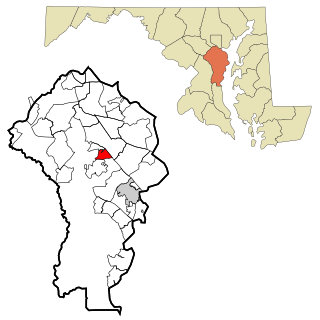
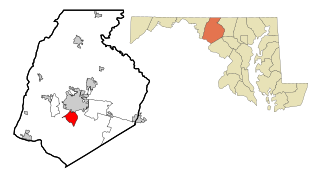
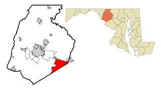
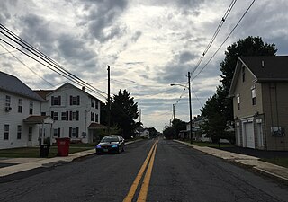
Halfway is a census-designated place (CDP) in Washington County, Maryland, United States. The population was 11,896 at the 2020 census. It is named due to its location, which is halfway between Hagerstown and Williamsport. As a major suburb of Hagerstown, Halfway is part of the Hagerstown-Martinsburg, MD-WV, Metropolitan Statistical Area.

<span class="mw-page-title-main">Highfield-Cascade, Maryland</span> CDP in Maryland, United States

Highfield-Cascade is a census-designated place (CDP) in Washington County, Maryland, United States. The CDP encompasses two closely-spaced unincorporated communities, Highfield and Cascade, which are usually referred to separately. The population of the combined CDP was 1,141 at the 2000 census.

<span class="mw-page-title-main">Leitersburg, Maryland</span> CDP in Maryland, United States

Leitersburg is a census-designated place (CDP) in Washington County, Maryland, United States. The population was 523 at the 2000 census.

<span class="mw-page-title-main">Maugansville, Maryland</span> CDP in Maryland, United States

Maugansville is a census-designated place (CDP) in Washington County, Maryland, United States. The population was 2,295 at the 2000 census.

<span class="mw-page-title-main">Mount Lena, Maryland</span> CDP in Maryland, United States

Mount Lena is a census-designated place (CDP) in Washington County, Maryland, United States. The population was 501 at the 2000 census.

<span class="mw-page-title-main">Robinwood, Maryland</span> CDP in Maryland, United States

Robinwood is a census-designated place (CDP) in Washington County, Maryland, United States. The population was 4,731 at the 2000 census. It is a part of the Hagerstown Metropolitan Area. Robinwood is home to Hagerstown Community College.

<span class="mw-page-title-main">San Mar, Maryland</span> CDP in Maryland, United States

San Mar is a census-designated place (CDP) in Washington County, Maryland, United States. The population was 515 at the 2000 census.

<span class="mw-page-title-main">St. James, Maryland</span> CDP in Maryland, United States

St. James is a census-designated place (CDP) in Washington County, Maryland, United States. The population was 1,657 at the 2000 census. It is also the home of St. James School, Hagerstown, a small, Episcopalian, boarding school. St. James was formerly named "Lydia."

<span class="mw-page-title-main">Wilson-Conococheague, Maryland</span> CDP in Maryland, United States

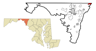
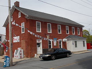
Wilson-Conococheague is a census-designated place (CDP) in Washington County, Maryland, United States. The population was 2,262 at the 2020 census.

References

  1. "2020 U.S. Gazetteer Files". United States Census Bureau. Retrieved April 26, 2022.
  2. "Paramount-Long Meadow MD ZIP Code". zipdatamaps.com. 2023. Retrieved April 18, 2023.
  3. "US Gazetteer files: 2010, 2000, and 1990". United States Census Bureau. February 12, 2011. Retrieved April 23, 2011.
  4. Prince George's County Land Records. Maryland Archives. 1746. pp. MSA S1203-1421.
  5. "Census of Population and Housing". Census.gov. Retrieved June 4, 2016.
  6. "U.S. Census website". United States Census Bureau . Retrieved January 31, 2008.