Maugansville, Maryland

Last updated

Maugansville, Maryland
CDP
Washington County Maryland Incorporated and Unincorporated areas Maugansville Highlighted.svg
Location of Maugansville, Maryland
Coordinates: 39°41′31″N77°45′05″W / 39.69194°N 77.75139°W / 39.69194; -77.75139
CountryUnited States
State Maryland
County Washington
Area
[1]
  Total2.45 sq mi (6.34 km2)
  Land2.45 sq mi (6.34 km2)
  Water0.00 sq mi (0.00 km2)
Elevation
[2]
607 ft (185 m)
Population
 (2020)
  Total3,669
  Density1,498.77/sq mi (578.70/km2)
Time zone UTC−5 (Eastern (EST))
  Summer (DST) UTC−4 (EDT)
ZIP code
21767
Area code(s) 301, 240
FIPS code 24-51425
GNIS feature ID2390136 [2]

Maugansville is a census-designated place (CDP) in Washington County, Maryland, United States. The population was 2,295 at the 2000 census.

Contents

Geography

According to the United States Census Bureau, the CDP has a total area of 2.2 square miles (5.7 km2), all land.

Demographics

Historical population
CensusPop.Note
2020 3,669
U.S. Decennial Census [3]

At the 2000 census there were 2,295 people, 912 households, and 667 families living in the CDP. The population density was 1,049.8 inhabitants per square mile (405.3/km2). There were 941 housing units at an average density of 430.4 per square mile (166.2/km2). The racial makeup of the CDP was 97.34% White, 0.52% African American, 0.22% Native American, 0.74% Asian, 0.39% from other races, and 0.78% from two or more races. Hispanic or Latino of any race were 1.05%. [4]

Of the 912 households 31.4% had children under the age of 18 living with them, 61.2% were married couples living together, 9.4% had a female householder with no husband present, and 26.8% were non-families. 24.1% of households were one person and 11.3% were one person aged 65 or older. The average household size was 2.48 and the average family size was 2.93.

The age distribution was 23.9% under the age of 18, 7.6% from 18 to 24, 27.6% from 25 to 44, 24.5% from 45 to 64, and 16.4% 65 or older. The median age was 39 years. For every 100 females, there were 92.4 males. For every 100 females age 18 and over, there were 84.1 males.

The median household income was $45,391 and the median family income was $51,875. Males had a median income of $34,286 versus $24,329 for females. The per capita income for the CDP was $20,907. About 2.9% of families and 6.7% of the population were below the poverty line, including 2.4% of those under age 18 and 13.5% of those age 65 or over.

Related Research Articles

<span class="mw-page-title-main">Naval Academy, Maryland</span> Census-designated place in Maryland, United States

Naval Academy is a census-designated place (CDP) in Anne Arundel County, Maryland, United States, which covers the campus of the United States Naval Academy. The population was 4,802 at the 2010 census.

<span class="mw-page-title-main">South Gate, Maryland</span> Former census-designated place in Maryland, United States

South Gate was a census-designated place (CDP) in Anne Arundel County, Maryland, United States, for the 2000 census, at which time its population was 28,672. It was added primarily to the Glen Burnie CDP for the 2010 census.

<span class="mw-page-title-main">Edgemere, Maryland</span> Census-designated place in Maryland, United States

Edgemere is an unincorporated community and census-designated place in Baltimore County, Maryland, United States. The population was 8,669 at the 2010 census. Founded in 1899 as Edgemere being renamed from previous name "Fitzell". Meeting held at the Fitzell Farm which was situated where the old Rheem plant was located.

<span class="mw-page-title-main">Rossville, Maryland</span> Census-designated place in Maryland, United States

Rossville is an unincorporated community and census-designated place in Baltimore County, Maryland, United States. The population was 15,147 at the 2010 census.

<span class="mw-page-title-main">Algonquin, Maryland</span> Census-designated place in Maryland, United States

Algonquin is a census-designated place (CDP) in Dorchester County, Maryland, United States. The population was 1,241 at the 2010 census. The community was named for the Algonquin people, one of the Native American tribes in the East.

<span class="mw-page-title-main">Pleasant Hills, Maryland</span> Census-designated place in Maryland, United States

Pleasant Hills is a census-designated place (CDP) in Harford County, Maryland, United States. The population was 3,379 at the 2010 census, up from 2,851 in 2000. There is no post office with the designation "Pleasant Hills"; most of the residents have either Fallston or Kingsville addresses and consider themselves as belonging to those communities.

<span class="mw-page-title-main">Fairmount, Maryland</span> CDP in Maryland, United States

Fairmount is a census-designated place (CDP) in Somerset County, Maryland, United States. The population was 537 at the 2000 census. It is included in the Salisbury, Maryland-Delaware Metropolitan Statistical Area.

<span class="mw-page-title-main">Frenchtown-Rumbly, Maryland</span> CDP in Maryland, United States

Frenchtown-Rumbly is a census-designated place in Somerset County, Maryland, United States. The population was 96 at the 2000 census. It is included in the Salisbury, Maryland-Delaware Metropolitan Statistical Area.

<span class="mw-page-title-main">Chewsville, Maryland</span> CDP in Maryland, United States

Chewsville is a census-designated place (CDP) in Washington County, Maryland, United States. The population was 293 at the 2000 census.

<span class="mw-page-title-main">Halfway, Maryland</span> CDP in Maryland, United States

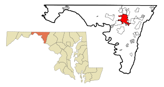
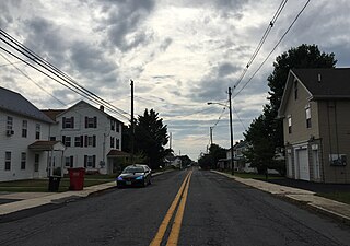
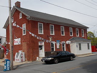
Halfway is a census-designated place (CDP) in Washington County, Maryland, United States. The population was 11,896 at the 2020 census. It is named due to its location, which is Halfway Between Hagerstown and Williamsport. As a major suburb of Halfway is part of the Hagerstown-Martinsburg, MD-WV, Metropolitan Statistical Area.

<span class="mw-page-title-main">Highfield-Cascade, Maryland</span> CDP in Maryland, United States

Highfield-Cascade is a census-designated place (CDP) in Washington County, Maryland, United States. The CDP is, however, more commonly referred to as just Cascade, MD. The official CDP name encompasses two closely-spaced unincorporated communities, Highfield and Cascade. The population of the CDP was 1,141 at the 2000 census.

<span class="mw-page-title-main">Leitersburg, Maryland</span> Place in Maryland, United States

Leitersburg is a census-designated place (CDP) in Washington County, Maryland, United States. The population was 523 at the 2000 census.

<span class="mw-page-title-main">Mount Lena, Maryland</span> CDP in Maryland, United States

Mount Lena is a census-designated place (CDP) in Washington County, Maryland, United States. The population was 501 at the 2000 census.

<span class="mw-page-title-main">St. James, Maryland</span> CDP in Maryland, United States

St. James is a census-designated place (CDP) in Washington County, Maryland, United States. The population was 1,657 at the 2000 census. It is also the home of St. James School, Hagerstown, a small, Episcopalian, boarding school. St. James was formerly named "Lydia."

<span class="mw-page-title-main">Wilson-Conococheague, Maryland</span> CDP in Maryland, United States

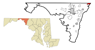
Wilson-Conococheague is a census-designated place (CDP) in Washington County, Maryland, United States. The population was 2,262 at the 2020 census.

<span class="mw-page-title-main">Lakeland Village, California</span> Census-designated place in California, United States

Lakeland Village is a census-designated place (CDP) in Riverside County, California, United States. The population was 11,541 at the 2010 census, more than double the 5,626 reported at the 2000 census.

<span class="mw-page-title-main">Beaverdale, Pennsylvania</span> Census-designated place in Pennsylvania, United States

Beaverdale is an unincorporated community and census-designated place (CDP) in Cambria County, Pennsylvania, United States. The population was 1,035 at the 2010 census. Prior to that time, the CDP was known as Beaverdale-Lloydell.

<span class="mw-page-title-main">Kennebunk (CDP), Maine</span> Census-designated place in Maine, United States

Kennebunk is a census-designated place (CDP) comprising the central village in the town of Kennebunk in York County, Maine, United States. The population was 5,214 at the 2010 census, out of a total town population of 10,798. It is part of the Portland–South Portland–Biddeford, Maine Metropolitan Statistical Area.

<span class="mw-page-title-main">Brimfield (CDP), Ohio</span> CDP in Ohio, United States

Brimfield is a census-designated place (CDP) in Portage County, Ohio, United States. As of the 2020 census, the CDP had a population of 3,365. It is located in the central part of Brimfield Township, a rural area between the Ohio cities of Akron and Kent with light industry, strip-malls, subdivisions, and farms.

<span class="mw-page-title-main">Clearbrook, New Jersey</span> Populated place in Middlesex County, New Jersey, US

Clearbrook is a gated community and census-designated place (CDP) located in Monroe Township, Middlesex County, in the U.S. state of New Jersey. It is in the western part of the township, bordered to the north by Encore at Monroe and to the east by Concordia and The Ponds. It is 3.5 miles (5.6 km) southwest of Jamesburg and 5 miles (8 km) northeast of Hightstown.

References

  1. "2020 U.S. Gazetteer Files". United States Census Bureau. Retrieved April 26, 2022.
  2. 1 2 U.S. Geological Survey Geographic Names Information System: Maugansville, Maryland
  3. "Census of Population and Housing". Census.gov. Retrieved June 4, 2016.
  4. "U.S. Census website". United States Census Bureau . Retrieved January 31, 2008.