
Washington County is located in the western part of the U.S. state of Maryland. As of the 2010 census, the population was 147,430. Its county seat is Hagerstown. Washington County was the first county in the United States to be named for the Revolutionary War general George Washington. Washington County is one of three Maryland counties recognized by the Appalachian Regional Commission as being part of Appalachia.

Cumberland is a city in and the county seat of Allegany County, Maryland, United States. It is the primary city of the Cumberland, MD-WV Metropolitan Statistical Area. At the 2010 census, the city had a population of 20,859, and the metropolitan area had a population of 103,299. Located on the Potomac River, Cumberland is a regional business and commercial center for Western Maryland and the Potomac Highlands of West Virginia.

Western Maryland is the portion of the U.S. state of Maryland that typically consists of Washington, Allegany, and Garrett counties. The region is bounded by the Mason-Dixon line to the north, Preston County, West Virginia to the west, and the Potomac River to the south, which at one point, at the town of Hancock the two boundaries are separated by 1.8 miles.

The Great Allegheny Passage (GAP) is a rail trail system in Maryland and Pennsylvania—the central trail of a network of long-distance hiker-biker trails throughout the Allegheny region of the Appalachian Mountains, connecting Washington, D.C. to Pittsburgh, Pennsylvania. It consists of several smaller trails including the Allegheny Highlands Trail of Maryland, the Allegheny Highlands Trail of Pennsylvania and the Youghiogheny River Trail.

The Western Maryland Railway was an American Class I railroad (1852–1983) which operated in Maryland, West Virginia, and Pennsylvania. It was primarily a coal hauling and freight railroad, with a small passenger train operation.
Blue Ridge Summit is an unincorporated community and census-designated place in Franklin County, Pennsylvania, United States, southwest of Gettysburg in the central part of the state, adjoining Pennsylvania's southern border with Maryland. It is less than 3 miles (5 km) east of Pen Mar, Maryland. The population of Blue Ridge Summit was 891 at the 2010 census.
The Potomac Highlands of West Virginia centers on five West Virginian counties in the upper Potomac River watershed in the western portion of the state's Eastern Panhandle, bordering Maryland and Virginia. Because of geographical proximity, similar topography and landscapes, and shared culture and history, the Potomac Highlands region also includes Pocahontas, Randolph, and Tucker counties, even though they are in the Monongahela River or New River watersheds and not that of the Potomac River.

Ohiopyle State Park is a Pennsylvania state park on 19,052 acres (7,710 ha) in Dunbar, Henry Clay and Stewart Townships, Fayette County, Pennsylvania in the United States. The focal point of the park is the more than 14 miles (23 km) of the Youghiogheny River Gorge that passes through the park. The river provides some of the best whitewater boating in the Eastern United States. Ohiopyle State Park is bisected by Pennsylvania Route 381 south of the Pennsylvania Turnpike. The park opened to the public in 1965, but was not officially dedicated until 1971.
The Appalachian National Scenic Trail spans fourteen U.S. states during its roughly 2,200 miles (3,500 km)-long journey: Georgia, North Carolina, Tennessee, Virginia, West Virginia, Maryland, Pennsylvania, New Jersey, New York, Connecticut, Massachusetts, Vermont, New Hampshire, and Maine. The southern end is at Springer Mountain, Georgia, and it follows the ridgeline of the Appalachian Mountains, crossing many of its highest peaks and running almost continuously through wilderness before reaching the northern end at Mount Katahdin, Maine.
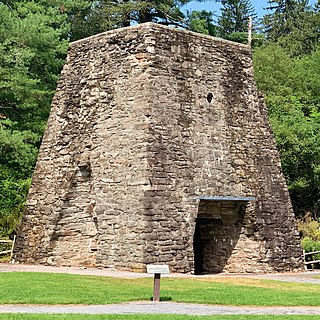
Pine Grove Furnace State Park is a protected Pennsylvania area that includes Laurel and Fuller Lakes in Cooke Township of Cumberland County. The Park accommodates various outdoor recreation activities, protects the remains of the Pine Grove Iron Works (1764), and was the site of Laurel Forge (1830), Pine Grove Park (1880s), and a brick plant (1892). The Park is 8 miles (13 km) from exit 37 of Interstate 81 on Pennsylvania Route 233.

Wills Mountain is a quartzite-capped ridge in the Ridge and Valley physiographic province of the Appalachian Mountains in Pennsylvania and Maryland, United States, extending from near Bedford, Pennsylvania, to near Cumberland, Maryland. It is the northernmost of several mountain ridges included within the Wills Mountain Anticline.
U.S. Route 40 in the U.S. state of Maryland runs from Garrett County in Western Maryland to Cecil County in the state's northeastern corner. With a total length of 221 miles (356 km), it is the longest numbered highway in Maryland. Almost half of the road overlaps or parallels with Interstate 68 (I-68) or I-70, while the old alignment is generally known as US 40 Alternate, US 40 Scenic, or Maryland Route 144. West of Baltimore, in the Piedmont and Appalachian Mountains / Blue Ridge region of the Western Maryland panhandle of the small state, the portions where it does not overlap an Interstate highway are mostly two-lane roads. The portion northeast of Baltimore going toward Wilmington in northern Delaware and Philadelphia in southeastern Pennsylvania is a four-lane divided highway, known as the Pulaski Highway. This section crosses the Susquehanna River at the north end of the Chesapeake Bay on the Thomas J. Hatem Memorial Bridge.

South Mountain State Park is a public recreation area that runs for nearly the entire length of South Mountain through Washington and Frederick counties in Maryland. The state park is contiguous with several other national, state and local parks on the mountain, including the Chesapeake and Ohio Canal National Historical Park, Gathland State Park, Washington Monument State Park, Greenbrier State Park and Pen Mar County Park.

Hagerstown is a city in Washington County, Maryland, United States and the county seat of Washington County. The population of Hagerstown city proper at the 2010 census was 39,662, and the population of the Hagerstown-Martinsburg Metropolitan Area was 269,140. Hagerstown ranks as Maryland's sixth-largest incorporated city.

Sabillasville is an unincorporated community and census-designated place in Frederick County, Maryland, United States. As of the 2010 census it had a population of 354.
Maryland Route 550 is a state highway in the U.S. state of Maryland. The state highway runs 24.43 miles (39.32 km) from MD 26 in Libertytown north to Pen Mar Road in Fort Ritchie. MD 550 runs southeast–northwest across central Frederick County, connecting Fort Ritchie in the northeastern corner of Washington County and Libertytown with the towns of Thurmont and Woodsboro and the smaller communities of Creagerstown and Sabillasville. South of the highway's junction with U.S. Route 15 in Thurmont, the state highway passes through the wide valley of the Monocacy River; to the north, the highway passes along the northern edge of Catoctin Mountain and crests South Mountain near Blue Ridge Summit, Pennsylvania.

Pen Mar Park is a scenic area in Pen Mar, Washington County, Maryland. It is located on High Rock Road adjacent to the Mason–Dixon line. In 1877, the site was opened as an amusement park and resort area by the Western Maryland Railway (WM). During the summer months the railroad offered frequent train service on its "Blue Mountain Express" from Baltimore to Pen Mar. The WM also ran trains from Hagerstown, Maryland to Pen Mar.

Monterey, Pennsylvania, is an unincorporated community which was added to the USGS Geographic Names Information System on August 2, 1979. After the site was surveyed c. 1839 for the never-completed Tapeworm Railroad, the summit community was settled on the Emmitsburg & Waynesboro Turnpike east of the Nichol's Gap Road intersection near the Toll Gate and Brown's Spring and later bypassed by the 20th century Pennsylvania Route 16 highway.


