Mount Lena, Maryland

Last updated

Mount Lena, Maryland
CDP
Washington County Maryland Incorporated and Unincorporated areas Mount Lena Highlighted.svg
Location of Mount Lena, Maryland
Coordinates: 39°33′25″N77°37′25″W / 39.55694°N 77.62361°W / 39.55694; -77.62361
CountryUnited States
State Maryland
County Washington
Area
[1]
  Total1.25 sq mi (3.25 km2)
  Land1.25 sq mi (3.25 km2)
  Water0.00 sq mi (0.00 km2)
Elevation
597 ft (182 m)
Population
 (2020)
  Total547
  Density436.55/sq mi (168.54/km2)
Time zone UTC−5 (Eastern (EST))
  Summer (DST) UTC−4 (EDT)
ZIP code
21713 [2]
Area code(s) 240 and 301
FIPS code 24-54125
GNIS feature ID0590837

Mount Lena is a census-designated place (CDP) in Washington County, Maryland, United States. The population was 501 at the 2000 census.

Contents

Geography

Mount Lena is located at 39°33′25″N77°37′25″W / 39.55694°N 77.62361°W / 39.55694; -77.62361 (39.557063, 77.623662). [3]

According to the United States Census Bureau, the CDP has a total area of 1.2 square miles (3.1 km2), all land.

Demographics

Historical population
CensusPop.Note
2020 547
U.S. Decennial Census [4]

As of the census [5] of 2000, there were 501 people, 199 households, and 154 families residing in the CDP. The population density was 403.0 inhabitants per square mile (155.6/km2). There were 212 housing units at an average density of 170.5 per square mile (65.8/km2). The racial makeup of the CDP was 98.80% White, 0.60% African American, 0.40% Native American and 0.20% Asian. Hispanic or Latino of any race were 0.20% of the population.

There were 199 households, out of which 26.1% had children under the age of 18 living with them, 65.8% were married couples living together, 6.5% had a female householder with no husband present, and 22.6% were non-families. 19.1% of all households were made up of individuals, and 10.6% had someone living alone who was 65 years of age or older. The average household size was 2.52 and the average family size was 2.84.

In the CDP, the population was spread out, with 19.6% under the age of 18, 6.2% from 18 to 24, 29.7% from 25 to 44, 26.3% from 45 to 64, and 18.2% who were 65 years of age or older. The median age was 41 years. For every 100 females, there were 101.2 males. For every 100 females age 18 and over, there were 99.5 males.

The median income for a household in the CDP was $41,932, and the median income for a family was $43,125. Males had a median income of $32,344 versus $26,477 for females. The per capita income for the CDP was $20,844. None of the families and 1.9% of the population were living below the poverty line, including no under eighteens and 12.0% of those over 64.

Related Research Articles

<span class="mw-page-title-main">Lake Louise, Alaska</span> Census-designated place in Alaska, United States

Lake Louise is a census-designated place (CDP) in Matanuska-Susitna Borough, Alaska, United States. Although it is an isolated settlement and is close to Glennallen, it is considered part of the Anchorage Metropolitan Area, like all other locations in the Mat-Su Borough. At the 2020 census the population was 15, down from 46 in 2010 and 88 in 2000.

<span class="mw-page-title-main">Kaʻaʻawa, Hawaii</span> Census-designated place in the United States

Kaʻaʻawa is a small community and census-designated place (CDP) located in the windward district of Koʻolauloa, City & County of Honolulu on the island of Oʻahu, Hawaiʻi, United States. As of the 2010 Census, the total population for Kaʻaʻawa was 1,379. In Hawaiian, kaʻaʻawa means "the wrasse (fish)". From the Hawaiian spelling Kaʻaʻawa it is seen that each a is pronounced separately and distinctly, set apart by the two ʻokinas: [ˈkɐʔəˈʔɐvə] or [ˈkɐʔəˈʔɐwə].

<span class="mw-page-title-main">Star City, Indiana</span> Census-designated place in Indiana, United States

Star City is a census-designated place (CDP) in Van Buren Township, Pulaski County, in the U.S. state of Indiana. The population was 344 at the 2010 census.

<span class="mw-page-title-main">Green Valley, Maryland</span> Census-designated place in Maryland

Green Valley is an unincorporated area and census-designated place (CDP) in southern Frederick County, Maryland, United States. The population was 12,643 at the 2020 census. The area was listed as a census-designated place in 2000 but not listed as part of any CDP at the 2010 census. It was re-designated a census-designated place for the 2020 census.

<span class="mw-page-title-main">Chewsville, Maryland</span> CDP in Maryland, United States

Chewsville is a census-designated place (CDP) in Washington County, Maryland, United States. The population was 293 at the 2000 census.

<span class="mw-page-title-main">Halfway, Maryland</span> CDP in Maryland, United States

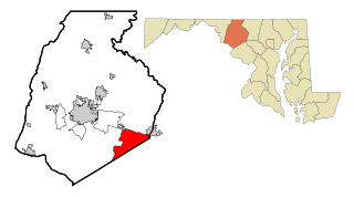
Halfway is a census-designated place (CDP) in Washington County, Maryland, United States. The population was 11,896 at the 2020 census. It is named due to its location, which is halfway between Hagerstown and Williamsport. As a major suburb of Hagerstown, Halfway is part of the Hagerstown-Martinsburg, MD-WV, Metropolitan Statistical Area.

<span class="mw-page-title-main">Highfield-Cascade, Maryland</span> CDP in Maryland, United States

Highfield-Cascade is a census-designated place (CDP) in Washington County, Maryland, United States. The CDP encompasses two closely-spaced unincorporated communities, Highfield and Cascade, which are usually referred to separately. The population of the combined CDP was 1,141 at the 2000 census.

<span class="mw-page-title-main">Maugansville, Maryland</span> CDP in Maryland, United States

Maugansville is a census-designated place (CDP) in Washington County, Maryland, United States. The population was 2,295 at the 2000 census.

<span class="mw-page-title-main">Mount Aetna, Maryland</span> CDP in Maryland, United States

Mount Aetna is a census-designated place (CDP) in Washington County, Maryland, United States. The population was 838 at the 2000 census.

<span class="mw-page-title-main">Robinwood, Maryland</span> CDP in Maryland, United States

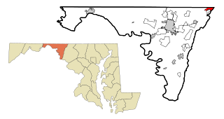
Robinwood is a census-designated place (CDP) in Washington County, Maryland, United States. The population was 4,731 at the 2000 census. It is a part of the Hagerstown Metropolitan Area. Robinwood is home to Hagerstown Community College.

<span class="mw-page-title-main">San Mar, Maryland</span> CDP in Maryland, United States

San Mar is a census-designated place (CDP) in Washington County, Maryland, United States. The population was 515 at the 2000 census.

<span class="mw-page-title-main">St. James, Maryland</span> CDP in Maryland, United States

St. James is a census-designated place (CDP) in Washington County, Maryland, United States. The population was 1,657 at the 2000 census. It is also the home of St. James School, Hagerstown, a small, Episcopalian, boarding school. St. James was formerly named "Lydia."

<span class="mw-page-title-main">Havre North, Montana</span> Census-designated place in Montana, United States

Havre North is a census-designated place (CDP) in Hill County, Montana, United States. The population was 716 at the 2010 census, down from 973 in 2000.

<span class="mw-page-title-main">Acomita Lake, New Mexico</span> Census-designated place in New Mexico, United States

Acomita Lake is a census-designated place (CDP) in Cibola County, New Mexico, United States. The population was 339 at the 2020 census.

<span class="mw-page-title-main">Lake Erie Beach, New York</span> Census-designated place in New York, United States

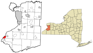
Lake Erie Beach is a hamlet and census-designated place (CDP) in the town of Evans, Erie County, New York, United States. The population was 3,872 at the 2010 census. It is part of the Buffalo–Niagara Falls Metropolitan Statistical Area.

<span class="mw-page-title-main">Mount Repose, Ohio</span> Census-designated place in Ohio, United States

Mount Repose is a census-designated place (CDP) in Miami Township, Clermont County, Ohio, United States. The population was 4,648 at the 2020 census.

<span class="mw-page-title-main">Lake Heritage, Pennsylvania</span> Census-designated place in Pennsylvania, United States

Lake Heritage is a census-designated place (CDP) in Adams County, Pennsylvania, United States. Its population was 2,158 at the 2020 census.

<span class="mw-page-title-main">St. Paul, San Patricio County, Texas</span> Place in Texas, United States

St. Paul is a census-designated place (CDP) in San Patricio County, Texas, United States. The population was 584 at the 2010 census.

<span class="mw-page-title-main">Blennerhassett, West Virginia</span> CDP in West Virginia, United States

Blennerhassett is a census-designated place (CDP) in Wood County, West Virginia, United States. It is part of the Parkersburg-Marietta-Vienna, WV-OH Metropolitan Statistical Area. The population was 3,089 at the 2010 census.

Mexico is a census-designated place (CDP) in the town of Mexico in Oxford County, Maine, United States. The population was 1,946 at the 2000 census.

References

  1. "2020 U.S. Gazetteer Files". United States Census Bureau. Retrieved April 26, 2022.
  2. "Mount Lena MD ZIP Code". zipdatamaps.com. 2023. Retrieved April 18, 2023.
  3. "US Gazetteer files: 2010, 2000, and 1990". United States Census Bureau. February 12, 2011. Retrieved April 23, 2011.
  4. "Census of Population and Housing". Census.gov. Retrieved June 4, 2016.
  5. "U.S. Census website". United States Census Bureau . Retrieved January 31, 2008.