Related Research Articles

Albemarle County is a county located in the Piedmont region of the Commonwealth of Virginia. Its county seat is Charlottesville, which is an independent city and enclave entirely surrounded by the county. Albemarle County is part of the Charlottesville Metropolitan Statistical Area. As of the 2010 census, the population was 98,970, in 2018, it was estimated at 108,718.

Sand Lake is a town in south-central part of Rensselaer County, New York, United States. Sand Lake is east of Albany, New York. Within the town are three hamlets: Averill Park, Glass Lake and the hamlet of Sand Lake. Its four lakes are a source of recreation. Many commercial enterprises of the 19th century and into the 20th century relied on power generated from the Wynants Kill Creek and Burden Lake mills. The area is known for fertile soil for grazing and agriculture. The estimated census for 2016 census is 8,490.
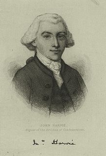
John Harvie, often known as Colonel John Harvie, was an American lawyer and builder from Virginia. He was a delegate to the Second Continental Congress, where he signed the Articles of Confederation, in 1777 and 1778. He was a successful lawyer and landowner, as well as the fourth mayor of Richmond, Virginia. Thomas Jefferson was a friend since his childhood; his father was Jefferson's guardian. He negotiated a peace treaty in 1774 after the Battle of Point Pleasant. During the American Revolutionary War, he was on the Board of War and operated a prison of war camp on his property, The Barracks.

The Nottoway River is a river in the U.S. State of Virginia and northeastern North Carolina that is 155 miles in length. It begins in Prince Edward County and flows to create the Chowan River. The river is part of the Chowan River system, which flows into Albemarle Sound in North Carolina.

Buildings, sites, districts, and objects in Virginia listed on the National Register of Historic Places:
Marshyhope Creek is a 37.0-mile-long (59.5 km) tributary of the Nanticoke River on the Delmarva Peninsula. It rises in Kent County, Delaware, and runs through Caroline County, Maryland, and Dorchester County, Maryland.

Michie Tavern, located in Albemarle County, Virginia, is a Virginia Historic Landmark that was established in 1784 by Scotsman William Michie, though in Earlysville. The Tavern served as the social center of its community and provided travelers with food, drink and lodging. It remained in operation, in the Michie family, until 1910, when it came to be owned by the Commonwealth of Virginia. In 1927, the Tavern was purchased by the Josephine Henderson, who had it moved seventeen miles from Earlysville to its present location, close to Monticello.

Crabtree Creek is a tributary of the Neuse River in central Wake County, North Carolina, United States. The creek begins in the town of Cary and flows through Morrisville, William B. Umstead State Park, and the northern sections of Raleigh before emptying into the Neuse at Anderson Point Park, a large city park located in East Raleigh.

Earlysville is an unincorporated community in Albemarle County, Virginia, United States, roughly 9 miles (14 km) north of Charlottesville. It is named for John Early (1773–1833), father of Confederate general Jubal Early. In 1822, John Early bought just under 1,000 acres (4 km2) of land that now comprise a portion of the town. Earlysville has a small central business district, with a grocery store, restaurant, dentist, daycare, mechanic, and several retail stores. As of January 2019 there remains only a thrift store, an auto repair shop, a United States Post Office, and many churches. There is a nearby light industrial park and several small suburban developments. The bulk of the area is rural in character.

The Little Nottoway River is a 14.31 mi (23.03 km) long tributary to the Nottoway River in the United States state of Virginia. Located in the southeastern part of the state, it is part of the larger Chowan-Albemarle drainage.
Three Creek is a nearly 47 mile (75.4 km) long tributary of the Nottoway River in southeastern Virginia in the United States.

Buck Mountain Episcopal Church is a historic Episcopal church on VA 743, northwest of the junction with VA 633 in Earlysville, Virginia. It is a rare surviving example of the simple wooden Anglican parish churches scattered through Virginia in the colonial period, and is considered one of the finest surviving examples of rural Virginia Greek Revival churches. One of three churches erected to serve Frederick Parish, the original building was completed between 1747 and 1750. The church was moved to its present site in 1860. Buck Mountain is now a parish church in the Episcopal Diocese of Virginia.
The Whetstone Creek is a 10.54 mi (16.96 km) long tributary to the Little Nottoway River in the United States state of Virginia. Located in the southeastern part of the state, it is part of the larger Chowan-Albemarle drainage. The watershed is 65% forested and 32% agricultural with the rest of land as other uses.
Lazaretto Creek is a 8.89 mi (14.31 km) long tributary to the Little Nottoway River in the United States state of Virginia. Located in the south-central part of the state, it is part of the larger Chowan-Albemarle drainage. The watershed is 51% forested and 39% agricultural with the rest of land as other uses.
The Mallorys Creek is a 7.10 mi (11.43 km) long tributary to the Little Nottoway River in the United States state of Virginia. Located in the south-central part of the state, it is part of the larger Chowan-Albemarle drainage. The watershed is 54% forested and 39% agricultural with the rest of land as other uses. This stream joins with Carys Creek to form the Little Nottoway River.
Carys Creek is a 7.06 mi (11.36 km) long tributary to the Little Nottoway River in the United States state of Virginia. Located in the south-central part of the state, it is part of the larger Chowan-Albemarle drainage. The watershed is 74% forested and 25% agricultural with the rest of land as other uses. This stream joins with Carys Creek to form the Little Nottoway River.
Horsepen Creek is a 6.56 mi (10.56 km) long tributary to the Little Nottoway River in the United States state of Virginia. Located in the south-central part of the state, it is part of the larger Chowan-Albemarle drainage. The watershed is 66% forested and 32% agricultural with the rest of land as other uses.

Wickersham Dome is a summit in the Yukon–Koyukuk Census Area, Alaska, located 27 miles northwest of Fairbanks near the Elliott Highway. It is named after Wickersham Creek, which heads on the southeast slope of Wickersham Dome. The creek itself is named for James Wickersham.

Belmont Plantation, also known as Belmont Estate and Belmont, is a locale in Albemarle County, Virginia, and the site of a 19th-century plantation. It was among the first patents in Albemarle County, patented in the 1730s. Matthew Graves sold a 2,500-acre-tract to John Harvie Sr., a friend of Peter Jefferson and a guardian of Thomas Jefferson. After his death in 1767, the property was inherited by his son John Harvie, Jr. Harvie lived at Belmont for several years, but after he was appointed the Registrar of Land Grants, he moved to Richmond, Virginia and John Rogers oversaw the plantation. Rogers was known for his progressive approaches to agriculture, including methods for improving the quality of the soil after years of tobacco crops.
John Rogers was an overseer of three plantations, including Thomas Jefferson's Monticello. He then owned and operated the East Belmont plantation. Rogers was a co-founder of the Albemarle Agricultural Society, and was known for his revolutionary agricultural reforms. His influence and knowledge-gathering was centered among planters in Albemarle County, as well as across the country and in Europe.
References
- 1 2 "GNIS Detail - Buck Mountain". geonames.usgs.gov. Retrieved 2021-05-01.
- ↑ Woods, Edgar (1901). Albemarle County in Virginia: Giving Some Account of what it was by Nature, of what it was Made by Man, and of Some of the Men who Made it. Michie Company, printers. p. 20. ISBN 978-0-243-75970-5.
- ↑ "Buck Mountain, topographical map". topozone. Retrieved 2021-05-01.
- 1 2 "Original Location of Buck Mountain Episcopal Church". Buck Mountain Episcopal Church. Retrieved 2021-05-01.
- ↑ "Buck Mountain Church". www.visitcharlottesville.org. Retrieved 2021-05-01.
- 1 2 3 4 "Buck Mountain Creek Cemetery". www2.vcdh.virginia.edu. Retrieved 2021-05-01.
- ↑ "GNIS Detail - Buck Mountain Cemetery". geonames.usgs.gov. Retrieved 2021-05-01.
- ↑ "Cemetery Map: Buck Mountain Creek Cemetery". www2.vcdh.virginia.edu. Retrieved 2021-05-01.
- 1 2 "The Meadow Run Grist Mill Historical Marker". www.hmdb.org. Retrieved 2021-05-01.
- ↑ "GNIS Detail - Buck Mountain Creek". geonames.usgs.gov. Retrieved 2021-05-01.
Coordinates: 38°11′36.48″N78°33′49.05″W / 38.1934667°N 78.5636250°W