Mount Jefferson (Virginia)

Last updated
Mount Jefferson
USA Virginia location map.svg
Red triangle with thick white border.svg
Mount Jefferson
Usa edcp relief location map.png
Red triangle with thick white border.svg
Mount Jefferson
Mount Jefferson (the US)
Highest point
Elevation 846 ft (258 m) [1]
Coordinates 38°01′58″N78°31′20″W / 38.03278°N 78.52222°W / 38.03278; -78.52222 Coordinates: 38°01′58″N78°31′20″W / 38.03278°N 78.52222°W / 38.03278; -78.52222 [1]
Geography
Location Albemarle County, Virginia, U.S.
Parent range Ragged Mountains
Topo map USGS Charlottesville West

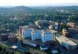
Mount Jefferson is a mountain located just outside Charlottesville, Virginia, United States, in Albemarle County. It lies south of Lewis Mountain, and is positioned at the northeastern edge of the Ragged Mountains.

Mountain A large landform that rises fairly steeply above the surrounding land over a limited area

A mountain is a large landform that rises above the surrounding land in a limited area, usually in the form of a peak. A mountain is generally steeper than a hill. Mountains are formed through tectonic forces or volcanism. These forces can locally raise the surface of the earth. Mountains erode slowly through the action of rivers, weather conditions, and glaciers. A few mountains are isolated summits, but most occur in huge mountain ranges.

Charlottesville, Virginia Independent city in Virginia, United States

Charlottesville, colloquially known as C'ville and officially named the City of Charlottesville, is an independent city in the Commonwealth of Virginia. It is the county seat of Albemarle County, which surrounds the city, though the two are separate legal entities. This means a resident will list Charlottesville as both their county and city on official paperwork. It is named after the British Queen consort Charlotte of Mecklenburg-Strelitz, who as the wife of George III was Virginia's last Queen. In 2016, an estimated 46,912 people lived within the city limits. The Bureau of Economic Analysis combines the City of Charlottesville with Albemarle County for statistical purposes, bringing its population to approximately 150,000. Charlottesville is the heart of the Charlottesville metropolitan area, which includes Albemarle, Buckingham, Fluvanna, Greene, and Nelson counties.

Albemarle County, Virginia County in the United States

Albemarle County is a county located in the Piedmont region of the Commonwealth of Virginia. Its county seat is Charlottesville, which is an independent city and enclave entirely surrounded by the county. Albemarle County is part of the Charlottesville Metropolitan Statistical Area. As of the 2010 census, the population of Albemarle County was 98,970, more than triple the 1960 census count.

It was named Mount Jefferson in honor of Thomas Jefferson after the establishment of the Leander McCormick Observatory on the summit in 1885. Jefferson had urged the purchase of the mountain for the University of Virginia, in part because of its suitability as a site for an observatory. In addition, he valued it for the water resources and the abundance of timber for construction of the university.

Thomas Jefferson 3rd president of the United States

Thomas Jefferson was an American statesman, diplomat, lawyer, architect, and Founding Father who served as the third president of the United States from 1801 to 1809. Previously, he had served as the second vice president of the United States from 1797 to 1801. The principal author of the Declaration of Independence, Jefferson was a proponent of democracy, republicanism, and individual rights, motivating American colonists to break from the Kingdom of Great Britain and form a new nation; he produced formative documents and decisions at both the state and national level.

University of Virginia University in Charlottesville, Virginia, United States

The University of Virginia is a public research university in Charlottesville, Virginia. It was founded in 1819 by Declaration of Independence author and former President Thomas Jefferson. UVA is the flagship university of Virginia and a UNESCO World Heritage Site. It is known for its historic foundations, student-run honor code, and secret societies.

Water chemical compound

Water is a transparent, tasteless, odorless, and nearly colorless chemical substance, which is the main constituent of Earth's streams, lakes, and oceans, and the fluids of most living organisms. It is vital for all known forms of life, even though it provides no calories or organic nutrients. Its chemical formula is H2O, meaning that each of its molecules contains one oxygen and two hydrogen atoms, connected by covalent bonds. Water is the name of the liquid state of H2O at standard ambient temperature and pressure. It forms precipitation in the form of rain and aerosols in the form of fog. Clouds are formed from suspended droplets of water and ice, its solid state. When finely divided, crystalline ice may precipitate in the form of snow. The gaseous state of water is steam or water vapor. Water moves continually through the water cycle of evaporation, transpiration (evapotranspiration), condensation, precipitation, and runoff, usually reaching the sea.

Prior to the renaming it had been known as Old Reservoir Mountain and Observatory Mountain (for an observatory which Jefferson directed to be built on the summit), and is now informally known as Observatory Hill.

The mountain is traversed by McCormick Road and Edgemont Road (which also runs along a neighboring ridge — Edgemont or Midmont), and is the site of several other University of Virginia buildings including a deactivated nuclear reactor, a linear accelerator and dormitories. It has been preserved in a largely wooded state for the protection of McCormick Observatory from light pollution. It is used by birdwatchers, mountain bikers, hikers, and students and faculty at The Judge Advocate General's Legal Center and School, U.S. Army, for military physical fitness training. The headquarters for the National Radio Astronomy Observatory are also located on Mount Jefferson.

Nuclear reactor device to initiate and control a sustained nuclear chain reaction

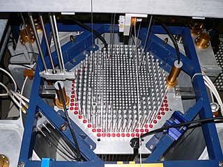
A nuclear reactor, formerly known as an atomic pile, is a device used to initiate and control a self-sustained nuclear chain reaction. Nuclear reactors are used at nuclear power plants for electricity generation and in nuclear marine propulsion. Heat from nuclear fission is passed to a working fluid, which in turn runs through steam turbines. These either drive a ship's propellers or turn electrical generators' shafts. Nuclear generated steam in principle can be used for industrial process heat or for district heating. Some reactors are used to produce isotopes for medical and industrial use, or for production of weapons-grade plutonium. Research reactors are run only for research. As of early 2019, the IAEA reports there are 454 nuclear power reactors and 226 nuclear research reactors in operation around the world.

Forest dense collection of trees covering a relatively large area

A forest is a large area dominated by trees. Hundreds of more precise definitions of forest are used throughout the world, incorporating factors such as tree density, tree height, land use, legal standing and ecological function. According to the widely used Food and Agriculture Organization definition, forests covered 4 billion hectares (9.9×10⁹ acres) (15 million square miles) or approximately 30 percent of the world's land area in 2006.

Light pollution presence of anthropogenic light in the night environment, exacerbated by excessive, misdirected or obtrusive uses of light, blamed for compromising health, disrupting ecosystems and spoiling aesthetic environments

Light pollution, also known as photopollution, is the presence of anthropogenic light in the night environment. It is exacerbated by excessive, misdirected or obtrusive uses of light, but even carefully used light fundamentally alters natural conditions. As a major side-effect of urbanization, it is blamed for compromising health, disrupting ecosystems and spoiling aesthetic environments.

Related Research Articles

Mount Erebus volcano on Ross Island, Antarctica

Mount Erebus is the second-highest volcano in Antarctica and the southernmost active volcano on Earth. It is the sixth-highest ultra mountain on the continent. With a summit elevation of 3,794 metres (12,448 ft), it is located in the Ross Dependency on Ross Island, which is also home to three inactive volcanoes: Mount Terror, Mount Bird, and Mount Terra Nova.

Mount Bachelor volcano

Mount Bachelor, formerly named Bachelor Butte, is a stratovolcano atop a shield volcano in the Cascade Volcanic Arc and the Cascade Range of central Oregon. Named Mount Bachelor because it "stands apart" from the nearby Three Sisters, it lies in the eastern segment of the central portion of the High Cascades, the eastern segment of the Cascade Range. The volcano lies at the northern end of the 15-mile (24 km) long Mount Bachelor Volcanic Chain, which underwent four major eruptive episodes during the Pleistocene and the Holocene. The United States Geological Survey considers Mount Bachelor a moderate threat, but Bachelor poses little threat of becoming an active volcano in the near future. It remains unclear whether the volcano is extinct or just inactive.

Mount Jefferson is a mountain located in Ashe County, North Carolina. The mountain is part of the Mount Jefferson State Natural Area. The mountain has an elevation of 4,665 feet (1,422 m) above sea level, and it sharply rises more than 1,600 feet above the towns of Jefferson, North Carolina and West Jefferson.

Mount Jefferson (New Hampshire) mountain in Coos County, New Hampshire

Mount Jefferson is located in Coos County, New Hampshire, and is the third highest mountain in the state. The mountain is named after Thomas Jefferson, the third president of the United States, and is part of the Presidential Range of the White Mountains. Mount Jefferson is flanked by Mount Adams and Mount Clay.

Churchill Mountains mountain range in Antarctica

The Churchill Mountains are a mountain range group of the Transantarctic Mountains System, located in the Ross Dependency region of Antarctica. They border on the western side of the Ross Ice Shelf, between Byrd Glacier and Nimrod Glacier.

Mount Hamilton (California) mountain in United States of America

Mount Hamilton is a mountain in California's Diablo Range, in Santa Clara County, California. Mount Hamilton, at 4,265 feet (1,300 m) is a mountain overlooking Santa Clara Valley and is the site of Lick Observatory, the World's first permanently occupied mountain-topobservatory. The asteroid 452 Hamiltonia, discovered in 1899, is named after the mountain. Golden eagle nesting sites are found on the slopes of Mount Hamilton. On clear days, Mount Tamalpais, the Santa Cruz Mountains, Monterey Bay, the Monterey Peninsula, and even Yosemite National Park are visible from the summit of the mountain.

Mount Griggs mountain

Mount Griggs, formerly known as Knife Peak Volcano, is a stratovolcano, which lies 10 km behind the volcanic arc defined by other Katmai group volcanoes. Although no historic eruptions have been reported from Mount Griggs, vigorously active fumaroles persist in a summit crater and along the upper southwest flank. The fumaroles on the southwest flank are the hottest, and some of the flank fumaroles can roar so loudly that they can be heard from the valley floor. The slopes of Mount Griggs are heavily mantled by fallout from the 1912 eruption of Novarupta volcano. The summit consists of three concentric craters, the lowest and largest of which contains a recent summit cone topped by two craters. The volume of the volcanic edifice is estimated at about 25 cubic kilometres (6.0 cu mi). Isotopic analysis indicates that the source of Griggs' magma is distinct from the other Katmai volcanoes.

Mount Lemmon mountain

Mount Lemmon, with a summit elevation of 9,159 feet (2,792 m), is the highest point in the Santa Catalina Mountains. It is located in the Coronado National Forest north of Tucson, Arizona, United States. Mount Lemmon was named for botanist Sara Plummer Lemmon, who trekked to the top of the mountain with her husband and E. O. Stratton, a local rancher, by horse and foot in 1881. It is reported that Mount Lemmon Ski Valley, on the mountain's northeastern side, receives 200 inches (508 cm) of snow annually.

McCormick Observatory observatory

The Leander McCormick Observatory is one of the astronomical observatories operated by the Department of Astronomy of the University of Virginia and is situated just outside Charlottesville, Virginia (US) in Albemarle County on the summit of Mount Jefferson. It is named for Leander J. McCormick (1819–1900), who provided the funds for the telescope and observatory.

Lake Tear of the Clouds lake in Essex County, New York, USA

Lake Tear of the Clouds is a small tarn located in the town of Keene, in Essex County, New York, United States, on the southwest slope of Mount Marcy, the state's highest point, in the Adirondack Mountains. It is the highest pond in the state. It is often cited as the highest source of the Hudson River, via Feldspar Brook, the Opalescent River and Calamity Brook.

Mount Scott (Oklahoma) mountain in Oklahoma, USA

Mount Scott is a prominent mountain just to the northwest of Lawton, Oklahoma rising to a height of 2,464 feet (751 m). It is located in the Wichita Mountains near Fort Sill Military Reservation and lies in the Wichita Mountains National Wildlife Refuge (WMWR). The US Fish and Wildlife Service is responsible for the maintenance of the area. Visitors can reach the summit by car or bicycle via a three-mile paved road. Hiking is allowed, although there are no formal trails and the paved road is open to pedestrians and bicycles from 6am to 9:30 am only. Mount Scott is also popular for its numerous rock climbing areas. The peak was named in honor of General Winfield Scott.

Dee Wright Observatory

Dee Wright Observatory is an observation structure at the summit of McKenzie Pass in the Cascade Mountains of Oregon. The structure is an open shelter constructed with lava stone. It is located in the midst of a large lava flow, and offers an exceptional view of numerous Cascade peaks.

Lookout Mountain (Colorado) mountain in Colorado, United States

Lookout Mountain is a foothill on the eastern flank of the Front Range of the Rocky Mountains of North America. The 7,377-foot (2,249 m) peak is located in Lookout Mountain Park, 1.7 miles (2.7 km) west-southwest of downtown Golden in Jefferson County, Colorado, United States.

Crow Summit, West Virginia Unincorporated community in West Virginia, United States

Crow Summit is an unincorporated community in Jackson County, West Virginia, United States. Crow Summit is located on County Route 56 6.2 miles (10.0 km) north of Ripley. Crow Summit once had a post office, which is now closed. The community was named after Michael Crow, an original owner of the town site.

References

Geographic Names Information System geographical database

The Geographic Names Information System (GNIS) is a database that contains name and locative information about more than two million physical and cultural features located throughout the United States of America and its territories. It is a type of gazetteer. GNIS was developed by the United States Geological Survey in cooperation with the United States Board on Geographic Names (BGN) to promote the standardization of feature names.

United States Geological Survey Scientific agency of the United States government

The United States Geological Survey is a scientific agency of the United States government. The scientists of the USGS study the landscape of the United States, its natural resources, and the natural hazards that threaten it. The organization has four major science disciplines, concerning biology, geography, geology, and hydrology. The USGS is a fact-finding research organization with no regulatory responsibility.