Floyd County, Virginia

Last updated

Floyd County
Floyd Co CH.jpg
Floyd County Courthouse and Confederate Monument
Flag of Floyd County, Virginia.png
Floyd County Seal.png
Logo of Floyd County, Virginia.svg
Map of Virginia highlighting Floyd County.svg
Location within the U.S. state of Virginia
Virginia in United States.svg
Virginia's location within the U.S.
Coordinates: 36°56′N80°22′W / 36.94°N 80.36°W / 36.94; -80.36
CountryFlag of the United States.svg United States
StateFlag of Virginia.svg  Virginia
Founded1831
Named for John Floyd
Seat Floyd
Largest townFloyd
Area
  Total382 sq mi (990 km2)
  Land381 sq mi (990 km2)
  Water0.9 sq mi (2 km2)  0.2%
Population
 (2020)
  Total15,476 Increase2.svg
  Density41/sq mi (16/km2)
Time zone UTC−5 (Eastern)
  Summer (DST) UTC−4 (EDT)
Congressional district 9th
Website www.floydcova.org

Floyd County is a county located in the Commonwealth of Virginia. As of the 2020 census, the population was 15,476. [1] Its county seat is the town of Floyd. [2] Floyd County is included in the Blacksburg-Christiansburg, VA Metropolitan Statistical Area. Named after Virginia politician John Floyd, the county was established in 1831. The county is located on the high plateau of the Blue Ridge Mountains and surrounded by the Little River. In the 1960s and 1970s, Floyd proved popular with people in the era's counterculture, particularly those who wanted to live in closer contact with nature.

Contents

History

Portrait of John Floyd, for whom Floyd County was named John Floyd (cropped).jpg
Portrait of John Floyd, for whom Floyd County was named

Floyd County's recorded history begins with the arrival of traders, trappers and hunters in Southwest Virginia in the 18th century. The earliest known travel way through present day Floyd County was the Trader's Path, running from east to west across the Roanoke River where Back Creek enters the river, by John Mason's, R. Poage's, the headwaters of Back Creek and southwest over Bent Mountain. The trail continued westward through the Little River area to the Lead Mines.

The first known attempts to settle the area appear to have been made during the 1740s. In 1745 the Virginia Council granted James Patton, of Augusta County, among others, 100,000 acres (400 km2) on the New River and the westward flowing waters, including the Little River area. In 1749 the Royal Company of Virginia also received a grant on the westward flowing waters, putting the two companies in competition with one another to settle the area. The first surveying of the land occurred in the late 1740s. [3]

On January 15, 1831, the General Assembly of Virginia passed an act creating the present county of Floyd out of the county Montgomery. The new county was named for the then Governor of Virginia, John Floyd. [4] The new county's courthouse was completed in 1834. In 1870 a portion of Franklin County was added to Floyd County. The first Commonwealth's Attorney was William Ballard Preston, a nephew of John Floyd, who would later serve as Secretary of the United States Navy. Preston was followed in later years by Jubal Early, who would later serve as a general for the Confederate Army. [5]

Virginia Volunteers Recruitment poster from Floyd County, 1862. American Civil War era. To Arms Confederate Enlistment Poster 1862.jpg
Virginia Volunteers Recruitment poster from Floyd County, 1862. American Civil War era.

The county seat of Floyd County was first called Jacksonville for Andrew Jackson, seventh President of the United States (1829–1837). Jacksonville was first incorporated in 1858 and then re-incorporated on February 19, 1892, to expand the town boundaries. On January 23, 1896, the General Assembly passed an Act officially changing the name of the Town of Jacksonville to the town of Floyd.

The county became a destination for those involved in the counterculture during the 1960s and 1970s, particularly those who wanted to live in closer contact with nature. [6] In the late 1990s, the Rivendell community was established by a group of Christians so they could practice a lifestyle consistent with their Reformed Churches' interpretations of the Bible and also, in part, to be better isolated from possible societal disruptions caused by the year 2000 problem. Most of the original members of this community have moved on. [7]

Floyd County was also a setting for the ministry of Reverend Bob Childress, whose life was chronicled in the book The Man Who Moved a Mountain.

The county's location directly adjacent to both the Roanoke and the Blacksburg-Christiansburg Metropolitan Statistical Areas have contributed to modest population growth in contrast to most rural counties in Southwest Virginia. Several bloggers live in the county and frequently post observations about the community and its rural setting. [8]

Floyd County also has a strong music and literary scene. Three establishments in Floyd regularly offer a variety of live music during the weekends ranging from traditional styles such as Bluegrass and Old-time music to contemporary and alternative acts. Best known is the Friday Night Jamboree held at The Floyd Country Store. [9] Both the Floyd Country Store and County Sales, founded in the 1960s, [10] are featured on the Virginia Heritage Music Trail called "The Crooked Road." [11] In the early 21st century, Floyd became the home of an annual world music festival called FloydFest. Floyd County-based old time string band The Alum Ridge Boys & Ashlee won first prize at the 85th Annual Old Fiddlers' Convention held in Galax, Virginia. [12]

The Chateau Morrisette and Villa Appalaccia wineries have been established since the 1980s.

Geography

Rolling hills of Floyd County. Hills of Floyd County VA USA.JPG
Rolling hills of Floyd County.

According to the United States Census Bureau, the county has a total area of 381.8 square miles (988.9 km2), of which 380.9 square miles (986.5 km2) is land and 0.9 square miles (2.3 km2) (0.2%) is water. [13] It is located in the Blue Ridge Mountains of southwestern Virginia.

The county seat, the town of Floyd, is 40 miles (64 km) southwest of Roanoke on US 221. Buffalo Mountain, at 3,971 feet (1,210 m), is the highest point in the county.

Floyd County is situated atop a high plateau of the Blue Ridge Mountains which divides the eastward flowing from the westward flowing waters. With the high topography, no streams flow into Floyd County. The county is drained primarily by Little River and its tributaries which flow into New River below the Claytor Lake Dam and, in turn, by way of the Kanawha River, the Ohio River and the Mississippi River, into the Gulf of Mexico.

The Little River, the county's largest waterway, is formed by three main branches, or forks: the East, West, and South (also known as Dodd's Creek). It is said that no water flows into Floyd County. [14]

The headwaters of the south fork of the Roanoke River are in the northeastern part of the county. One particular fast stream is Shooting Creek, named for its speed over rocks. This creek today follows Shooting Creek Road from Floyd into Franklin County. In was once the site of moonshine liquor distilleries and the lawlessness that surrounded this industry.

Adjacent counties

Protected areas

Major highways

Demographics

Historical population
CensusPop.Note
1840 4,453
1850 6,45845.0%
1860 8,23627.5%
1870 9,82419.3%
1880 13,25534.9%
1890 14,4058.7%
1900 15,3886.8%
1910 14,092−8.4%
1920 13,115−6.9%
1930 11,698−10.8%
1940 11,9672.3%
1950 11,351−5.1%
1960 10,462−7.8%
1970 9,775−6.6%
1980 11,56318.3%
1990 12,0053.8%
2000 13,87415.6%
2010 15,27910.1%
2020 15,4761.3%
U.S. Decennial Census [15]
1790-1960 [16] 1900-1990 [17]
1990-2000 [18] 2010 [19] 2020 [20]

2020 census

Floyd County, Virginia – Racial and ethnic composition
Note: the US Census treats Hispanic/Latino as an ethnic category. This table excludes Latinos from the racial categories and assigns them to a separate category. Hispanics/Latinos may be of any race.
Race / Ethnicity (NH = Non-Hispanic)Pop 2010 [19] Pop 2020 [20] % 2010% 2020
White alone (NH)14,38514,11494.15%91.20%
Black or African American alone (NH)2702341.771.51%
Native American or Alaska Native alone (NH)19180.12%0.12%
Asian alone (NH)35460.23%0.30%
Pacific Islander alone (NH)100.01%0.00%
Some Other Race alone (NH)16720.10%0.47%
Mixed Race or Multi-Racial (NH)1415050.92%3.26%
Hispanic or Latino (any race)4124872.70%3.15%
Total15,27915,476100.00%100.00%

2000 census

As of the census [21] of 2000, there were 13,874 people, 5,791 households, and 4,157 families residing in the county. The population density was 36 people per square mile (14 people/km2). There were 6,763 housing units at an average density of 18 units per square mile (6.9 units/km2). The racial makeup of the county was 96.71% White, 2.00% Black or African American, 0.09% Native American, 0.09% Asian, 0.01% Pacific Islander, 0.36% from other races, and 0.74% from two or more races. 1.35% of the population were Hispanic or Latino of any race.

There were 5,791 households, out of which 29.10% had children under the age of 18 living with them, 59.90% were married couples living together, 8.10% had a female householder with no husband present, and 28.20% were non-families. 24.70% of all households were made up of individuals, and 10.80% had someone living alone who was 65 years of age or older. The average household size was 2.39 and the average family size was 2.83.

In the county, the population was spread out, with 22.20% under the age of 18, 6.90% from 18 to 24, 27.60% from 25 to 44, 27.40% from 45 to 64, and 15.90% who were 65 years of age or older. The median age was 40 years. For every 100 females there were 97.50 males. For every 100 females age 18 and over, there were 96.70 males.

The median income for a household in the county was $31,585, and the median income for a family was $38,128. Males had a median income of $30,886 versus $20,466 for females. The per capita income for the county was $16,345. About 8.50% of families and 11.70% of the population were below the poverty line, including 12.70% of those under age 18 and 15.30% of those age 65 or over.

Communities

Town of Floyd

Other communities:

Government and politics

Floyd County is an anomaly in Virginia politics, being a solidly Republican county even during the height of the Democratic "Solid South". This is due to the fact that the county's inhabitants largely deserted the Confederate army during the Civil War, [22] so that it was one of very few white areas in antebellum slave states to endorse Radical Reconstruction. Over generations, this has translated into powerful party loyalty thereto. Floyd was the only Virginia county to vote for Herbert Hoover against Franklin Roosevelt in 1932, and the last Democrat to carry the county in a presidential election was Winfield S. Hancock in 1880. [23] Theodore Roosevelt did win Floyd County in 1912 as a result of a split in the Republican Party, while Democratic Senatorial candidate Mark Warner carried the county in his landslide 2008 victory.

United States presidential election results for Floyd County, Virginia [24]
Year Republican Democratic Third party
No.%No.%No.%
2020 6,22566.17%3,00431.93%1791.90%
2016 5,29365.75%2,30028.57%4575.68%
2012 4,67361.13%2,73235.74%2393.13%
2008 4,44159.09%2,93739.08%1381.84%
2004 4,16261.81%2,48836.95%841.25%
2000 3,42359.64%1,95734.10%3596.26%
1996 2,37448.07%1,90938.65%65613.28%
1992 2,57548.44%2,02638.11%71513.45%
1988 2,92161.69%1,72736.47%871.84%
1984 3,43167.69%1,59931.54%390.77%
1980 2,44756.60%1,64237.98%2345.41%
1976 2,07152.76%1,72844.03%1263.21%
1972 2,44476.11%70822.05%591.84%
1968 2,27564.32%71520.21%54715.47%
1964 1,83661.51%1,14438.32%50.17%
1960 1,93370.06%81729.61%90.33%
1956 1,97070.46%79928.58%270.97%
1952 1,62671.69%61927.29%231.01%
1948 1,26672.55%43424.87%452.58%
1944 1,42469.06%63030.55%80.39%
1940 1,48266.94%72932.93%30.14%
1936 1,56668.90%69930.75%80.35%
1932 1,05159.99%69939.90%20.11%
1928 1,48177.38%43322.62%00.00%
1924 98465.04%51534.04%140.93%
1920 1,35572.65%49726.65%130.70%
1916 89365.42%47234.58%00.00%
1912 22216.31%40930.05%73053.64%

Board of Supervisors

Constitutional officers

Floyd is represented by Republican David R. Sutterlein in the Virginia Senate, Republican Marie March in the Virginia House of Delegates, and Republican H. Morgan Griffith in the U.S. House of Representatives.

See also

Related Research Articles

<span class="mw-page-title-main">Montgomery County, Virginia</span> County in Virginia, United States

Montgomery County is a county located in the Valley and Ridge area of the U.S. state of Virginia. As population in the area increased, Montgomery County was formed in 1777 from Fincastle County, which in turn had been taken from Botetourt County. As of the 2020 census, the population was 99,721. Its county seat is Christiansburg, and Blacksburg is the largest town. Montgomery County is part of the Blacksburg-Christiansburg metropolitan area. It is dominated economically by the presence of Virginia Tech, Virginia's third largest public university, which is the county's largest employer.

<span class="mw-page-title-main">Wasatch County, Utah</span> County in Utah, United States

Wasatch County is a county in the U.S. state of Utah. As of the 2020 United States Census, the population was 34,788. Its county seat and largest city is Heber City. The county was named for a Ute word meaning "mountain pass" or "low place in the high mountains".

<span class="mw-page-title-main">Roanoke County, Virginia</span> County in Virginia, United States

Roanoke County is a county located in the U.S. state of the Commonwealth of Virginia. As of the 2020 census, the population was 96,929. Its county seat is Salem, but the county administrative offices are located in the census-designated place of Cave Spring.

<span class="mw-page-title-main">Pulaski County, Virginia</span> County in Virginia, United States

Pulaski County is a county located in the southwestern part of the U.S. state of Virginia. As of the 2020 census, the population was 33,800. Its county seat is Pulaski. Pulaski County is part of the Blacksburg–Christiansburg, VA Metropolitan Statistical Area.

<span class="mw-page-title-main">Pittsylvania County, Virginia</span> County in Virginia, United States

Pittsylvania County is a county located in the Commonwealth of Virginia. As of the 2020 United States Census, the population was 60,501. Chatham is the county seat.

<span class="mw-page-title-main">Patrick County, Virginia</span> County in Virginia, United States

Patrick County is a county located on the central southern border of the Commonwealth of Virginia. As of the 2020 census, the county's population was 17,608. Its county seat is Stuart. It is located within both the rolling hills and valleys of the Piedmont Region and the more mountainous regions of Southwest Virginia.

<span class="mw-page-title-main">Grayson County, Virginia</span> County in Virginia, United States

Grayson County is a county located in the southwestern part of the Commonwealth of Virginia. As of the 2020 census, the population was 15,333. Its county seat is Independence. Mount Rogers, the state's highest peak at 5,729 feet (1,746 m), is in Grayson County.

<span class="mw-page-title-main">Galax, Virginia</span> Independent city in Virginia, United States

Galax is an independent city in the southwestern part of the Commonwealth of Virginia. As of the 2020 census, the population was 6,720.

<span class="mw-page-title-main">Franklin County, Virginia</span> County in Virginia, United States

Franklin County is located in the Blue Ridge foothills of the Commonwealth of Virginia. As of the 2020 census, the population was 54,477. Its county seat is Rocky Mount. Franklin County is part of the Roanoke Metropolitan Statistical Area and is located in the Roanoke Region of Virginia. The Roanoke River forms its northeast boundary with Bedford County.

<span class="mw-page-title-main">Craig County, Virginia</span> County in Virginia, United States

Craig County is a county located in the Commonwealth of Virginia. As of the 2020 census, the population was 4,892. Its county seat is New Castle.

<span class="mw-page-title-main">Botetourt County, Virginia</span> County in Virginia, United States

Botetourt County is a US county that lies in the Roanoke Region of Virginia. Located in the mountainous portion of the state, the county is bordered by two major ranges, the Blue Ridge Mountains and the Appalachian Mountains.

<span class="mw-page-title-main">Bedford County, Virginia</span> County in Virginia, United States

Bedford County is a United States county located in the Piedmont region of the Commonwealth of Virginia. Its county seat is the town of Bedford, which was an independent city from 1968 until rejoining the county in 2013.

<span class="mw-page-title-main">Appomattox County, Virginia</span> County in Virginia, United States

Appomattox County is a United States county located in the Piedmont region and near the center of the Commonwealth of Virginia. The county is part of the Lynchburg, VA Metropolitan Statistical Area, and its county seat is the town of Appomattox.

<span class="mw-page-title-main">Amherst County, Virginia</span> County in Virginia, United States

Amherst County is a county, located in the Piedmont region and near the center of the Commonwealth of Virginia in the United States. The county is part of the Lynchburg Metropolitan Statistical Area, and its county seat is also named Amherst.

<span class="mw-page-title-main">Alleghany County, Virginia</span> County in Virginia, United States

Alleghany County is an American county located on the far western edge of Commonwealth of Virginia. It is bordered by the Allegheny Mountains, from which the county derives its name, and it is the northernmost part of the Roanoke Region. The county seat is Covington. As of the 2020 census, the population was 15,223.

<span class="mw-page-title-main">Columbia County, Pennsylvania</span> County in Pennsylvania, United States

Columbia County is a county in the Commonwealth of Pennsylvania. It is located in Northeastern Pennsylvania. As of the 2020 census, the population was 64,727. Its county seat is Bloomsburg. The county was created on March 22, 1813, from part of Northumberland County. It was named Columbia, alluding to the United States and Christopher Columbus.

<span class="mw-page-title-main">Barry County, Missouri</span> County in Missouri, United States

Barry County is a county located in the southwest portion of the U.S. state of Missouri. As of the 2020 Census, the population was 34,534. Its county seat is Cassville. The county was organized in 1835 and named after William Taylor Barry, a U.S. Postmaster General from Kentucky. The town of Barry, also named after the postmaster-general, was located just north of Kansas City, not in Barry County.

<span class="mw-page-title-main">Floyd County, Kentucky</span> County in Kentucky, United States

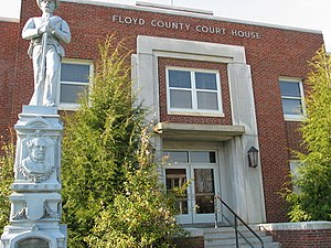
Floyd County is a county located in the U.S. state of Kentucky. As of the 2020 census, the population was 35,942. Its county seat is Prestonsburg. The county, founded in 1800, is named for Colonel John Floyd (1750–1783).

<span class="mw-page-title-main">Benton County, Arkansas</span> County in Arkansas, United States

Benton County is a county within the Northwest Arkansas region with a culture, economy, and history that have transitioned from rural and agricultural to suburban and white collar since the growth of Walmart, which is headquartered in Benton County. Created as Arkansas's 35th county on September 30, 1836, Benton County contains thirteen incorporated municipalities, including Bentonville, the county seat, and Rogers, the most populous city. The county was named after Thomas Hart Benton, a U.S. Senator from Missouri influential in Arkansas statehood.

<span class="mw-page-title-main">Carroll County, Virginia</span> County in Virginia, United States

Carroll County is a United States county located in the southwestern part of the Commonwealth of Virginia. Roughly one fifth of the county lies in the Virginia Piedmont region, while the rest is part of the Appalachian Mountains. The county seat and largest town is Hillsville.

References

  1. "Floyd County, Virginia". United States Census Bureau . Retrieved January 30, 2022.
  2. "Find a County". National Association of Counties. Archived from the original on May 31, 2011. Retrieved June 7, 2011.
  3. "A Brief History of Floyd County". Archived from the original on March 3, 2011. Retrieved February 22, 2011.
  4. McDonald, James J. (1907). Life in Old Virginia, p. 368. The Old Virginia Publishing Co. (Inc.)
  5. http://www.floydcova.org/visitors/history_floyd_county.pdf [ bare URL PDF ]
  6. Blackwell, Mary Alice & Causey, Anne Patterson (9th ed. 2005). Insider's Guide to Virginia's Blue Ridge, p. 39. The Globe Pequot Press.
  7. "Closed Circuit". Southern Poverty Law Center. Retrieved September 4, 2022.
  8. Floyd County Local History "Floyd County History and Facts". Archived from the original on October 6, 2011. Retrieved July 9, 2011.
  9. Floyd Country Store http://floydcountrystore.com
  10. County Records "About". Archived from the original on September 29, 2012. Retrieved November 10, 2012.
  11. The Crooked Road http://thecrookedroad.org/
  12. Lawless, John (August 16, 2021). "85th Annual Old Fiddlers Convention Results". Bluegrass Today. Retrieved February 22, 2022.
  13. "US Gazetteer files: 2010, 2000, and 1990". United States Census Bureau. February 12, 2011. Retrieved April 23, 2011.
  14. "About Floyd County". Visit Floyd Virginia. Retrieved February 7, 2021.
  15. "Census of Population and Housing from 1790-2000". US Census Bureau . Retrieved January 24, 2022.
  16. "Historical Census Browser". University of Virginia Library. Retrieved January 2, 2014.
  17. "Population of Counties by Decennial Census: 1900 to 1990". United States Census Bureau. Retrieved January 2, 2014.
  18. "Census 2000 PHC-T-4. Ranking Tables for Counties: 1990 and 2000" (PDF). United States Census Bureau. Archived (PDF) from the original on October 9, 2022. Retrieved January 2, 2014.
  19. 1 2 "P2 Hispanic or Latino, and Not Hispanic or Latino by Race – 2010: DEC Redistricting Data (PL 94-171) - Floyd County, Virginia". United States Census Bureau .
  20. 1 2 "P2 Hispanic or Latino, and Not Hispanic or Latino by Race – 2020: DEC Redistricting Data (PL 94-171) - Floyd County, Virginia". United States Census Bureau .
  21. "U.S. Census website". United States Census Bureau . Retrieved May 14, 2011.
  22. Dotson, Rand; '"The Grave and Scandalous Evil Infected to Your People": The Erosion of Confederate Loyalty in Floyd County, Virginia', The Virginia Magazine of History and Biography, vol. 108, No. 4 (2000), pp. 393-434
  23. Menendez, Albert J.; The Geography of Presidential Elections in the United States, 1868-2004, pp. 323, 326, 329 ISBN   0786422173
  24. Leip, David. "Dave Leip's Atlas of U.S. Presidential Elections". uselectionatlas.org. Retrieved August 19, 2018.

36°56′N80°22′W / 36.94°N 80.36°W / 36.94; -80.36