
The Bald Knob National Wildlife Refuge is a 15,022 acres (60.79 km2) (2014) wildlife refuge located in White County, Arkansas about two miles south of the town of Bald Knob. The refuge is managed by the United States Fish and Wildlife Service. The refuge features large numbers of migratory waterfowl and bald eagles during the winter months.

Big Lake National Wildlife Refuge is an 11,047-acre (45 km2) National Wildlife Refuge located in Mississippi County, Arkansas, managed by the United States Fish and Wildlife Service. It is situated 2 miles (3.2 km) east of Manila, Arkansas, and consists mostly of a shallow lake, swamp, and bottomland hardwood forests. The preservation of habitat for waterfowl in an intensely agricultural region is the primary purpose of the refuge. 6,400 acres (20 km2) of Big Lake is classified as a National Natural Landmark and 2,144 acres (8 km2) are classified as wilderness.

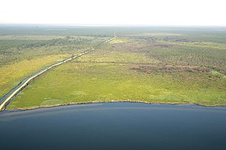
The Waccamaw River is a river, approximately 140 miles (225 km) long, in southeastern North Carolina and eastern South Carolina in the United States. It drains an area of approximately 1,110 square miles (2886 km2) in the coastal plain along the eastern border between the two states into the Atlantic Ocean. Along its upper course, it is a slow-moving, blackwater river surrounded by vast wetlands, passable only by shallow-draft watercraft such as canoe. Along its lower course, it is lined by sandy banks and old plantation houses, providing an important navigation channel with a unique geography, flowing roughly parallel to the coast.

The Shiawassee National Wildlife Refuge is a 9,870.35 acres (39.9439 km2) National Wildlife Refuge in Saginaw County managed by the United States Fish and Wildlife Service. It is located in the central portion of the lower peninsula of the U.S. state of Michigan, approximately 25 miles (40 km) south of the Saginaw Bay in Lake Huron and five miles (8 km) south of the city of Saginaw in the county's Spaulding and James townships. It was established in 1953 to provide habitat for migratory waterfowl.
The Alligator River National Wildlife Refuge is a 152,000-acre (620 km2) National Wildlife Refuge located in eastern North Carolina along the Atlantic Coast. It was established on March 14, 1984, to preserve and protect a unique wetland habitat type—the pocosin—and its associated wildlife species.
The Theodore Roosevelt National Wildlife Refuge Complex is the largest refuge complex in the state of Mississippi. Over 100,000 acres (400 km2) of refuge lands on seven refuges, including 13,000 acres (53 km2) of refuge-managed Farmers Home Administration lands, provide vital habitat for fish and wildlife in the Delta region.

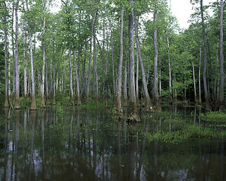
The Mingo National Wildlife Refuge is a 21,676-acre (87.7-km2) National Wildlife Refuge located in northwestern Stoddard and southeastern Wayne counties in Missouri. Its southwesternmost portion lies on the shores of Lake Wappapello. Named after the Mingo tribe, it was established to preserve bottomland hardwoods and provide waterfowl and other migratory birds in the Mississippi Flyway with nesting, feeding, brooding, and resting habitat.
The Cypress Creek National Wildlife Refuge is an American wildlife refuge. It is located in the Cache River watershed in southernmost Illinois, largely in Pulaski County, but with extensions into Union, Alexander, and Johnson counties. The refuge was established in 1990 under the authority of the Emergency Wetlands Resources Act of 1986. The refuge protects over 16,000 acres (65 km2) of the Cache River wetlands, and has a purchase boundary of 36,000 acres (146 km²) contiguous.
The Boeuf Wildlife Management Area is 51,110-acre (20,680 ha) parcel of bottomland hardwoods, cypress-tupelo swamp, and other wetland habitats in northeast Louisiana. It is owned by the Louisiana Department of Wildlife and Fisheries. Boeuf Wildlife Management Area is located in Caldwell and Catahoula Parishes, near the city of Columbia, Louisiana.
Bogue Chitto National Wildlife Refuge is located 60 mi (97 km) northeast of New Orleans, Louisiana, U.S., and encompasses 36,000 acres (150 km2) of Pearl River Basin swampland.
The Atchafalaya National Wildlife Refuge is located about 30 miles (48 km) west of Baton Rouge, Louisiana, and one mile (1.6 km) east of Krotz Springs, Louisiana, lies just east of the Atchafalaya River. In 1988 under the administration of Governor Foster the "Atchafalaya Basin Master Plan" was implemented that combined the 11,780-acre (4,770 ha) Sherburne Wildlife Management Area (WMA), the 15,220-acre (6,160 ha) Atchafalaya National Wildlife Refuge, and the 17,000-acre (6,900 ha) U.S. Army Corps of Engineers' Bayou Des Ourses into the Sherburne Complex Wildlife Management Area.
Bayou Sauvage National Wildlife Refuge is a 23,000-acre (93 km2) region of fresh and brackish marshes located within the city limits of New Orleans. It is the largest urban wildlife refuge in the United States.

Black Bayou Lake National Wildlife Refuge is one of five refuges managed in the North Louisiana Refuge Complex and one of 545 refuges in the National Wildlife Refuge System. It was established in 1997 through a unique partnership with the city of Monroe, Louisiana. The U.S. Fish and Wildlife Service has a free 99-year lease to manage the city-owned lake.
D'Arbonne National Wildlife Refuge is a National Wildlife Refuge of the United States located north of West Monroe, Louisiana. It is in Ouachita and Union Parishes on either side of Bayou D'Arbonne near its confluence with the Ouachita River. It lies on the western edge of the Mississippi River alluvial valley. It was established in 1975 to protect bottomland hardwoods and provide wintering habitat for migratory waterfowl. D'Arbonne is one of four refuges managed in the North Louisiana Refuges Complex.
Lake Ophelia National Wildlife Refuge was established in 1988 to protect the Mississippi/Red River floodplain ecosystem. The refuge is located in Avoyelles Parish, Louisiana, east central Louisiana. The refuge is named for its most prominent water body, the 350-acre (1.4 km2) Lake Ophelia that was at one time a channel of the nearby Red River of the South.
Upper Ouachita National Wildlife Refuge was established in 1978 and is located in Union and Morehouse Parishes in northern Louisiana.
Bond Swamp National Wildlife Refuge, located 6 miles south of Macon, Georgia, United States, was established in 1989 to protect, maintain and enhance the forested wetland ecosystem of the Ocmulgee River floodplain. It opened to the public in 2000 and consists of 8,600 acres situated along the fall line separating the Piedmont and Coastal Plains. The acquisition boundary established in 1999 includes around 17,000 acres, though the Fish and Wildlife service has been unable to acquire much private land. The refuge has a diversity of vegetation communities, including mixed hardwood-pine, bottomland hardwoods, tupelo gum swamp forests, creeks, tributaries, beaver swamps and oxbow lakes. The refuge is rich in wildlife diversity including white-tailed deer, wood ducks, black bears, alligators, wild turkey, a nesting pair of bald eagles and excellent wintering habitat for waterfowl. Extensive bottomland hardwoods provide critical habitat for neotropical songbirds of concern, such as Swainson's warbler, wood thrush, prothonotary warbler and yellow-billed cuckoo. The combination of warm weather and wet areas at Bond Swamp provide ideal conditions for a variety of reptile and amphibian species.

Situated along the Pee Dee River, Pee Dee National Wildlife Refuge contains 8,443 acres (34.17 km2) in Anson and Richmond Counties, North Carolina. The refuge was established to provide wintering habitat for migratory waterfowl. The refuge was established in October 1963 to provide habitat for geese and other waterfowl.

The Middle Atlantic coastal forests are a temperate coniferous forest mixed with patches of evergreen broadleaved forests along the coast of the southeastern United States.
The Mississippi Alluvial Plain is a Level III ecoregion designated by the Environmental Protection Agency (EPA) in seven U.S. states, though predominantly in Arkansas, Louisiana, and Mississippi. It parallels the Mississippi River from the Midwestern United States to the Gulf of Mexico.


