List of counties in Idaho

Last updated

Counties of Idaho
Location State of Idaho
Number44
Populations801 (Clark) – 524,673 (Ada)
Areas408 square miles (1,060 km2) (Payette) – 8,485 square miles (21,980 km2) (Idaho)
Government
Subdivisions

There are 44 counties in the U.S. state of Idaho.

The Idaho Territory was organized in March 1863, and Owyhee County was the first county in the territory to be organized, in December of that year. Oneida County was organized in January 1864, while Missoula County was adopted the same month, before becoming part of the new Montana Territory in May. Shoshone, Nez Perce, Idaho and Boise Counties were recognized in February 1864; Alturas County was organized the same month. In December 1864, Kootenai and Ada Counties were created; Lah-Toh County was also created at this time but was abolished in 1867.

Contents

Idaho's present-day boundaries were established in 1868, and Lemhi County was created the following year. By the time Idaho was admitted to the Union as the 43rd state in 1890, a further eight counties had been created, bringing the total to 18. After Canyon, Fremont and Bannock Counties had been created, Alturas and Logan Counties were merged to form Blaine County in March 1895; Lincoln County was formed out of Blaine County later the same month. Bonner and Twin Falls Counties were created in 1907, before a further 21 counties were created between 1911 and 1919, bringing the total to the present-day 44.

Since 1945, each county has used a code on its license plates that features the first letter of the county's name. Where the names of two or more counties start with the same letter, in each of these counties the letter is preceded by a number indicating that county's order in the alphabetical list. For instance, the four counties beginning with 'L' in alphabetical order are Latah, Lemhi, Lewis and Lincoln; the codes for these counties are thus 1L, 2L, 3L and 4L respectively. Elmore, Idaho, Kootenai, Nez Perce, Shoshone, Valley, and Washington Counties are the only ones in the state with their respective first letters; in these counties, the letter alone serves as the code.

Alphabetical list

County
FIPS code [1] County seat [2] Est. [2] Origin [3] License plate prefix [4] Etymology
[5]
Population [6] Area [2] Map
AdaCounty 001 Boise 1864Boise County1AAda Riggs (1856-1909), daughter of H. C. Riggs, a member of the Idaho Territorial Legislature.524,6731,055 sq mi
(2,732 km2)
Map of Idaho highlighting Ada County.svg
AdamsCounty 003 Council 1911Washington County2A John Adams (1735–1826), second President of the United States (1797–1801).4,9031,365 sq mi
(3,535 km2)
Map of Idaho highlighting Adams County.svg
BannockCounty 005 Pocatello 1893Bingham County1B Bannock Native American tribe.90,4001,113 sq mi
(2,883 km2)
Map of Idaho highlighting Bannock County.svg
Bear LakeCounty 007 Paris 1875Oneida County2B Bear Lake on the Utah/Idaho border.6,766971 sq mi
(2,515 km2)
Map of Idaho highlighting Bear Lake County.svg
BenewahCounty 009 St. Maries 1915Kootenai County3BBen'wah, chief of the Coeur d'Alene Tribe 10,369776 sq mi
(2,010 km2)
Map of Idaho highlighting Benewah County.svg
BinghamCounty 011 Blackfoot 1885Oneida County4B Henry H. Bingham (1841-1912), a general in the American Civil War and a U.S. Congressman from Pennsylvania.50,3952,095 sq mi
(5,426 km2)
Map of Idaho highlighting Bingham County.svg
BlaineCounty 013 Hailey 1895 Alturas and Logan Counties5B James G. Blaine (1830-1893), United States Secretary of State (1881, 1889-1892).25,0412,645 sq mi
(6,851 km2)
Map of Idaho highlighting Blaine County.svg
BoiseCounty 015 Idaho City 1864original county6B Boise River 8,5171,902 sq mi
(4,926 km2)
Map of Idaho highlighting Boise County.svg
BonnerCounty 017 Sandpoint 1907Kootenai County7BEdwin L. Bonner (1834-1902), originator of an 1864 ferry service on the Kootenai River.52,5471,738 sq mi
(4,501 km2)
Map of Idaho highlighting Bonner County.svg
BonnevilleCounty 019 Idaho Falls 1911Bingham County8B Benjamin Bonneville (1796-1878), a French-born explorer of the West.131,3661,869 sq mi
(4,841 km2)
Map of Idaho highlighting Bonneville County.svg
BoundaryCounty 021 Bonners Ferry 1915Bonner County9BBorders Canada on the north.13,5571,269 sq mi
(3,287 km2)
Map of Idaho highlighting Boundary County.svg
ButteCounty 023 Arco 1917Bingham, Blaine, and Jefferson Counties10B Buttes rising from the Snake River Plain.2,7582,233 sq mi
(5,783 km2)
Map of Idaho highlighting Butte County.svg
CamasCounty 025 Fairfield 1917Blaine County1C Camassia, a plant species important as a food source among Native Americans and early settlers.1,2321,077 sq mi
(2,789 km2)
Map of Idaho highlighting Camas County.svg
CanyonCounty 027 Caldwell 1892Ada County2CDisputed, either a canyon of the Boise River near Caldwell or a canyon of the Snake River which forms part of the county's boundary.257,674590 sq mi
(1,528 km2)
Map of Idaho highlighting Canyon County.svg
CaribouCounty 029 Soda Springs 1919Bannock County3C Caribou Mountains 7,2191,766 sq mi
(4,574 km2)
Map of Idaho highlighting Caribou County.svg
CassiaCounty 031 Burley 1879Owyhee County4CDisputed, either Cassia Creek or a member of the Mormon Battalion, James John Cazier (1821-1890).25,6962,567 sq mi
(6,648 km2)
Map of Idaho highlighting Cassia County.svg
ClarkCounty 033 Dubois 1919Fremont County5CSam K. Clark (1857-1933), early settler and a member of the Idaho Senate.8011,765 sq mi
(4,571 km2)
Map of Idaho highlighting Clark County.svg
ClearwaterCounty 035 Orofino 1911Nez Perce County6C Clearwater River 9,2142,462 sq mi
(6,377 km2)
Map of Idaho highlighting Clearwater County.svg
CusterCounty 037 Challis 1881Alturas and Lemhi Counties7CGeneral Custer mine, named after George Armstrong Custer (1839-1876), United States Army general.4,5234,926 sq mi
(12,758 km2)
Map of Idaho highlighting Custer County.svg
ElmoreCounty 039 Mountain Home 1889 Alturas County EIda Elmore mines, locally noted for gold and silver production in the 1860s.29,7243,078 sq mi
(7,972 km2)
Map of Idaho highlighting Elmore County.svg
FranklinCounty 041 Preston 1913Oneida County1F Franklin D. Richards (1821-1899), early LDS Church apostle.15,494666 sq mi
(1,725 km2)
Map of Idaho highlighting Franklin County.svg
FremontCounty 043 Saint Anthony 1893Bingham County2F John C. Frémont (1813-1890), an explorer of the West.14,1961,867 sq mi
(4,836 km2)
Map of Idaho highlighting Fremont County.svg
GemCounty 045 Emmett 1915Boise and Canyon Counties1G State nickname of "Gem State."21,071563 sq mi
(1,458 km2)
Map of Idaho highlighting Gem County.svg
GoodingCounty 047 Gooding 1913Lincoln County2G Frank R. Gooding (1859-1928), seventh Governor of Idaho (1905-1909), U.S. Senator (1921-1928).16,061731 sq mi
(1,893 km2)
Map of Idaho highlighting Gooding County.svg
IdahoCounty 049 Grangeville 1864original countyI Columbia River steamship Idaho launched in 1860. Name predates both Idaho Territory and the State of Idaho.17,8908,485 sq mi
(21,976 km2)
Map of Idaho highlighting Idaho County.svg
JeffersonCounty 051 Rigby 1913Fremont County1J Thomas Jefferson (1743-1826), third President of the United States (1801-1809).34,1981,095 sq mi
(2,836 km2)
Map of Idaho highlighting Jefferson County.svg
JeromeCounty 053 Jerome 1919Gooding and Lincoln Counties2JDisputed, either North Side Irrigation Project developer Jerome Hill, his son-in-law Jerome Kuhn (1898-1952), or his grandson Jerome Kuhn, Jr.25,479600 sq mi
(1,554 km2)
Map of Idaho highlighting Jerome County.svg
KootenaiCounty 055 Coeur d'Alene 1864Nez Perce CountyK Kootenai Native American tribe.185,0101,245 sq mi
(3,225 km2)
Map of Idaho highlighting Kootenai County.svg
LatahCounty 057 Moscow 1888Nez Perce County1LLatah Creek, Nez Perce for "the place of pine trees and sestle."41,3011,077 sq mi
(2,789 km2)
Map of Idaho highlighting Latah County.svg
LemhiCounty 059 Salmon 1869Idaho County2L Limhi, king of the Nephites according to the Book of Mormon.8,4414,564 sq mi
(11,821 km2)
Map of Idaho highlighting Lemhi County.svg
LewisCounty 061 Nezperce 1911Nez Perce County3L Meriwether Lewis (1774-1809), a leader of the Lewis and Clark Expedition.3,739479 sq mi
(1,241 km2)
Map of Idaho highlighting Lewis County.svg
LincolnCounty 063 Shoshone 1895Blaine County4L Abraham Lincoln (1809-1865), sixteenth President of the United States (1861-1865). Idaho Territory was founded under Lincoln's administration.5,4501,206 sq mi
(3,124 km2)
Map of Idaho highlighting Lincoln County.svg
MadisonCounty 065 Rexburg 1913Fremont County1M James Madison (1751-1836), fourth President of the United States (1809-1817).54,547472 sq mi
(1,222 km2)
Map of Idaho highlighting Madison County.svg
MinidokaCounty 067 Rupert 1913Lincoln County2MDisputed Native American origin, either Lakota for "a fountain or spring of water" or Shoshoni for "broad expanse."22,480760 sq mi
(1,968 km2)
Map of Idaho highlighting Minidoka County.svg
Nez PerceCounty 069 Lewiston 1864original countyNThe Nez Perce, a Native American tribe.42,987849 sq mi
(2,199 km2)
Map of Idaho highlighting Nez Perce County.svg
OneidaCounty 071 Malad City 1864original county1O Oneida Lake in New York state, where many early settlers were from.4,9531,200 sq mi
(3,108 km2)
Map of Idaho highlighting Oneida County.svg
OwyheeCounty 073 Murphy 1863original county2OAlternate spelling of Hawaii. Hawaiian fur trappers explored the area in 1819 and 1820.12,7227,678 sq mi
(19,886 km2)
Map of Idaho highlighting Owyhee County.svg
PayetteCounty 075 Payette 1917Canyon County1P Francois Payette (1793-1844?), Canadian-born fur trader and early settler.27,279408 sq mi
(1,057 km2)
Map of Idaho highlighting Payette County.svg
PowerCounty 077 American Falls 1913Bingham, Blaine, and Oneida Counties2PThe American Falls Power Plant 8,2531,406 sq mi
(3,642 km2)
Map of Idaho highlighting Power County.svg
ShoshoneCounty 079 Wallace 1864original countyS Shoshone Native American tribe.14,0262,634 sq mi
(6,822 km2)
Map of Idaho highlighting Shoshone County.svg
TetonCounty 081 Driggs 1915Bingham, Fremont, and Madison Counties1T Teton Range in Wyoming.12,549450 sq mi
(1,165 km2)
Map of Idaho highlighting Teton County.svg
Twin FallsCounty 083 Twin Falls 1907Cassia County2TTwin Falls waterfall on the Snake River.95,1561,925 sq mi
(4,986 km2)
Map of Idaho highlighting Twin Falls County.svg
ValleyCounty 085 Cascade 1917Boise and Idaho CountiesVLong Valley located in the county.12,6443,733 sq mi
(9,668 km2)
Map of Idaho highlighting Valley County.svg
WashingtonCounty 087 Weiser 1879Ada CountyW George Washington (1732-1799), first President of the United States (1789-1797).11,4251,456 sq mi
(3,771 km2)
Map of Idaho highlighting Washington County.svg

Extinct counties

Related Research Articles

<span class="mw-page-title-main">Nez Perce</span> Indigenous peoples of North America

The Nez Perce are an Indigenous people of the Plateau who still live on a fraction of the lands on the southeastern Columbia River Plateau in the Pacific Northwest. This region has been occupied for at least 11,500 years.

<span class="mw-page-title-main">Nez Perce County, Idaho</span> County in Idaho, United States

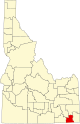
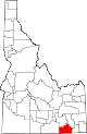
Nez Perce County is a county located in the U.S. state of Idaho. As of the 2020 census, the population was 42,090. The county seat is Lewiston. The county is named after the Native American Nez Perce tribe. Nez Perce County is part of the Lewiston, Idaho–WA Metropolitan Statistical Area.

<span class="mw-page-title-main">Shoshone County, Idaho</span> County in Idaho, United States

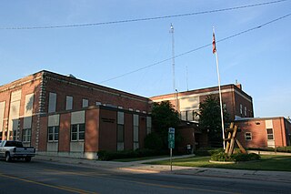
Shoshone County is a county in the U.S. state of Idaho. As of the 2020 census, the population was 13,169. The county seat is Wallace and the largest city is Kellogg. The county was established in 1864, named for the Native American Shoshone tribe.

<span class="mw-page-title-main">Latah County, Idaho</span> County in Idaho, United States

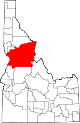
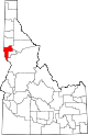
Latah County is a county located in the north central region of the U.S. state of Idaho. As of the 2020 census, the population was 39,517. The county seat and largest city is Moscow, the home of the University of Idaho, the state's flagship university.

<span class="mw-page-title-main">Kootenai County, Idaho</span> County in Idaho, United States

Kootenai County is located in the U.S. state of Idaho. As of the 2020 census, its population was 171,362, making it the third-most populous county in Idaho and by far the largest in North Idaho, the county accounting for 45.4% of the region's total population. The county seat and largest city is Coeur d'Alene. The county was established in 1864 and named after the Kootenai tribe.

<span class="mw-page-title-main">Idaho County, Idaho</span> County in Idaho, United States

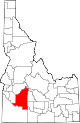
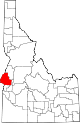
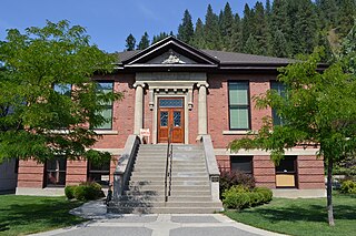
Idaho County is a county in the U.S. state of Idaho, and the largest by area in the state. As of the 2020 census, the population was 16,541. The county seat is Grangeville. Previous county seats of the area were Florence (1864–68), Washington (1868–75), and Mount Idaho (1875–1902).

<span class="mw-page-title-main">Bonner County, Idaho</span> County in Idaho, United States

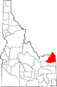
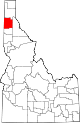
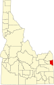
Bonner County is a county in the northern part of the U.S. state of Idaho. As of the 2020 census, the population was 47,110. The county seat and largest city is Sandpoint. Partitioned from Kootenai County and established in 1907, it was named for Edwin L. Bonner, a ferry operator.

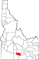
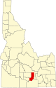
Alturas County was a county in Idaho Territory and later the state of Idaho from 1864 to 1895. It covered an area larger than the states of Maryland, New Jersey, and Delaware combined. Most present-day southern Idaho counties were created at least in part from the original Alturas County area. The name Alturas comes from a Spanish word for "mountain summits" or "mountainous heights."

Logan County was a county in Idaho Territory and later the state of Idaho from 1889 to 1895.

Lah-Toh County was a county in Idaho Territory from 1864 to 1867.

<span class="mw-page-title-main">Lincoln (proposed Northwestern state)</span> Proposed U.S. northwestern state

Lincoln is the name for several proposals to create a new state in the Northwest United States. The proposed State has been defined in multiple ways, but can generally be said to be coterminous with the region known as the Inland Northwest. The proposed state was named in honor of Abraham Lincoln, who was president during the American Civil War. His name had also been proposed for the states that were eventually named North Dakota and Wyoming.

<span class="mw-page-title-main">Idaho Transportation Department</span> State transportation department in Idaho, United States

The Idaho Transportation Department (ITD) is the state of Idaho governmental organization responsible for state transportation infrastructure. This includes ongoing operations and maintenance as well as planning for future needs of the state and its citizens. The agency is responsible for overseeing the disbursement of federal, state, and grant funding for transportation programs in the state.

<span class="mw-page-title-main">1964 United States presidential election in Idaho</span> Election in Idaho

The 1964 United States presidential election in Idaho took place on November 3, 1964, as part of the 1964 United States presidential election, which was held throughout all 50 states and Washington, D.C. Voters chose four representatives, or electors to the Electoral College, who voted for president and vice president.

<span class="mw-page-title-main">Idaho Territory in the American Civil War</span>

The history of Idaho in the American Civil War is atypical, as the territory was far from the battlefields.

Fort Lemhi was a mission approximately two miles (3 km) north of present-day Tendoy, Idaho, occupied by Mormon missionaries from 1855 to 1858.

<span class="mw-page-title-main">Lemhi Reservation</span>

The Lemhi Reservation was a United States Indian Reservation for the Lemhi Shoshone from 1875 to 1907. During almost all this time their main chief was Tendoy.

<span class="mw-page-title-main">Bibliography of Idaho history</span>

The following works deal with the cultural, political, economic, military, biographical and geologic history of pre-territorial Idaho, Idaho Territory and the State of Idaho.

<span class="mw-page-title-main">1976 United States presidential election in Idaho</span> Election in Idaho

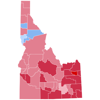
The 1976 United States presidential election in Idaho took place on November 2, 1976, as part of the 1976 United States presidential election. State voters chose four representatives, or electors, to the Electoral College, who voted for president and vice president.

References

  1. "EPA County FIPS Code Listing". EPA.gov. Retrieved February 23, 2008.
  2. 1 2 3 National Association of Counties. "NACo - Find a county". Archived from the original on October 24, 2007. Retrieved April 26, 2008.
  3. Hailey, John (1910). The History of Idaho. Press of Syms-York company. pp.  305–307. OCLC   5793481 . Retrieved April 26, 2008.
  4. "County License Plate Designators List" (PDF). Idaho Transportation Department. Retrieved June 30, 2018.
  5. "List of Idaho Counties - Idaho.gov". State of Idaho. Archived from the original on July 5, 2008. Retrieved July 30, 2008.
  6. "Idaho QuickFacts". U.S. Census Bureau. Retrieved April 20, 2024. (2023 Census estimate)