Oakland, Maryland

Last updated

Oakland, Maryland
2ndStreet OaklandMD 2589.jpg
Second Street in Oakland, part of the Oakland Historic District
Flag of Oakland, Maryland.png
Seal of Oakland, Maryland.svg
Garrett County Maryland Incorporated and Unincorporated areas Oakland Highlighted.svg
Location of Oakland, Maryland
Coordinates: 39°25′00″N79°24′08″W / 39.41667°N 79.40222°W / 39.41667; -79.40222
Country Flag of the United States.svg United States
State Flag of Maryland.svg  Maryland
County Flag of Garrett County, Maryland.svg Garrett
Incorporated 1862 [1]
Government
  Type Mayor-council government
Area
[2]
  Total2.72 sq mi (7.05 km2)
  Land2.71 sq mi (7.02 km2)
  Water0.01 sq mi (0.02 km2)
Elevation
[3]
2,451 ft (747 m)
Population
 (2020)
  Total1,851
  Density682.52/sq mi (263.53/km2)
Time zone UTC−5 (Eastern (EST))
  Summer (DST) UTC−4 (EDT)
ZIP code
21550
Area code(s) 301, 240
FIPS code 24-57650
GNIS feature ID2391338 [3]
Website www.OaklandMD.com

Oakland is a town in and the county seat of Garrett County, Maryland, United States. The population was 1,851 at the 2020 census. It is situated only miles from the source of the Potomac River, which flows directly into Chesapeake Bay. It is also near the Wisp Resort at Deep Creek Lake. Oakland is part of the Pittsburgh media market.

Contents

History

Oakland in 1910, with the Baltimore and Ohio Railroad passing through town Maryland. Oakland, railroad crossing in mid-town LCCN2012649461.jpg
Oakland in 1910, with the Baltimore and Ohio Railroad passing through town

Oakland was formally incorporated as a town in 1862.

The town is home to a historic B&O railroad station, which was listed on the National Register of Historic Places in 1973, and restored in the 2000s. [4] Trains still run on the rail tracks behind the station, but it is mainly used for special organizations or gatherings at present. A gift shop is located within the station. In front of the station, there are a plethora of festivities that go on, mainly seasonal activities such as housing the town Christmas tree, decorating the plaza for a holiday, and sometimes parties.

Main Street of Oakland consists mainly of historic two to four story edifices that house the main shopping facilities in the area, such as a theatre, museum, book store, a local pharmacy, antique shops, clothing stores and banks. Many of the homes and businesses in the downtown area are examples of Victorian architecture. Much of the central section of Oakland is part of the Oakland Historic District, listed on the National Register of Historic Places in 1984. [4] Also listed on the National Register are the Garrett County Courthouse and Hoye Site. [4]

Oakland Hotel, circa 1909 Oakland Maryland Hotel from Book of the Royal Blue April 1909 Vol 12 No 07 Page 10.jpg
Oakland Hotel, circa 1909

In the late 19th century and early 20th century, a large hotel named the Oakland Hotel was located near the downtown railroad station. It was constructed in 1878 by the B&O Railroad. [5] The hotel was a major tourist attraction for that time period until it was torn down in the early 20th century.

One of the most prominent and historic churches in Oakland is St. Matthew's Episcopal Church, where U.S. Presidents Ulysses S. Grant, James Garfield, Grover Cleveland, and Benjamin Harrison have all attended services. Because of this, it is now called the "Church of Presidents." Another prominent and historic church is St. Peter the Apostle Church, [6] a Catholic church located on Fourth Street. A large neoclassical courthouse is also very prominent and dominates the town center.

Geography

Oakland is in the south-central to western portion of Garrett County. It is set in a small valley. According to the United States Census Bureau, the town has a total area of 2.60 square miles (6.73 km2), of which 2.59 square miles (6.71 km2) is land and 0.01 square miles (0.03 km2) is water. [7] It is only 6.61 miles from Second Street to Deep Creek Lake.

Climate

Oakland, owing to its high elevation and valley location, is among the coldest and snowiest locales in the state of Maryland, and has a warm-summer humid continental climate (Köppen Dfb). The state record low of −40 °F or −40 °C was recorded here on January 13, 1912. The monthly mean temperature ranges from 25.1 °F (−3.8 °C) in January to 68.4 °F (20.2 °C) in July, with temperatures not reaching above freezing on an average 34 afternoons and falling to 0 °F (−17.8 °C) or below on an average of 5.8 mornings. The average first and last dates for freezing temperatures are September 28 and May 15, respectively.

The record high is 101 °F (38.3 °C) on August 7, 1918, which, together with the preceding day, are the only two instances of 100 °F (37.8 °C)+ readings on record in Oakland; from 1981 to 2010, only thirteen years ever reached 90 °F (32.2 °C).

According to weather data tallied between July 1, 1985, and June 30, 2015, for every location in the National Oceanic and Atmospheric Administration's official climate database, Oakland is the snowiest place in the state of Maryland with an average of 106.1 inches or 2.69 metres of snow per year. [8] The most snow in 24 hours was 40.0 inches (1.02 m) on February 16, 1908, and the average first and last dates for measurable (≥0.1 inches or 0.0025 metres) snowfall are November 13 and April 7.

Climate data for Oakland, Maryland (1991−2020 normals, extremes 1893−present)
MonthJanFebMarAprMayJunJulAugSepOctNovDecYear
Record high °F (°C)75
(24)
76
(24)
83
(28)
88
(31)
89
(32)
95
(35)
98
(37)
101
(38)
95
(35)
88
(31)
78
(26)
74
(23)
101
(38)
Mean maximum °F (°C)61.0
(16.1)
61.9
(16.6)
70.5
(21.4)
79.4
(26.3)
83.7
(28.7)
86.1
(30.1)
88.3
(31.3)
86.7
(30.4)
84.5
(29.2)
78.1
(25.6)
71.2
(21.8)
62.7
(17.1)
88.8
(31.6)
Mean daily maximum °F (°C)36.7
(2.6)
40.3
(4.6)
48.9
(9.4)
61.3
(16.3)
70.0
(21.1)
77.0
(25.0)
81.0
(27.2)
79.6
(26.4)
73.8
(23.2)
63.4
(17.4)
51.5
(10.8)
41.5
(5.3)
60.4
(15.8)
Daily mean °F (°C)27.5
(−2.5)
30.0
(−1.1)
37.8
(3.2)
49.0
(9.4)
58.9
(14.9)
66.5
(19.2)
70.7
(21.5)
69.0
(20.6)
62.4
(16.9)
51.4
(10.8)
40.6
(4.8)
32.7
(0.4)
49.7
(9.8)
Mean daily minimum °F (°C)18.3
(−7.6)
19.8
(−6.8)
26.6
(−3.0)
36.7
(2.6)
47.7
(8.7)
56.1
(13.4)
60.4
(15.8)
58.3
(14.6)
51.0
(10.6)
39.5
(4.2)
29.7
(−1.3)
23.8
(−4.6)
39.0
(3.9)
Mean minimum °F (°C)−6.5
(−21.4)
−3.1
(−19.5)
5.8
(−14.6)
20.7
(−6.3)
30.0
(−1.1)
39.6
(4.2)
46.4
(8.0)
45.2
(7.3)
35.0
(1.7)
24.0
(−4.4)
12.6
(−10.8)
3.7
(−15.7)
−9.4
(−23.0)
Record low °F (°C)−40
(−40)
−29
(−34)
−20
(−29)
−2
(−19)
17
(−8)
26
(−3)
33
(1)
30
(−1)
19
(−7)
7
(−14)
−16
(−27)
−32
(−36)
−40
(−40)
Average precipitation inches (mm)3.90
(99)
3.56
(90)
4.32
(110)
4.33
(110)
5.34
(136)
4.91
(125)
5.14
(131)
4.33
(110)
3.69
(94)
3.61
(92)
3.38
(86)
4.29
(109)
50.80
(1,290)
Average snowfall inches (cm)30.2
(77)
22.0
(56)
19.6
(50)
3.7
(9.4)
0.0
(0.0)
0.0
(0.0)
0.0
(0.0)
0.0
(0.0)
0.0
(0.0)
1.6
(4.1)
6.4
(16)
21.4
(54)
104.9
(266)
Average extreme snow depth inches (cm)13.2
(34)
9.4
(24)
5.0
(13)
1.0
(2.5)
0.0
(0.0)
0.0
(0.0)
0.0
(0.0)
0.0
(0.0)
0.0
(0.0)
1.0
(2.5)
1.9
(4.8)
8.3
(21)
17.8
(45)
Average precipitation days (≥ 0.01 in)17.414.114.815.116.114.713.412.311.712.712.416.0170.7
Average snowy days (≥ 0.1 in)11.38.36.41.90.00.00.00.00.00.52.97.839.1
Source: NOAA [9] [10]

Demographics

Historical population
CensusPop.Note
1880 910
1890 1,04614.9%
1900 1,17011.9%
1910 1,36616.8%
1920 1,225−10.3%
1930 1,58329.2%
1940 1,5870.3%
1950 1,6403.3%
1960 1,97720.5%
1970 1,786−9.7%
1980 1,99411.6%
1990 1,741−12.7%
2000 1,93010.9%
2010 1,925−0.3%
2020 1,851−3.8%
U.S. Decennial Census [11]

2010 census

As of the census [12] of 2010, there were 1,925 persons, 875 households, and 470 families living in the town. The population density was 743.2 inhabitants per square mile (287.0/km2). There were 1,009 housing units at an average density of 389.6 per square mile (150.4/km2). The racial makeup of the town was 98.0% White, 0.2% African American, 0.3% Native American, 0.6% Asian, 0.1% from other races, and 0.9% from two or more races. Hispanic or Latino of any race were 0.7% of the population.

There were 875 households, of which 23.1% had children under the age of 18 living with them, 40.1% were married couples living together, 10.5% had a female householder with no husband present, 3.1% had a male householder with no wife present, and 46.3% were non-families. 40.5% of all households were made up of individuals, and 16.6% had someone living alone who was 65 years of age or older. The average household size was 2.03 and the average family size was 2.73. and 24; 22.6% were from 25 to 44; 30.2% were from 45 to 64; and 22.5% were 65 years of age or older. The gender makeup of the town was 47.7% male and 52.3% female.

2000 census

As of the census [13] of 2000, there were 1,930 persons, 787 households, and 447 families living in the town. The population density was 915.7 inhabitants per square mile (353.6/km2). There were 918 housing units at an average density of 435.5 per square mile (168.1/km2). The racial makeup of the town was 98.13% White, 0.73% African American, 0.16% Native American, 0.57% Asian, 0.16% from other races, and 0.26% from two or more races. Hispanic or Latino of any race were 0.78% of the population. 33% of Oakland's residents were of German descent, 11% English, 11% Irish, 6% Italian, 2% Dutch, 2% French, 2% Polish, 2% Scottish, 2% Scotch-Irish and 2% Swedish. People of Swiss, British, Welsh and Hungarian descent each comprised 1% of the population. [14]

There were 787 households, out of which 25.3% had children under the age of 18 living with them, 43.6% were married couples living together, 9.8% had a female householder with no husband present, and 43.1% were non-families. 38.8% of all households were made up of individuals, and 18.7% had someone living alone who was 65 years of age or older. The average household size was 2.09 and the average family size was 2.75.

In the town, the population was spread out, with 18.5% under the age of 18, 9.4% from 18 to 24, 24.0% from 25 to 44, 23.2% from 45 to 64, and 24.9% who were 65 years of age or older. The median age was 43 years. For every 100 females, there were 85.8 males. For every 100 females age 18 and over, there were 84.2 males.

The median income for a household in the town was $26,728, and the median income for a family was $38,750. Males had a median income of $29,625 versus $21,542 for females. The per capita income for the town was $16,872. About 13.3% of families and 19.0% of the population were below the poverty line, including 21.9% of those under age 18 and 21.0% of those age 65 or over.

The Oakland area is home to an Amish community that consists of a church district of about 70 homes. The Amish community dates back to 1850 and became associated with the New Order Amish, with electricity permitted inside of homes. [15] The Amish community in Oakland has a small number of converts to the Amish faith, a rarity in the Amish world. There are only between 150 and 200 Amish converts in the United States out of a population around 200,000. The Lancaster County, Pennsylvania Amish have had only one successful convert in over 100 years. [16]

Attractions and events

Post office in Oakland Oakland Post Office (21416756858).jpg
Post office in Oakland

The Oakland post office is home to a Depression-era mural, Buckwheat Harvest, painted by American artist Robert Franklin Gates. Gates was funded by the Treasury Section of Fine Arts to complete the mural as part of President Franklin Roosevelt's New Deal. Gates was probably inspired by Garrett County's strong tradition of growing buckwheat. [17]

Oakland is home to the Oakland B&O Museum [18] and the Garrett County Museum of Transportation. [19]

Transportation

Oakland station, formerly along the Baltimore and Ohio Railroad RailroadStationOakland2012.jpg
Oakland station, formerly along the Baltimore and Ohio Railroad

Several state-maintained highways serve Oakland. The most prominent of these is U.S. Route 219, which follows Garrett Highway, Oak Street and Third Street through the town. To the north, US 219 connects to Maryland Route 42, Interstate 68 and U.S. Route 40, along with the towns of Accident and Grantsville, before passing into Pennsylvania. Heading south, US 219 briefly passes through Mountain Lake Park and connects with U.S. Route 50 before entering West Virginia. Two other state highways, Maryland Route 39 and Maryland Route 135 also serve Oakland. MD 39 heads northwest to West Virginia, while MD 135 heads east, connecting to Maryland Route 560, Maryland Route 38 and Maryland Route 495, as well as the towns of Mountain Lake Park and Deer Park, before entering Allegany County near the town of Luke.

Notable people

Related Research Articles

<span class="mw-page-title-main">Garrett County, Maryland</span> County in Maryland, United States

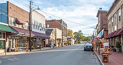
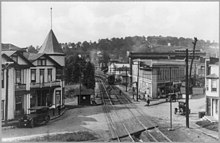
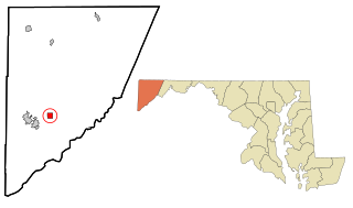
Garrett County is the westernmost county of the U.S. state of Maryland completely within the Appalachian Mountains. As of the 2020 census, the population was 28,806, making it the third-least populous county in Maryland. Its county seat is Oakland. The county was named for John Work Garrett (1820–1884), president of the Baltimore and Ohio Railroad. Created from Allegany County in 1872, it was the last county to be formed in the state.

<span class="mw-page-title-main">Garrett Park, Maryland</span> Town in Maryland, United States

Garrett Park is a town in Montgomery County, Maryland, United States. It was named after a former president of the Baltimore and Ohio Railroad, Robert W. Garrett. The population was 996 at the 2020 census. Garrett Park is home to Garrett Park Elementary School, located just outside the town proper.

<span class="mw-page-title-main">Midland, Maryland</span> Town in Maryland, United States

Midland is a town in Allegany County, Maryland, United States, along the Georges Creek Valley. It is part of the Cumberland, MD-WV Metropolitan Statistical Area. The population was 446 at the 2010 census. Midland was founded in 1850 as a coal-mining community, though today only some strip mining remains.

<span class="mw-page-title-main">Westernport, Maryland</span> Town in Maryland, United States

Westernport is a town in Allegany County, Maryland, United States, along the Georges Creek Valley. It is part of the Cumberland, MD-WV Metropolitan Statistical Area. The population was 1,888 at the 2010 census.

<span class="mw-page-title-main">New Windsor, Maryland</span> Town in Maryland, United States

New Windsor is a town in Carroll County, Maryland, United States. The population was 1,398 at the 2020 census. It is located 6 miles (10 km) west of Westminster on Maryland Route 31.

<span class="mw-page-title-main">Cecilton, Maryland</span> Town in Maryland, United States

Cecilton is a town in Cecil County, Maryland, United States. The population was 663 at the 2010 census.

<span class="mw-page-title-main">Chesapeake City, Maryland</span> Town in Maryland, United States

Chesapeake City is a town in Cecil County, Maryland, United States. The population was 736 at the 2020 census.

<span class="mw-page-title-main">North East, Maryland</span> Town in Maryland, United States

North East is a town in Cecil County, Maryland, United States. It is located between Philadelphia and Baltimore. The population was 3,572 at the 2010 census.

<span class="mw-page-title-main">Rising Sun, Maryland</span> Town in Maryland, United States

Rising Sun is a town in Cecil County, Maryland, United States. The population was 2,781 at the 2010 census.

<span class="mw-page-title-main">Deer Park, Maryland</span> Town in Maryland, United States

Deer Park is a town in Garrett County, Maryland, United States. The population was 399 at the 2010 census. It is part of the Pittsburgh Media Market.

<span class="mw-page-title-main">Friendsville, Maryland</span> Town in Maryland, United States

Friendsville is a town in Garrett County, Maryland, United States. The population was 438 at the 2020 census.

<span class="mw-page-title-main">Grantsville, Maryland</span> Town in Maryland, United States

Grantsville is a town in the northern part of Garrett County, Maryland, United States, near the Pennsylvania border. The population was 968 as of the 2020 census.

<span class="mw-page-title-main">Kitzmiller, Maryland</span> Town in Maryland, United States

Kitzmiller is a town in Garrett County, Maryland, United States. The population was 321 at the 2010 census.

<span class="mw-page-title-main">Mountain Lake Park, Maryland</span> Town in Maryland, United States

Mountain Lake Park is a town in Garrett County, Maryland, United States. The population was 2,147 as of the 2020 census.

<span class="mw-page-title-main">Bel Air, Harford County, Maryland</span> Town in Maryland

The town of Bel Air is the county seat of Harford County, Maryland. According to the 2020 United States census, the population of the town was 10,661.

<span class="mw-page-title-main">Chevy Chase View, Maryland</span> Town in Maryland, United States

Chevy Chase View is a town in Montgomery County, Maryland, United States. Established as a Special Tax District in 1924, the town was formally incorporated on October 28, 1993. The population was 1,005 at the 2020 census.

<span class="mw-page-title-main">Laytonsville, Maryland</span> Town in Maryland, United States

Laytonsville is a town in Montgomery County, Maryland, United States. The population was 572 at the 2020 census, up from 353 in 2010. Laytonsville was incorporated in 1892.

<span class="mw-page-title-main">Boonsboro, Maryland</span> Town in Maryland, United States

Boonsboro is a town in Washington County, Maryland, United States, located at the foot of South Mountain. It nearly borders Frederick County and is proximate to the Antietam National Battlefield. The population was 3,779 at the 2020 census.

<span class="mw-page-title-main">Clear Spring, Maryland</span> Town in Maryland, United States

Clear Spring is a town in Washington County, Maryland, United States. The population was 358 at the 2010 census.

<span class="mw-page-title-main">Hampstead, Maryland</span> Town in Maryland, United States

Hampstead is a town in Carroll County in the U.S. state of Maryland. The population was 6,323 at the 2010 census.

References

  1. "Oakland". Maryland Manual. Retrieved June 24, 2017.
  2. "2020 U.S. Gazetteer Files". United States Census Bureau. Retrieved April 26, 2022.
  3. 1 2 U.S. Geological Survey Geographic Names Information System: Oakland, Maryland
  4. 1 2 3 "National Register Information System". National Register of Historic Places . National Park Service. April 15, 2008.
  5. Long, Helen; Scharf, John Thomas (2003) [1882], History of Western Maryland, Genealogical Publishing Co., p. 1539, ISBN   9780806345659
  6. https://www.garrettstpeter.com/
  7. "US Gazetteer files 2010". United States Census Bureau. Archived from the original on January 12, 2012. Retrieved January 25, 2013.
  8. "The Snowiest Place in Each State". Archived from the original on August 26, 2019. Retrieved January 24, 2015.
  9. "NowData − NOAA Online Weather Data". National Oceanic and Atmospheric Administration. Retrieved June 16, 2021.
  10. "Station: Oakland 1 SE, MD". U.S. Climate Normals 2020: U.S. Monthly Climate Normals (1991−2020). National Oceanic and Atmospheric Administration. Retrieved June 16, 2021.
  11. "Census of Population and Housing". Census.gov. Retrieved June 4, 2015.
  12. "U.S. Census website". United States Census Bureau . Retrieved January 25, 2013.
  13. "U.S. Census website". United States Census Bureau . Retrieved January 31, 2008.
  14. "Oakland, MD, Ancestry & Family History". Epodunk.com. Retrieved August 2, 2017.
  15. "Maryland Amish". Amish America. March 2011. Retrieved October 6, 2017.
  16. "Amish converts choosing their religion and building roots in oldest settlement". The Guardian. Retrieved August 29, 2018.
  17. "Post Office Mural - Oakland MD - Living New Deal". Living New Deal. Retrieved March 6, 2016.
  18. https://www.facebook.com/oaklandbandomuseum/ [ user-generated source ]
  19. "Transportation Museum".

39°24′38″N79°24′16″W / 39.41048°N 79.40438°W / 39.41048; -79.40438