Friendsville, Maryland

Last updated
Friendsville, Maryland
Grace Lutheran Church, Friendsville.jpg
Grace Lutheran Church
Flag of Friendsville, Maryland.png
Seal of Friendsville, Maryland.png
Garrett County Maryland Incorporated and Unincorporated areas Friendsville Highlighted.svg
Coordinates: 39°39′45″N79°24′16″W / 39.66250°N 79.40444°W / 39.66250; -79.40444
Country United States
State Maryland
County Garrett
Incorporated1902 [1]
Area
[2]
  Total1.00 sq mi (2.59 km2)
  Land1.00 sq mi (2.59 km2)
  Water0.00 sq mi (0.00 km2)
Elevation
[3]
1,522 ft (464 m)
Population
 (2020)
  Total438
  Density438.00/sq mi (169.18/km2)
Time zone UTC-5 (Eastern (EST))
  Summer (DST) UTC-4 (EDT)
ZIP code
21531
Area codes 301, 240
FIPS code 24-30850
GNIS feature ID2390193 [3]
Website www.friendsville.org

Friendsville is a town in Garrett County, Maryland, United States. The population was 438 at the 2020 census.

Contents

Geography

According to the United States Census Bureau, the town has a total area of 0.91 square miles (2.36 km2), all land. [4] The Youghiogheny River flows through the town and is renowned by the whitewater kayaking/rafting community as the take-out for the famous Upper Yough run.

History

Friendsville is named after its first European settler, John Friend, who came to what is now Garrett County before the American Revolution. Many of Friend's descendants live in Garrett County today, and the headquarters and library of the Friend Family Association are in Friendsville because of this connection.

Transportation

I-68 westbound at MD 42 in Friendsville 2021-08-02 11 00 30 View west along Interstate 68 (National Freeway) at Exit 4 (Maryland State Route 42, Friendsville) in Friendsville, Garrett County, Maryland.jpg
I-68 westbound at MD 42 in Friendsville

The main mode of transportation to Friendsville is by road. Interstate 68 passes through the town, with access provided via an interchange at Maryland Route 42. Maryland Route 742 also serves Friendsville, following the old alignment of MD 42 through the center of town.

Demographics

Historical population
CensusPop.Note
1910 466
1920 408−12.4%
1930 49421.1%
1940 56915.2%
1950 6076.7%
1960 580−4.4%
1970 566−2.4%
1980 511−9.7%
1990 57712.9%
2000 539−6.6%
2010 491−8.9%
2020 438−10.8%
U.S. Decennial Census [5]

2010 census

As of the census [6] of 2010, there were 491 people, 219 households, and 128 families living in the town. The population density was 539.6 inhabitants per square mile (208.3/km2). There were 272 housing units at an average density of 298.9 per square mile (115.4/km2). The racial makeup of the town was 99.6% White, 0.2% Native American, and 0.2% Asian. Hispanic or Latino of any race were 0.6% of the population.

There were 219 households, of which 25.1% had children under the age of 18 living with them, 38.8% were married couples living together, 16.0% had a female householder with no husband present, 3.7% had a male householder with no wife present, and 41.6% were non-families. 34.7% of all households were made up of individuals, and 12.8% had someone living alone who was 65 years of age or older. The average household size was 2.24 and the average family size was 2.85.

The median age in the town was 44.6 years. 19.6% of residents were under the age of 18; 11.2% were between the ages of 18 and 24; 19.8% were from 25 to 44; 33% were from 45 to 64; and 16.5% were 65 years of age or older. The gender makeup of the town was 48.1% male and 51.9% female.

2000 census

As of the census [7] of 2000, there were 539 people, 232 households, and 134 families living in the town. The population density was 580.6 inhabitants per square mile (224.2/km2). There were 266 housing units at an average density of 286.5 per square mile (110.6/km2). The racial makeup of the town was 97.96% White, 0.56% African American, 0.74% Native American, 0.19% Asian, 0.19% Pacific Islander, 0.19% from other races, and 0.19% from two or more races. Hispanic or Latino of any race were 0.37% of the population.

There were 232 households, out of which 28.9% had children under the age of 18 living with them, 40.9% were married couples living together, 12.9% had a female householder with no husband present, and 42.2% were non-families. 39.2% of all households were made up of individuals, and 19.4% had someone living alone who was 65 years of age or older. The average household size was 2.32 and the average family size was 3.05.

In the town, the population was spread out, with 25.4% under the age of 18, 8.3% from 18 to 24, 27.1% from 25 to 44, 22.4% from 45 to 64, and 16.7% who were 65 years of age or older. The median age was 40 years. For every 100 females there were 97.4 males. For every 100 females age 18 and over, there were 94.2 males.

The median income for a household in the town was $24,286, and the median income for a family was $28,750. Males had a median income of $26,591 versus $15,000 for females. The per capita income for the town was $13,292. About 18.2% of families and 24.0% of the population were below the poverty line, including 29.9% of those under age 18 and 28.4% of those age 65 or over.

Related Research Articles

<span class="mw-page-title-main">Westernport, Maryland</span> Town in Maryland, United States

Westernport is a town in Allegany County, Maryland, United States, along the Georges Creek Valley. It is part of the Cumberland, MD-WV Metropolitan Statistical Area. The population was 1,888 at the 2010 census.

<span class="mw-page-title-main">Union Bridge, Maryland</span> Town in Maryland, United States

Union Bridge is a town in Carroll County, Maryland, United States. The population was 936 at the 2020 census.

<span class="mw-page-title-main">Brookview, Maryland</span> Town in Maryland, United States

Brookview is a town in Dorchester County, Maryland, United States. The population was 48 at the 2020 census. Brookview was incorporated in 1953. Brookview is governed by a three-person town council. Each member of the town council is elected by voters to a three-year term in office. The now deceased Richard E. Sullivan had previously served as mayor of the town since 1996 and was recognized at the 2017 Annual Maryland Municipal League Summer Conference as a long-serving mayor of over 25 years. The 2018 council consisted of Mayor J.D. Hurley, Commissioner Clint Falduto, Commissioner Shelly Hurley. The present 2021 council consists of Mayor Clint Falduto, Commissioner Mary Falduto, Commissioner Shelly Hurley.

<span class="mw-page-title-main">Eldorado, Maryland</span> Town in Maryland, United States

EldoradoEL-də-RAY-doh is a town in Dorchester County, Maryland, United States. The population was 45 at the 2020 census, making it the second smallest town in Maryland.

<span class="mw-page-title-main">Galestown, Maryland</span> Town in Maryland, United States

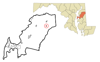
Galestown is a town in Dorchester County, Maryland, United States. The population was 138 at the 2010 census.

<span class="mw-page-title-main">Hurlock, Maryland</span> Town in Maryland, United States

Hurlock is a town in Dorchester County, Maryland, United States. The population was 2,092 at the 2010 census.

<span class="mw-page-title-main">Secretary, Maryland</span> Town in Maryland, United States

Secretary is a town in Dorchester County, Maryland, United States. The population was 535 at the 2010 census.

<span class="mw-page-title-main">Deer Park, Maryland</span> Town in Maryland, United States

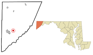
Deer Park is a town in Garrett County, Maryland, United States. The population was 399 at the 2010 census. It is part of the Pittsburgh Media Market.

<span class="mw-page-title-main">Kitzmiller, Maryland</span> Town in Maryland, United States

Kitzmiller is a town in Garrett County, Maryland, United States. The population was 321 at the 2010 census.

<span class="mw-page-title-main">Loch Lynn Heights, Maryland</span> Town in Maryland, United States

Loch Lynn Heights is a town in Garrett County, Maryland, United States. The population was 493 at the 2020 census.

<span class="mw-page-title-main">Mountain Lake Park, Maryland</span> Town in Maryland, United States

Mountain Lake Park is a town in Garrett County, Maryland, United States. The population was 2,147 as of the 2020 census.

<span class="mw-page-title-main">Barclay, Maryland</span> Town in Maryland, United States

Barclay is a town in Queen Anne's County, Maryland, United States. The population was 120 at the 2010 census.

<span class="mw-page-title-main">Queenstown, Maryland</span> Town in Maryland, United States

Queenstown is a town in Queen Anne's County, Maryland, United States. The population was 664 at the 2010 census.

<span class="mw-page-title-main">Mardela Springs, Maryland</span> Town in Maryland, United States

Mardela Springs is a town in Wicomico County, Maryland, United States. The population was 357 at the 2010 census. It is included in the Salisbury, Maryland-Delaware Metropolitan Statistical Area.

<span class="mw-page-title-main">Pittsville, Maryland</span> Town in Maryland, United States

Pittsville is a town in Wicomico County, Maryland, United States. The population was 1,417 at the 2010 census. It is included in the Salisbury, Maryland-Delaware Metropolitan Statistical Area.

<span class="mw-page-title-main">Sharptown, Maryland</span> Town in Maryland, United States

Sharptown is a town in Wicomico County, Maryland, United States. The population was 651 at the 2010 census. It is included in the Salisbury, Maryland-Delaware Metropolitan Statistical Area.

<span class="mw-page-title-main">Willards, Maryland</span> Town in Maryland, United States

Willards is a town in Wicomico County, Maryland, United States. The population was 958 at the 2010 census. It is included in the Salisbury, Maryland-Delaware Metropolitan Statistical Area.

<span class="mw-page-title-main">Markleysburg, Pennsylvania</span> Borough in Pennsylvania, United States

Markleysburg is a borough in Fayette County, Pennsylvania, United States. The population was 246 at the 2020 census. The borough is served by the Uniontown Area School District.

<span class="mw-page-title-main">Friendsville, Pennsylvania</span> Borough in Pennsylvania, United States

Friendsville is a borough in Susquehanna County, Pennsylvania, United States. The population was 100 at the 2020 census.

<span class="mw-page-title-main">Friendsville, Tennessee</span> City in Tennessee, United States

Friendsville is a city in Blount County, Tennessee. Its population was 896 at the 2020 census. It is included in the Knoxville, Tennessee Metropolitan Statistical Area.

References

  1. "Friendsville". Maryland Manual. Retrieved 24 June 2017.
  2. "2020 U.S. Gazetteer Files". United States Census Bureau. Retrieved April 26, 2022.
  3. 1 2 U.S. Geological Survey Geographic Names Information System: Friendsville, Maryland
  4. "US Gazetteer files 2010". United States Census Bureau. Archived from the original on 2012-07-02. Retrieved 2013-01-25.
  5. "Census of Population and Housing". Census.gov. Retrieved June 4, 2015.
  6. "U.S. Census website". United States Census Bureau . Retrieved 2013-01-25.
  7. "U.S. Census website". United States Census Bureau . Retrieved 2008-01-31.