Grantsville, Maryland

Last updated

Grantsville, Maryland
Casselman River Maryland.jpg
The Casselman River in Casselman River Bridge State Park near Grantsville, Maryland.
Seal of Grantsville, Maryland.png
Garrett County Maryland Incorporated and Unincorporated areas Grantsville Highlighted.svg
Location of Grantsville, Maryland
Coordinates: 39°41′49″N79°09′10″W / 39.69694°N 79.15278°W / 39.69694; -79.15278
Country United States
State Maryland
County Garrett
Incorporated 1864 [1]
Area
[2]
  Total1.04 sq mi (2.69 km2)
  Land1.04 sq mi (2.69 km2)
  Water0.00 sq mi (0.00 km2)
Elevation
[3]
2,303 ft (702 m)
Population
 (2020)
  Total968
  Density933.46/sq mi (360.43/km2)
Time zone UTC-5 (Eastern (EST))
  Summer (DST) UTC-4 (EDT)
ZIP code
21536
Area code(s) 301, 240
FIPS code 24-34525
GNIS feature ID2390215 [3]
Website www.visitgrantsville.com

Grantsville is a town in the northern part of Garrett County, Maryland, United States, near the Pennsylvania border. The population was 968 as of the 2020 census.

Contents

History

Grantsville, half a mile west of the Casselman River, began as a small Amish and Mennonite settlement, called Tomlinson's or Little Crossing, along Braddock Road, which wound westward from Cumberland over Negro Mountain. Later a new village flourished as a stop along the nearby National Road, U.S. Route 40. From 1818, the national road carried hundreds of thousands of pioneers and settlers in stagecoaches and covered wagons. In the 1800s, an area just outside Grantsville (once known as Little Crossing but now marked by the intersection of Route 40 and River Road) was a major stop on the old National Pike. There is a "dip" in the road that travelers will not miss when they pass through Little Crossing on Route 40.

The Casselman Bridge Casselmanbridge.jpg
The Casselman Bridge

Signs mark the location of the post office and the blacksmith shop that stayed open all night to fix broken horseshoes. An 1879 article in Harper's Monthly described the wagons as "so numerous that the leaders of one team had their noses in the trough at the end of the next wagon ahead."

The Casselman Inn sits in the center of town, where it has provided food and lodging to travelers since 1824. A sign outside displays a replica 1842 stagecoach advertisement.

Near the Casselman Bridge, a historic stone arch bridge, are Penn Alps Restaurant and The Spruce Forest Artisan Village, which was founded in 1957 by Alta Schrock. Penn Alps Restaurant is housed in the last log hospitality house on the National Pike. It is situated between a 1797 gristmill and the Casselman Bridge, the longest single span of stone in America when built in 1813.

Spruce Forest Artisan Village, a part of the extended Penn Alps campus, has grown from a few cabins to some 12 log and frame structures of early vintage, two of which date to the Revolutionary War Period. Most of these provide studio space for artisans. Artisans work in various media, including bird carving, stained glass, basket making, hand-loom weaving, and hand-thrown pottery.

Transportation

I-68/US 40 westbound and US 219 southbound at the exit for MD 495 in Grantsville 2021-08-02 10 23 11 View west along Interstate 68 and U.S. Route 40 and south along U.S. Route 219 (National Freeway) at Exit 19 (Maryland State Route 495, Grantsville, Swanton) in Grantsville, Garrett County, Maryland.jpg
I-68/US 40 westbound and US 219 southbound at the exit for MD 495 in Grantsville

The main mode of transportation to Grantsville is by road. Interstate 68, U.S. Route 40 and U.S. Route 219 all traverse Grantsville via the National Freeway, an east-west freeway traversing western Maryland and northern West Virginia. Direct access to Grantsville is provided by an interchange with Maryland Route 495. U.S. Route 40 Alternate and Maryland Route 669 also serve Grantsville.

Grantsville was served by Greyhound bus until 2005. Since January 2011, it has been served by a Bayrunner Shuttle that originates in Grantsville and serves Frostburg, Cumberland, Allegany College of Maryland Cumberland Campus, Hancock, Hagerstown, Frederick Transit Center, Frederick Airport, BWI, BWI Amtrak Station, and Baltimore Greyhound Station.

Geography

According to the United States Census Bureau, the town has a total area of 0.98 square miles (2.54 km2), all land. [4]

Climate

Grantsville has a humid continental climate under the Köppen climate classification, with warm summers and cold winters. [5]

Demographics

Historical population
CensusPop.Note
1880 220
1900 175
1910 24841.7%
1920 2646.5%
1930 40051.5%
1940 46516.3%
1950 461−0.9%
1960 446−3.3%
1970 51715.9%
1980 498−3.7%
1990 5051.4%
2000 61922.6%
2010 76623.7%
2020 96826.4%
U.S. Decennial Census [6]

In the 1960s the town had a stable population of approximately 400 individuals.

2010 census

As of the census [7] of 2010, there were 766 people, 350 households, and 213 families living in the town. The population density was 781.6 inhabitants per square mile (301.8/km2). There were 397 housing units at an average density of 405.1 per square mile (156.4/km2). The racial makeup of the town was 98.3% White, 0.1% African American, 0.4% Native American, and 1.2% from two or more races. Hispanic or Latino of any race were 1.6% of the population.

There were 350 households, of which 32.3% had children under the age of 18 living with them, 39.1% were married couples living together, 17.1% had a female householder with no husband present, 4.6% had a male householder with no wife present, and 39.1% were non-families. 35.7% of all households were made up of individuals, and 19.5% had someone living alone who was 65 years of age or older. The average household size was 2.19 and the average family size was 2.77.

The median age in the town was 38.4 years. 23.5% of residents were under the age of 18; 11.1% were between the ages of 18 and 24; 22.9% were from 25 to 44; 22.7% were from 45 to 64; and 19.8% were 65 years of age or older. The gender makeup of the town was 47.1% male and 52.9% female.

2000 census

As of the census [8] of 2000, there were 619 people, 278 households, and 177 families living in the town. The population density was 877.2 inhabitants per square mile (338.7/km2). There were 298 housing units at an average density of 422.3 per square mile (163.1/km2). The racial makeup of the town was 98.87% White, 0.48% African American, 0.32% Asian, and 0.32% from two or more races. Hispanic or Latino of any race were 0.48% of the population.

There were 278 households, out of which 30.6% had children under the age of 18 living with them, 43.5% were married couples living together, 14.7% had a female householder with no husband present, and 36.0% were non-families. 33.1% of all households were made up of individuals, and 12.2% had someone living alone who was 65 years of age or older. The average household size was 2.22 and the average family size was 2.74.

In the town, the population was spread out, with 24.4% under the age of 18, 8.2% from 18 to 24, 28.9% from 25 to 44, 24.1% from 45 to 64, and 14.4% who were 65 years of age or older. The median age was 37 years. For every 100 females, there were 86.4 males. For every 100 females age 18 and over, there were 85.0 males.

The median income for a household in the town was $27,778, and the median income for a family was $35,000. Males had a median income of $29,167 versus $21,250 for females. The per capita income for the town was $15,625. About 22.2% of families and 23.8% of the population were below the poverty line, including 38.0% of those under age 18 and 8.8% of those age 65 or over.

Notable people

Related Research Articles

<span class="mw-page-title-main">Garrett County, Maryland</span> County in Maryland, United States

Garrett County is the westernmost county of the U.S. state of Maryland completely within the Appalachian Mountains. As of the 2020 census, the population was 28,806, making it the third-least populous county in Maryland. Its county seat is Oakland. The county was named for John Work Garrett (1820–1884), president of the Baltimore and Ohio Railroad. Created from Allegany County in 1872, it was the last county to be formed in the state.

<span class="mw-page-title-main">Oakland, Maryland</span> Town in Maryland, United States

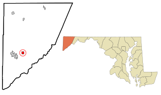
Oakland is a town in and the county seat of Garrett County, Maryland, United States. The population was 1,851 at the 2020 census. It is situated only miles from the source of the Potomac River, which flows directly into Chesapeake Bay. It is also near the Wisp Resort at Deep Creek Lake. Oakland is part of the Pittsburgh media market.

<span class="mw-page-title-main">Fenwick Island, Delaware</span> Town in Delaware, United States

Fenwick Island is a coastal resort town in Sussex County, Delaware, United States. According to 2020 census figures, the population of the town is 355, a 2.6% decrease over the last decade. It is part of the Salisbury, Maryland–Delaware Metropolitan Statistical Area. The town is located on Fenwick Island, a barrier spit.

<span class="mw-page-title-main">Alta Vista, Kansas</span> City in Wabaunsee County, Kansas

Alta Vista is a city in Wabaunsee County, Kansas, United States. As of the 2020 census, the population of the city was 409.

<span class="mw-page-title-main">Westernport, Maryland</span> Town in Maryland, United States

Westernport is a town in Allegany County, Maryland, United States, along the Georges Creek Valley. It is part of the Cumberland, MD-WV Metropolitan Statistical Area. The population was 1,888 at the 2010 census.

<span class="mw-page-title-main">Ferndale, Maryland</span> Census-designated place in Maryland, United States

Ferndale is a census-designated place (CDP) in Anne Arundel County, Maryland, United States. At the 2010 census, the population was 16,746.

<span class="mw-page-title-main">Preston, Maryland</span> Town in Maryland

Preston is a town in Caroline County, Maryland, United States. The population was 719 at the 2010 census.

<span class="mw-page-title-main">North East, Maryland</span> Town in Maryland, United States

North East is a town in Cecil County, Maryland, United States. It is located between Philadelphia and Baltimore. The population was 3,572 at the 2010 census.

<span class="mw-page-title-main">Deer Park, Maryland</span> Town in Maryland, United States

Deer Park is a town in Garrett County, Maryland, United States. The population was 399 at the 2010 census. It is part of the Pittsburgh Media Market.

<span class="mw-page-title-main">Mountain Lake Park, Maryland</span> Town in Maryland, United States

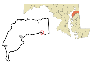
Mountain Lake Park is a town in Garrett County, Maryland, United States. The population was 2,147 as of the 2020 census.

<span class="mw-page-title-main">Barnesville, Maryland</span> Town in Maryland, United States

Barnesville is a town in Montgomery County, Maryland, United States. It was incorporated in 1888. The population was 144 at the 2020 census.

<span class="mw-page-title-main">Hancock, Maryland</span> Town in Maryland, United States

Hancock is a town in Washington County, Maryland, United States. The population was 1,557 at the 2020 census. The Western Maryland community is notable for being located at the narrowest part of the state. The north–south distance from the Pennsylvania state line to the West Virginia state line is only 1.8 miles (2.9 km) at Hancock.

<span class="mw-page-title-main">Mardela Springs, Maryland</span> Town in Maryland, United States

Mardela Springs is a town in Wicomico County, Maryland, United States. The population was 357 at the 2010 census. It is included in the Salisbury, Maryland-Delaware Metropolitan Statistical Area.

<span class="mw-page-title-main">West Ocean City, Maryland</span> CDP in Maryland, United States

West Ocean City is a census-designated place (CDP) in Worcester County, Maryland, United States. The population was 4,375 at the 2010 census. It is part of the Salisbury, Maryland-Delaware Metropolitan Statistical Area.

<span class="mw-page-title-main">Casselman, Pennsylvania</span> Borough in Pennsylvania, United States

Casselman is a borough in Somerset County, Pennsylvania, United States.

<span class="mw-page-title-main">Upper Turkeyfoot Township, Pennsylvania</span> Township in Pennsylvania, United States

Upper Turkeyfoot Township is a township in Somerset County, Pennsylvania, United States. The population was 1,063 at the 2020 census. It is part of the Johnstown, Pennsylvania metropolitan statistical area.

<span class="mw-page-title-main">Grantsville, West Virginia</span> Town in West Virginia, United States

Grantsville is a town in Calhoun County, West Virginia, United States. The population was 482 at the 2020 census. It is the county seat of Calhoun County. The town was established along the Little Kanawha River in 1865 and named for Ulysses S. Grant. Grantsville is home to Wayne Underwood Park, which includes a .25-mile-long (0.40 km) walking trail, and to the annual West Virginia Wood Festival.

<span class="mw-page-title-main">Bayard, West Virginia</span> Town in West Virginia, United States

Bayard is a town in Grant County, West Virginia, United States. The population was 200 at the 2020 census. Bayard was incorporated in 1893 and named in honor of Thomas F. Bayard, Jr., who later became a United States senator from Delaware (1923–1929). Bayard was founded on the West Virginia Central and Pittsburgh Railroad as a coal mining community. Coal mining has remained the town's chief industry.

<span class="mw-page-title-main">Terra Alta, West Virginia</span> Town in West Virginia, United States

Terra Alta is a town in eastern Preston County, West Virginia, United States. The population was 1,415 at the 2020 census. It is part of the Morgantown metropolitan area.

<span class="mw-page-title-main">Millington, Maryland</span> Town in Maryland, United States

Millington is a town in Kent and Queen Anne's counties in the U.S. state of Maryland. The population was 642 at the 2010 census. Millington is the head of navigation for the Chester River.

References

  1. "Grantsville". Maryland Manual. Retrieved June 24, 2017.
  2. "2020 U.S. Gazetteer Files". United States Census Bureau. Retrieved April 26, 2022.
  3. 1 2 U.S. Geological Survey Geographic Names Information System: Grantsville, Maryland
  4. "US Gazetteer files 2010". United States Census Bureau. Archived from the original on January 25, 2012. Retrieved January 25, 2013.
  5. "Grantsville climate: Average Temperature, weather by month, Grantsville weather averages - Climate-Data.org". en.climate-data.org. Retrieved June 18, 2019.
  6. "Census of Population and Housing". Census.gov. Retrieved June 4, 2015.
  7. "U.S. Census website". United States Census Bureau . Retrieved January 25, 2013.
  8. "U.S. Census website". United States Census Bureau . Retrieved January 31, 2008.
  9. "Alta Schrock, Maryland Women's Hall of Fame" . Retrieved March 21, 2016.