Accident, Maryland

Last updated

Accident, Maryland
JamesDraneHouse2012.jpg
Seal of Accident, Maryland.png
Garrett County Maryland Incorporated and Unincorporated areas Accident Highlighted.svg
Location of Accident, Maryland
USA Maryland location map.svg
Red pog.svg
Accident, Maryland
Usa edcp location map.svg
Red pog.svg
Accident, Maryland
North America laea location map.svg
Red pog.svg
Accident, Maryland
Coordinates: 39°37′41″N79°19′12″W / 39.62806°N 79.32000°W / 39.62806; -79.32000
Country Flag of the United States.svg United States
State Flag of Maryland.svg  Maryland
County Flag of Garrett County, Maryland.svg Garrett
Patented1786 [1]
Incorporated 1916 [1]
Area
[2]
  Total0.49 sq mi (1.28 km2)
  Land0.49 sq mi (1.28 km2)
  Water0.00 sq mi (0.00 km2)
Elevation
[3]
2,356 ft (718 m)
Population
 (2020)
  Total338
  Density684.21/sq mi (263.97/km2)
Demonym Accidental
Time zone UTC-5 (Eastern (EST))
  Summer (DST) UTC-4 (EDT)
ZIP code
21520
Area codes 301, 240
FIPS code 24-00225
GNIS feature ID2390695 [3]
Website www.accidentmd.org

Accident is a town in Garrett County, Maryland, United States. The population was 338 at the 2020 United States census. [4] Accident has been noted for its unusual place name. [5] A person from Accident is called an "Accidental". [6]

Contents

History

Accident was one of the early settlements in the far west of Maryland. The name originates about the time of the 1786 land survey. Though the origin or meaning of the name is unknown, one popular story says that Brooke Beall and William Deakins, Jr., [lower-alpha 1] friends from Prince George's County, were conducting separate surveys in the area at the time and "by accident" Deakins claimed land already surveyed by Beall. [1] [8]

When Lord Baltimore opened up the area, which he called Monocacy Manor, for settlement, in the early 1770s, Brooke Beall secured permission to survey 778 acres (315 hectares; 1.216 square miles). It will never be known for certain how Beall came to choose this particular spot, but the surveyor was given clear instructions where to start. He was to begin "in the center between two bounded white oak trees, standing on the North Side of the South fork of Bear Creek in or near a glade about one Hundred yards from said Run, about one or two Miles above a Lick known by the name of the "Cole Mine Lick", about four miles (6.4 km) above the mouth of Broad Creek and about one mile (1.6 km) East of a Ridge of the Negro Mountain." John Hanson, Jr., later a delegate to the Continental Congress, and President of the United States in Congress Assembled, on April 14, 1774, surveyed the land, finding that it only contained 682 acres (276 hectares). For the next twelve years, nothing was done with the survey. The American Revolutionary War intervened, and it was not until February 15, 1786, that the land was granted by means of a patent to William Deakins. The following year the surrounding countryside was surveyed into military lots by Francis Deakins, lots that were meant as compensation for the soldiers who served from Maryland during the Revolution. Each soldier who served for two years received one lot of 50 acres (20 hectares), officers received four lots of 50 acres (20 hectares) each. [lower-alpha 2]

Detail from the original Francis Deakins 1787 survey of lots westward of Fort Cumberland, Library of Congress. Reproduced in Edward C. Papenfuse and Joseph M. Coale, The Maryland State Archives Atlas of Historical Maps of Maryland, (Baltimore: Johns Hopkins University Press, 2003), p. 204 Accident detail deakins 1787 02.jpg
Detail from the original Francis Deakins 1787 survey of lots westward of Fort Cumberland, Library of Congress. Reproduced in Edward C. Papenfuse and Joseph M. Coale, The Maryland State Archives Atlas of Historical Maps of Maryland, (Baltimore: Johns Hopkins University Press, 2003), p. 204

Kaese Mill was listed on the National Register of Historic Places in 1984. [10] The James Drane House was listed in 1985. [10]

Geography

According to the United States Census Bureau, the town has a total area of 0.49 square miles (1.27 km2), all land. [11]

Accident is located in the plateau region of the Appalachian Mountains.

Demographics

Historical population
CensusPop.Note
1880 114
1940 236
1950 2422.5%
1960 237−2.1%
1970 2370.0%
1980 2463.8%
1990 34941.9%
2000 3531.1%
2010 325−7.9%
2020 311−4.3%
U.S. Decennial Census [12]

2010 census

As of the census [13] of 2010, there were 325 people, 141 households, and 86 families residing in the town. The population density was 663.3 inhabitants per square mile (256.1/km2). There were 173 housing units at an average density of 353.1 per square mile (136.3/km2). The racial makeup of the town was 97.8% White, 0.6% Native American, 0.3% Asian, 0.6% from other races, and 0.6% from two or more races. Hispanic or Latino of any race were 0.6% of the population.

There were 141 households, of which 33.3% had children under the age of 18 living with them, 45.4% were married couples living together, 11.3% had a female householder with no husband present, 4.3% had a male householder with no wife present, and 39.0% were non-families. 32.6% of all households were made up of individuals, and 19.1% had someone living alone who was 65 years of age or older. The average household size was 2.30 and the average family size was 2.99.

The median age in the town was 34.5 years. 26.2% of residents were under the age of 18; 10.1% were between the ages of 18 and 24; 25.3% were from 25 to 44; 22.8% were from 45 to 64; and 15.7% were 65 years of age or older. The gender makeup of the town was 45.5% male and 54.5% female.

2000 census

As of the census [14] of 2000, there were 353 people, 138 households, and 96 families residing in the town. The population density was 711.1 inhabitants per square mile (274.6/km2). There were 162 housing units at an average density of 326.3 per square mile (126.0/km2). The racial makeup of the town was 99.72% White and 0.28% from two or more races.

There were 138 households, out of which 37.7% had children under the age of 18 living with them, 54.3% were married couples living together, 12.3% had a female householder with no husband present, and 30.4% were non-families. 28.3% of all households were made up of individuals, and 21.7% had someone living alone who was 65 years of age or older. The average household size was 2.56 and the average family size was 3.14.

In the town, the population was spread out, with 29.2% under the age of 18, 7.1% from 18 to 24, 22.4% from 25 to 44, 18.4% from 45 to 64, and 22.9% who were 65 years of age or older. The median age was 38 years. For every 100 females, there were 73.9 males. For every 100 females age 18 and over, there were 73.6 males.

The median income for a household in the town was $22,500, and the median income for a family was $40,556. Males had a median income of $25,250 versus $18,750 for females. The per capita income for the town was $11,950. About 10.9% of families and 17.5% of the population were below the poverty line, including 17.3% of those under age 18 and 24.1% of those age 65 or over.

Transportation

US 219 northbound in Accident 2021-08-07 17 31 21 View north along U.S. Route 219 (Main Street) just north of Cemetery Road in Accident, Garrett County, Maryland.jpg
US 219 northbound in Accident

The primary method of transportation to and from Accident is by road. One state-maintained highway, U.S. Route 219, serves the town directly, following Main Street through the middle of Accident. To the north, US 219 connects Accident to Interstate 68 and U.S. Route 40, along with the town of Grantsville, before heading into Pennsylvania. Heading south, US 219 connects to Maryland Route 42, Maryland Route 39, Maryland Route 135 and U.S. Route 50, along with the towns of Oakland and Mountain Lake Park, before it enters West Virginia.

Notable people

Notes

  1. Deakins later served as a delegate to the Maryland State Convention of 1788, to vote whether Maryland should ratify the proposed Constitution of the United States. [7]
  2. Mr. George Deakins was to receive 600 acres of land in Western Maryland as a payment of a debt from King George II of Great Britain. Mr. Deakins sent out two corps of engineers, each without knowledge of the other, to survey the best land in this area. Both crews returned and to their surprise, they had both marked the same Oak tree as their starting and returning points. Mr. Deakins chose this plot of ground and had it patented "The Accident Tract". Now called, the Town of Accident! Accident was incorporated in 1916. [9]

Related Research Articles

<span class="mw-page-title-main">Midland, Maryland</span> Town in Maryland, United States

Midland is a town in Allegany County, Maryland, United States, along the Georges Creek Valley. It is part of the Cumberland, MD-WV Metropolitan Statistical Area. The population was 446 at the 2010 census. Midland was founded in 1850 as a coal-mining community, though today only some strip mining remains.

<span class="mw-page-title-main">Westernport, Maryland</span> Town in Maryland, United States

Westernport is a town in Allegany County, Maryland, United States, along the Georges Creek Valley. It is part of the Cumberland, MD-WV Metropolitan Statistical Area. The population was 1,888 at the 2010 census.

<span class="mw-page-title-main">Denton, Maryland</span> Town in Maryland

Denton is a town in Caroline County, Maryland, United States. The population of Denton was 4,418 as of the 2010 United States Census, and it is the county seat of Caroline County.

<span class="mw-page-title-main">Greensboro, Maryland</span> Town in Maryland

Greensboro is a town located on the banks of the Choptank River in Caroline County, Maryland, United States. The population was 1,931 at the 2010 United States Census. The ZIP code is 21639. The primary phone exchange is 482 and the area code is 410. The town is served by Maryland Routes 480 and 313.

<span class="mw-page-title-main">Middletown, Maryland</span> Town in Maryland

Middletown is a town in Frederick County, Maryland, United States. The population was 4,136 as of the 2010 census. Located in the Middletown Valley that stretches between the Catoctin Mountains on the east and South Mountain on the west, the town reportedly gained its name from its location midway between those ranges.

<span class="mw-page-title-main">Kitzmiller, Maryland</span> Town in Maryland, United States

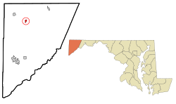
Kitzmiller is a town in Garrett County, Maryland, United States. The population was 321 at the 2010 census.

<span class="mw-page-title-main">Mountain Lake Park, Maryland</span> Town in Maryland, United States

Mountain Lake Park is a town in Garrett County, Maryland, United States. The population was 2,147 as of the 2020 census.

<span class="mw-page-title-main">Burtonsville, Maryland</span> Census-designated place in Maryland

Burtonsville is a census-designated place and an unincorporated area in Montgomery County, Maryland, United States. It is situated in the northeast corner of Montgomery County, right on the border of both Howard and Prince George's counties. It is considered a suburban town in the Washington D.C. Metro Area.

<span class="mw-page-title-main">Cloverly, Maryland</span> Census-designated place in Maryland, United States

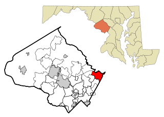
Cloverly is an unincorporated town and census-designated place in Montgomery County, Maryland, United States. Its population was 15,285 as of the 2020 census.

<span class="mw-page-title-main">Colesville, Maryland</span> Census-designated place in Maryland, United States

Colesville is a census-designated place and an unincorporated area in Montgomery County, Maryland, United States. It had a population of 15,421 as of the 2020 census.

<span class="mw-page-title-main">Poolesville, Maryland</span> Town in Maryland, United States

Poolesville is a U.S. town in the western portion of Montgomery County, Maryland. The population was 5,742 at the 2020 United States Census. It is surrounded by the Montgomery County Agricultural Reserve, and is considered a distant bedroom community for commuters to Washington, D.C.

<span class="mw-page-title-main">Somerset, Maryland</span> Town in Maryland, United States

Somerset is an incorporated town in Montgomery County, Maryland, United States, located near the border with Washington, D.C. The population was 1,187 at the 2020 census.

<span class="mw-page-title-main">Brentwood, Maryland</span> Town in Prince Georges County, Maryland, US

Brentwood is a town in Prince George's County, Maryland, United States. Per the 2020 census, the population was 3,828. Brentwood is located within 1-mile (1.6 km) of Washington. The municipality of Brentwood is located just outside the northeast boundary of the District of Columbia and surrounded by the communities of Mount Rainier, Cottage City, North Brentwood, and the nearby Hyattsville. Along the Route 1 Corridor, Brentwood is part of the Gateway Arts District.

<span class="mw-page-title-main">University Park, Maryland</span> Town in Maryland

University Park is a town in Prince George's County, Maryland, United States. The population was 2,454 at the 2020 census.

<span class="mw-page-title-main">Boonsboro, Maryland</span> Town in Maryland, United States

Boonsboro is a town in Washington County, Maryland, United States, located at the foot of South Mountain. It nearly borders Frederick County and is proximate to the Antietam National Battlefield. The population was 3,779 at the 2020 census.

<span class="mw-page-title-main">Paramount-Long Meadow, Maryland</span> CDP in Maryland, United States

Paramount-Long Meadow is a census-designated place (CDP) in Washington County, Maryland, United States. The population was 2,722 at the 2000 census.

<span class="mw-page-title-main">Elk Garden, West Virginia</span> Town in West Virginia, United States

Elk Garden is a town in Mineral County, West Virginia, United States. It is part of the 'Cumberland, MD-WV Metropolitan Statistical Area'. The population was 211 at the 2020 census. Elk Garden High School was consolidated into Keyser High School in 1997. However the Primary School is still in session, offering classes from Pre-Kindergarten through the fifth grade. The school mascot is the Elk Garden Stags. Elk Garden was incorporated in 1890 by the Mineral County Circuit Court. It is named for an elk lick near the original town site.

<span class="mw-page-title-main">Queen Anne, Maryland</span> Town in Maryland, United States of America

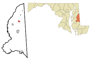
Queen Anne is a town in Queen Anne's and Talbot counties in the U.S. state of Maryland. The population was 222 at the 2010 census.

<span class="mw-page-title-main">Chevy Chase (town), Maryland</span> Town in Montgomery County, Maryland, US

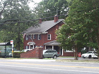
Chevy Chase —formally, the Town of Chevy Chase—is an incorporated town in Montgomery County, Maryland, United States. The population was 2,904 at the 2020 census.

<span class="mw-page-title-main">Dranesville, Virginia</span> Census-designated place in Virginia, United States

Dranesville is a census-designated place (CDP) in Fairfax County, Virginia, United States. Dranesville is located on the Leesburg Pike at its intersection with Georgetown Pike. The U.S. Census Bureau defines Dranesville as a census-designated place (CDP) with a population of 11,921 as of 2010. At the 2020 Census the population was 11,785.

References

  1. 1 2 3 "Accident". Maryland Manual. Retrieved June 24, 2017.
  2. "2020 U.S. Gazetteer Files". United States Census Bureau. Retrieved April 26, 2022.
  3. 1 2 U.S. Geological Survey Geographic Names Information System: Accident, Maryland
  4. "Accident town, Maryland". United States Census Bureau. Retrieved January 23, 2022.
  5. "The Oddest Named Town in Every State". The Active Times. April 19, 2018. Retrieved July 3, 2019.
  6. Dickson, Paul (2006). Labels for Locals: What to Call People from Abilene to Zimbabwe. Harper Collins. p. 3. ISBN   9780060881641.
  7. Secretary of State of Maryland (1915). Maryland Manual 1914–1915: A Compendium of Legal, Historical and Statistical Information relating to the State of Maryland. Annapolis: The Advertiser-Republican.
  8. "How did this spot get the name "Accident?" Mary Strauss in Flowery Vale: A History of Accident, Maryland,(Parson, West Virginia: McClain Printing Col, 1986), p. 1, provides an interesting story of axe marks on a tree, and conflicting claims, "A Pictorial History of Accident, Maryland, from the collection of Mary Miller Strauss". Western Maryland's Historical Society. Archived from the original on September 27, 2007. Retrieved March 29, 2008.
  9. Scharf, J. Thomas (1882). History of Western Maryland. Philadelphia: Louis A. Everts
  10. 1 2 "National Register Information System". National Register of Historic Places . National Park Service. April 15, 2008.
  11. "US Gazetteer files 2010". United States Census Bureau. Archived from the original on July 2, 2012. Retrieved January 25, 2013.
  12. "Census of Population and Housing". Census.gov. Retrieved June 4, 2015.
  13. "U.S. Census website". United States Census Bureau . Retrieved January 25, 2013.
  14. "U.S. Census website". United States Census Bureau . Retrieved January 31, 2008.