Garrett County is the westernmost county of the U.S. state of Maryland completely within the Appalachian Mountains. As of the 2020 census, the population was 28,806, making it the third-least populous county in Maryland. Its county seat is Oakland. The county was named for John Work Garrett (1820–1884), president of the Baltimore and Ohio Railroad. Created from Allegany County in 1872, it was the last county to be formed in the state.

The Potomac River is a major river in the Mid-Atlantic region of the United States that flows from the Potomac Highlands in West Virginia to the Chesapeake Bay in Maryland. It is 405 miles (652 km) long, with a drainage area of 14,700 square miles (38,000 km2), and is the fourth-largest river along the East Coast of the United States and the 21st-largest in the United States. More than 5 million people live within its watershed.

U.S. Route 50 or U.S. Highway 50 (US 50) is a major east–west route of the U.S. Highway system, stretching 3,019 miles (4,859 km) from Interstate 80 (I-80) in West Sacramento, California, to Maryland Route 528 in Ocean City, Maryland, on the Atlantic Ocean. Until 1972, when it was replaced by Interstate Highways west of the Sacramento area, it extended to San Francisco, near the Pacific Ocean. The Interstates were constructed later and are mostly separate from this route. It generally serves a corridor south of I-70 and I-80 and north of I-64 and I-40.

The Shenandoah River is the principal tributary of the Potomac River, 55.6 miles (89.5 km) long with two forks approximately 100 miles (160 km) long each, in the U.S. states of Virginia and West Virginia. The river and its tributaries drain the central and lower Shenandoah Valley and the Page Valley in the Appalachians on the west side of the Blue Ridge Mountains, in northwestern Virginia and the Eastern Panhandle of West Virginia. There is a hydroelectric plant along the Shenandoah river constructed in 2014 by Dominion.

U.S. Route 522 is a spur route of US 22 in the states of Virginia, West Virginia, Maryland, and Pennsylvania. The U.S. Highway travels in a north-south direction, and runs 308.59 miles (496.63 km) from US 60 near Powhatan, Virginia, to its northern terminus at US 11 and US 15 near Selinsgrove, Pennsylvania. US 522 serves many small cities and towns in the Piedmont, Blue Ridge Mountains, and northern Shenandoah Valley of Virginia. The highway serves the Virginia communities of Goochland, Mineral, Culpeper, the town of Washington, and Front Royal and the independent city of Winchester. US 522 then follows the Ridge-and-Valley Appalachians north and then east through the Eastern Panhandle of West Virginia, a 2-mile-wide (3.2 km) stretch of Western Maryland, and South Central Pennsylvania to its terminus in the Susquehanna Valley. The highway serves Berkeley Springs, West Virginia; Hancock, Maryland; and the Pennsylvania communities of McConnellsburg, Mount Union, Lewistown, and Middleburg.

U.S. Route 340 is a spur route of US 40, and runs from Greenville, Virginia, to Frederick, Maryland. In Virginia, it runs north–south, parallel and east of US 11, from US 11 north of Greenville via Waynesboro, Grottoes, Elkton, Luray, Front Royal, and Berryville to the West Virginia state line. A short separate piece crosses northern Loudoun County on its way from West Virginia to Maryland.

Arthur Pue Gorman was an American politician. He was leader of the Gorman-Rasin organization with Isaac Freeman Rasin that controlled the Maryland Democratic Party from the late 1870s until his death in 1906. Gorman served as United States Senator from Maryland from 1881 to 1899 and again from 1903 until his death. He was a prominent leader of the Bourbon Democrat faction of the Democratic Party. Gorman was Chairman of the Democratic National Committee during Grover Cleveland's 1884 presidential campaign and he is widely credited with securing Cleveland's victory. In 1952 Gorman was described in The Baltimore Sun as "easily the most powerful political figure [Maryland] has ever known."
The Northwestern Turnpike is a historic road in West Virginia, important for being historically one of the major roads crossing the Appalachians, financed by the Virginia Board of Public Works in the 1830s. In modern times, west of Winchester, Virginia, U.S. Route 50 follows the path of the Northwestern Turnpike into West Virginia, whose major Corridor D project follows the western section of the original Northwestern Turnpike.

Green Spring is a census-designated place (CDP) and railroad town in Hampshire County, West Virginia, United States. As of the 2010 census, its population was 218. Green Spring is located north of Springfield on Green Spring Road near the confluence of the North and South Branches of the Potomac River. Green Spring is also the location of the South Branch Valley Railroad's terminus with the old Baltimore & Ohio Railroad mainline. Green Spring is the site of a one-lane low-water toll bridge that connects Green Spring Road to Maryland Route 51 in Oldtown, Allegany County, Maryland. This bridge is one of only 17 privately owned toll bridges in the United States. The toll for the bridge is currently US$1.50.
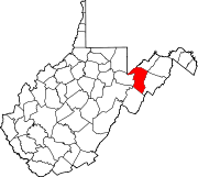
West Virginia Route 90 is a 13-mile (21 km) long north–south state highway in the Eastern Panhandle of West Virginia. The route, located within Tucker County and Grant County, runs parallel to the Maryland state line for most of its length. The southern terminus of the route is at U.S. Route 219 one mile north of Thomas. The northern terminus is at U.S. Route 50 in Gormania less than 200 yards (180 m) east of the North Branch Potomac River.

Gorman is a census-designated place (CDP) along the North Branch Potomac River in southern Garrett County, Maryland, United States. As of the 2010 census, Gorman's population was 106. Gorman lies on Gorman Road off the Northwestern Turnpike, which crosses the North Branch into Gormania, West Virginia, via Gormania Bridge. Like Gormania, the town is named for United States Senator from Maryland, Arthur Pue Gorman.
U.S. Route 50 in West Virginia runs from the border with Ohio to Virginia, passing briefly through Garrett County, Maryland, and following the Northwestern Turnpike. Prior to the U.S. Highway System it was West Virginia Route 1 and in the 1930s, the road was not finished in Maryland. Today the section of US 50 from Clarksburg to Parkersburg on the Ohio River is part of Corridor D of the Appalachian Development Highway System.

U.S. Route 301 (US 301) in the state of Maryland is a major highway that runs 122.85 miles (197.71 km) from the Governor Harry W. Nice Memorial Bridge over the Potomac River into Virginia northeast to Delaware. It passes through three of Maryland's four main regions: Southern Maryland, the Baltimore-Washington Metropolitan Area, and the Eastern Shore. US 301 serves mainly as a bypass of Baltimore and Washington, D.C. from Virginia to Delaware.
Canal Parkway, which carries the unsigned Maryland Route 61 designation, is a state highway and automobile parkway in the U.S. state of Maryland. The road begins at the West Virginia state line at the North Branch Potomac River opposite Wiley Ford, where the highway continues south as West Virginia Route 28. The parkway runs 1.94 miles (3.12 km) north to MD 51 within the city of Cumberland. Canal Parkway provides a connection between downtown Cumberland and the South Cumberland neighborhood and with Greater Cumberland Regional Airport, which is located in Mineral County, West Virginia.

Maryland Route 560 is a state highway in the U.S. state of Maryland. Known for most of its length as Gorman Road, the state highway runs 9.32 miles (15.00 km) from U.S. Route 50 in Gorman north to MD 135 in Mountain Lake Park. MD 560 serves as the main street of Loch Lynn Heights. The state highway also provides a connection through southeastern Garrett County between US 50 on the east side of Backbone Mountain and the Oakland area. MD 560 was constructed from both ends beginning in the early 1930s. The northern segment was extended over Backbone Mountain in the late 1930s, but it was not until 1949 that the gap in MD 560 was filled.
Woodstock is an unincorporated community which is a suburb of Baltimore, Maryland, United States. The original village of Woodstock is located in Howard County, and also includes portions of Baltimore County and Carroll County.

U.S. Route 220 is a part of the U.S. Highway System that runs from Rockingham, North Carolina, to South Waverly, Pennsylvania. In Maryland, the federal highway runs 27.30 miles (43.94 km) from the West Virginia state line at the North Branch Potomac River in McCoole north to the Pennsylvania state line in Dickens. Known as McMullen Highway for much of its length in Maryland, US 220 is the primary north–south route in central Allegany County, connecting Cumberland with its southern suburbs and Keyser, West Virginia, to the south and Bedford, Pennsylvania, to the north. The federal highway is part of the National Highway System between the West Virginia state line and Maryland Route 53 in Cresaptown and between Interstate 68 (I-68), with which it is concurrent through Cumberland, and the Pennsylvania state line.

Gormania Presbyterian Church, now known as Gormania United Methodist Church, is a historic Presbyterian church on Mabis Avenue, 0.1 miles south of US 50 in Gormania, Grant County, West Virginia. It was built in 1888, and is a single-story ornate wooden structure in a late form of the Gothic Revival style. It features a corner entrance bell tower and tall spire. A rear addition including three Sunday school rooms was built in 1925. It was occupied by a Presbyterian congregation until the 1980s. In 1994, the Gormania United Methodist Church purchased the building.

The North Branch Potomac River flows from Fairfax Stone in West Virginia to its confluence with the South Branch Potomac River near Green Spring, West Virginia, where it turns into the Potomac River proper.
 Gormania, viewed from US 50 bridge, 1940s
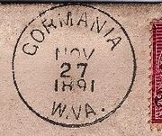 Gormania postmark