Terra Alta, West Virginia

Last updated

Terra Alta, West Virginia
Terra Alta Bank.jpg
Preston County West Virginia Incorporated and Unincorporated areas Terra Alta Highlighted.svg
Location of Terra Alta in Preston County, West Virginia.
Coordinates: 39°26′40″N79°32′38″W / 39.44444°N 79.54389°W / 39.44444; -79.54389
Country United States
State West Virginia
County Preston
Government
  MayorDan Hauger. [1]
Area
[2]
  Total1.19 sq mi (3.07 km2)
  Land1.19 sq mi (3.07 km2)
  Water0.00 sq mi (0.00 km2)
Elevation
[3]
2,582 ft (787 m)
Population
 (2020) [4]
  Total1,415
  Estimate 
(2021) [4]
1,498
  Density1,265.82/sq mi (488.64/km2)
Time zone UTC-5 (Eastern (EST))
  Summer (DST) UTC-4 (EDT)
ZIP code
26764
Area code 304
FIPS code 54-79708 [5]
GNIS feature ID1547983 [3]
Website https://terraalta.wv.gov/Pages/default.aspx

Terra Alta is a town in eastern Preston County, West Virginia, United States. The population was 1,415 at the 2020 census. [6] It is part of the Morgantown metropolitan area.

Contents

History

James S. Lakin House James S. Lakin House.jpg
James S. Lakin House

Terra Alta was originally called Portland, and under the latter name had its start in the 1850s. [7] The present name Terra Alta is derived from Latin meaning "high land". [8] According to the 1876 Baltimore and Ohio Railroad map, Terra Alta had a railroad station called Cranberry Station.

The town is home to the James S. Lakin House and Terra Alta Bank, each listed on the National Register of Historic Places. [9]

Geography

Terra Alta is located at 39°26′40″N79°32′38″W / 39.44444°N 79.54389°W / 39.44444; -79.54389 (39.444343, -79.544002). [10]

According to the United States Census Bureau, the town has a total area of 1.19 square miles (3.08 km2), all land. [11]

Climate

The climate in this area has mild differences between highs and lows, and there is adequate rainfall year-round. According to the Köppen Climate Classification system, Terra Alta has a humid continental climate, abbreviated "Dfb" on climate maps. [12]

Climate data for Terra Alta, West Virginia (1991–2020 normals, extremes 1948–2020)
MonthJanFebMarAprMayJunJulAugSepOctNovDecYear
Record high °F (°C)72
(22)
74
(23)
81
(27)
88
(31)
89
(32)
91
(33)
95
(35)
94
(34)
93
(34)
84
(29)
78
(26)
74
(23)
95
(35)
Mean maximum °F (°C)59.0
(15.0)
60.7
(15.9)
69.3
(20.7)
78.4
(25.8)
81.7
(27.6)
83.3
(28.5)
85.2
(29.6)
84.4
(29.1)
82.8
(28.2)
76.8
(24.9)
70.4
(21.3)
60.6
(15.9)
86.3
(30.2)
Mean daily maximum °F (°C)34.0
(1.1)
37.5
(3.1)
46.2
(7.9)
58.9
(14.9)
66.5
(19.2)
73.2
(22.9)
76.7
(24.8)
75.7
(24.3)
70.2
(21.2)
59.8
(15.4)
48.6
(9.2)
38.5
(3.6)
57.1
(13.9)
Daily mean °F (°C)25.8
(−3.4)
28.5
(−1.9)
36.2
(2.3)
47.7
(8.7)
56.3
(13.5)
63.5
(17.5)
67.4
(19.7)
66.3
(19.1)
60.5
(15.8)
49.9
(9.9)
39.4
(4.1)
30.6
(−0.8)
47.7
(8.7)
Mean daily minimum °F (°C)17.7
(−7.9)
19.5
(−6.9)
26.2
(−3.2)
36.5
(2.5)
46.1
(7.8)
53.9
(12.2)
58.1
(14.5)
56.8
(13.8)
50.7
(10.4)
39.9
(4.4)
30.3
(−0.9)
22.7
(−5.2)
38.2
(3.4)
Mean minimum °F (°C)−1.7
(−18.7)
1.0
(−17.2)
7.6
(−13.6)
21.4
(−5.9)
33.2
(0.7)
42.6
(5.9)
48.6
(9.2)
48.3
(9.1)
38.7
(3.7)
27.3
(−2.6)
15.5
(−9.2)
5.7
(−14.6)
−4.9
(−20.5)
Record low °F (°C)−31
(−35)
−26
(−32)
−9
(−23)
8
(−13)
17
(−8)
27
(−3)
35
(2)
34
(1)
18
(−8)
8
(−13)
−8
(−22)
−22
(−30)
−31
(−35)
Average precipitation inches (mm)4.70
(119)
4.28
(109)
5.01
(127)
5.00
(127)
5.36
(136)
5.55
(141)
5.81
(148)
4.85
(123)
4.13
(105)
3.83
(97)
3.85
(98)
4.64
(118)
57.01
(1,448)
Average snowfall inches (cm)44.1
(112)
36.3
(92)
28.2
(72)
12.1
(31)
0.1
(0.25)
0.0
(0.0)
0.0
(0.0)
0.0
(0.0)
0.0
(0.0)
3.7
(9.4)
15.7
(40)
30.9
(78)
171.1
(435)
Average precipitation days (≥ 0.01 in)21.518.217.816.616.514.914.013.411.612.515.319.9192.2
Average snowy days (≥ 0.1 in)15.913.39.84.30.20.00.00.00.01.25.512.262.4
Source: NOAA [13] [14]

Demographics

Historical population
CensusPop.Note
1890 443
1900 61639.1%
1910 1,12682.8%
1920 1,26112.0%
1930 1,47416.9%
1940 1,471−0.2%
1950 1,64912.1%
1960 1,504−8.8%
1970 1,474−2.0%
1980 1,94632.0%
1990 1,713−12.0%
2000 1,456−15.0%
2010 1,4771.4%
2020 1,415−4.2%
2021 (est.)1,498 [4] 5.9%
U.S. Decennial Census [15]

2010 census

As of the census [16] of 2010, there were 1,477 people, 610 households, and 394 families living in the town. The population density was 1,241.2 inhabitants per square mile (479.2/km2). There were 700 housing units at an average density of 588.2 per square mile (227.1/km2). The racial makeup of the town was 98.0% White, 0.7% African American, 0.5% Native American, 0.1% Asian, 0.2% from other races, and 0.5% from two or more races. Hispanic or Latino of any race were 0.9% of the population.

There were 610 households, of which 33.0% had children under the age of 18 living with them, 45.1% were married couples living together, 14.6% had a female householder with no husband present, 4.9% had a male householder with no wife present, and 35.4% were non-families. 28.7% of all households were made up of individuals, and 10.6% had someone living alone who was 65 years of age or older. The average household size was 2.41 and the average family size was 2.92.

The median age in the town was 38.8 years. 24.4% of residents were under the age of 18; 8.4% were between the ages of 18 and 24; 26.1% were from 25 to 44; 27.2% were from 45 to 64; and 13.9% were 65 years of age or older. The gender makeup of the town was 47.2% male and 52.8% female.

2000 census

As of the census [5] of 2000, there were 1,456 people, 596 households, and 417 families living in the town. The population density was 1,220.1 inhabitants per square mile (472.4/km2). There were 690 housing units at an average density of 578.2 per square mile (223.9/km2). The racial makeup of the town was 99.18% White, 0.14% African American, 0.07% Asian, 0.07% Pacific Islander, 0.07% from other races, and 0.48% from two or more races. Hispanic or Latino of any race were 0.34% of the population.

There were 596 households, out of which 32.6% had children under the age of 18 living with them, 53.2% were married couples living together, 12.6% had a female householder with no husband present, and 30.0% were non-families. 26.2% of all households were made up of individuals, and 12.2% had someone living alone who was 65 years of age or older. The average household size was 2.43 and the average family size was 2.90.

In the town, the population was spread out, with 24.5% under the age of 18, 8.2% from 18 to 24, 26.5% from 25 to 44, 26.0% from 45 to 64, and 14.9% who were 65 years of age or older. The median age was 38 years. For every 100 females, there were 88.6 males. For every 100 females age 18 and over, there were 85.2 males.

The median income for a household in the town was $25,388, and the median income for a family was $32,692. Males had a median income of $23,750 versus $17,950 for females. The per capita income for the town was $12,040. About 15.6% of families and 18.9% of the population were below the poverty line, including 31.5% of those under age 18 and 8.9% of those age 65 or over.

Related Research Articles

<span class="mw-page-title-main">Belington, West Virginia</span> City in West Virginia

Belington is a town in Barbour County, West Virginia, United States, situated along the Tygart Valley River. The population was 1,804 as of the 2020 census.

<span class="mw-page-title-main">Burnsville, West Virginia</span> Town in West Virginia, United States

Burnsville is a town in Braxton County, West Virginia, United States, at the confluence of the Little Kanawha River and Saltlick Creek. The population was 401 at the 2020 census. Burnsville was incorporated in 1902 by the Circuit Court and named for Captain John Burns who operated the first sawmill in that section of the state and who established the town shortly after the close of the American Civil War. It was named "All West Virginia City" in 1976.

<span class="mw-page-title-main">Bayard, West Virginia</span> Town in West Virginia, United States

Bayard is a town in Grant County, West Virginia, United States. The population was 200 at the 2020 census. Bayard was incorporated in 1893 and named in honor of Thomas F. Bayard, Jr., who later became a United States senator from Delaware (1923–1929). Bayard was founded on the West Virginia Central and Pittsburgh Railroad as a coal mining community. Coal mining has remained the town's chief industry.

<span class="mw-page-title-main">Man, West Virginia</span> Town in West Virginia, United States

Man is a town in Logan County, West Virginia, United States. The population was 772 at the 2020 census. The town is located along the Guyandotte River at the mouth of Buffalo Creek, which was the site of the 1972 Buffalo Creek Flood following a dam collapse. The name of the town reportedly derives from the last syllable of the surname of Ulysses Hinchman, who was a member of the House of Delegates from Logan County between 1866 and 1869.

<span class="mw-page-title-main">Henderson, West Virginia</span> Unincorporated Town in West Virginia, United States

Henderson is an unincorporated community and former town in Mason County, West Virginia, United States, at the confluence of the Ohio and Kanawha Rivers. The population was 231 at the 2020 census. It is part of the Point Pleasant, WV–OH Micropolitan Statistical Area. The town was incorporated in 1893 and named for Samuel Bruce Henderson, who owned the townsite at the time. The town was unincorporated following a public hearing on August 11, 2022.

<span class="mw-page-title-main">Iaeger, West Virginia</span> Town in West Virginia, United States

Iaeger is a town in McDowell County, West Virginia, United States. The population was 257 at the 2020 census.

<span class="mw-page-title-main">Athens, West Virginia</span> Town in West Virginia, United States

Athens is a town in Mercer County, West Virginia, United States. The population was 944 at the 2020 census. It is part of the Bluefield, WV-VA micropolitan area which has a population of 107,578. Athens is the home of Concord University.

<span class="mw-page-title-main">Matoaka, West Virginia</span> Census-designated place in West Virginia, United States

Matoaka is a census-designated place in Mercer County, West Virginia, United States. The population was 173 at the 2020 census. It is part of the Bluefield, WV-VA micropolitan area which has a population of 100,093. This town is named for Chief Powhatan's daughter Matoaka who was better known by her nickname "Pocahontas". Matoaka became an unincorporated town when it voted to dissolve its charter in May 2018.

<span class="mw-page-title-main">Granville, West Virginia</span> Town in West Virginia

Granville is a town in Monongalia County, West Virginia, United States. The population was 1,355 at the 2020 census. It is included in the Morgantown metropolitan area.

<span class="mw-page-title-main">Albright, West Virginia</span> Town in West Virginia, United States

Albright is a town in central Preston County, West Virginia, United States, along the Cheat River. The population was 260 at the 2020 census. A former coal town, it is part of the Morgantown metropolitan area.

<span class="mw-page-title-main">Rowlesburg, West Virginia</span> Town in West Virginia, United States

Rowlesburg is a town in southern Preston County, West Virginia, United States, along the Cheat River. The population was 438 at the 2020 census. It is part of the Morgantown metropolitan area. A former railroad town, it is home to the Downtown Rowlesburg Historic District, and was the site of action during the American Civil War.

<span class="mw-page-title-main">Stanaford, West Virginia</span> Census-designated place in West Virginia, United States

Stanaford is a census-designated place (CDP) and coal town in Raleigh County, West Virginia, United States. The population was 1,350 at the 2010 census.

<span class="mw-page-title-main">Huttonsville, West Virginia</span> Town in West Virginia, United States

Huttonsville is a town in Randolph County, West Virginia, United States, along the Tygart Valley River. The population was 163 at the 2020 census.

<span class="mw-page-title-main">Cairo, West Virginia</span> Town in West Virginia, United States

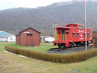
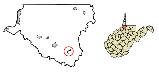
Cairo is a town in Ritchie County, West Virginia, United States, along West Virginia Route 31, the North Fork of the Hughes River, and the North Bend Rail Trail. The population was 174 at the 2020 census.

<span class="mw-page-title-main">Hinton, West Virginia</span> City in West Virginia, United States

Hinton is a city in and the county seat of Summers County, West Virginia, United States. The population was 2,266 at the 2020 census. Hinton was established in 1873 and chartered in 1897. Hinton was named after John "Jack" Hinton, the original owner of the town site. Much of Hinton's downtown was placed on the National Register of Historic Places in 1984. In 1994, part of Paramount's film Lassie was shot in Hinton. In the 1990s, Hinton's downtown experienced economic decline after a hospital moved away and Interstate 64 bypassed the town. In 2007, Hinton native and business owner Ken Allman founded MountainPlex Properties, which since then has worked to preserve and revitalize the Hinton Historic District.

<span class="mw-page-title-main">Davis, West Virginia</span> Town in West Virginia, United States

Davis is a town in Tucker County, West Virginia, United States, situated along the Blackwater River. The population was 595 at the 2020 census.

<span class="mw-page-title-main">Hambleton, West Virginia</span> Town in West Virginia, United States

Hambleton is a town in Tucker County, West Virginia, United States. The population was 216 at the 2020 census. Hambleton was established in 1889, but not incorporated until 1905. It was named by then United States Senator Stephen B. Elkins in honor of a stockholder by this name in the West Virginia Central Railroad Company. The town was previously known as Hulings.

<span class="mw-page-title-main">New Martinsville, West Virginia</span> City in West Virginia, United States

New Martinsville is a city in and the county seat of Wetzel County, West Virginia, United States, along the Ohio River. The population was 5,186 at the 2020 census.

<span class="mw-page-title-main">Smithfield, West Virginia</span> Town in West Virginia, United States

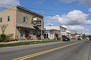
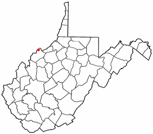
Smithfield is a town in Wetzel County, West Virginia, United States. The population was 103 at the 2020 census.

<span class="mw-page-title-main">Boaz, West Virginia</span> CDP in West Virginia, United States

Boaz is a census-designated place (CDP) in Wood County, West Virginia, United States. It is part of the Parkersburg-Marietta-Vienna, WV-OH Metropolitan Statistical Area. As of the 2020 census, the CDP population was 1,321.

References

  1. Elected officials. (n.d.). Retrieved February 12, 2021, from https://local.wv.gov/TerraAlta/Pages/ElectedOfficials.aspx
  2. "2019 U.S. Gazetteer Files". United States Census Bureau. Retrieved August 7, 2020.
  3. 1 2 U.S. Geological Survey Geographic Names Information System: Terra Alta, West Virginia
  4. 1 2 3 "City and Town Population Totals: 2020-2021". Census.gov. US Census Bureau. Retrieved July 3, 2022.
  5. 1 2 "U.S. Census website". United States Census Bureau . Retrieved January 31, 2008.
  6. "U.S. Census website". United States Census Bureau . Retrieved December 2, 2022.
  7. Kenny, Hamill (1945). West Virginia Place Names: Their Origin and Meaning, Including the Nomenclature of the Streams and Mountains. Piedmont, WV: The Place Name Press. p. 622.
  8. Capace, Nancy (1999). Encyclopedia of West Virginia. North American Book Dist LLC. p. 193. ISBN   978-0-403-09843-9.
  9. "National Register Information System". National Register of Historic Places . National Park Service. July 9, 2010.
  10. "US Gazetteer files: 2010, 2000, and 1990". United States Census Bureau. February 12, 2011. Retrieved April 23, 2011.
  11. "US Gazetteer files 2010". United States Census Bureau. Archived from the original on January 25, 2012. Retrieved January 24, 2013.
  12. Climate Summary for Terra Alta, West Virginia
  13. "NowData – NOAA Online Weather Data". National Oceanic and Atmospheric Administration. Retrieved June 13, 2021.
  14. "Station: Terra Alta #1, WV". U.S. Climate Normals 2020: U.S. Monthly Climate Normals (1991–2020). National Oceanic and Atmospheric Administration. Retrieved June 13, 2021.
  15. "Census of Population and Housing". Census.gov. Retrieved June 4, 2015.
  16. "U.S. Census website". United States Census Bureau . Retrieved January 24, 2013.