Westover, West Virginia

Last updated

Westover, West Virginia
Westover Bridge 2017a.jpg
Westover viewed from across the Monongahela River
Monongalia County West Virginia Incorporated and Unincorporated areas Westover Highlighted.svg
Location of Westover in Monongalia County, West Virginia.
Coordinates: 39°38′6″N79°58′28″W / 39.63500°N 79.97444°W / 39.63500; -79.97444
Country Flag of the United States.svg  United States
State Flag of West Virginia.svg  West Virginia
County Flag of Monongalia County, West Virginia.svg Monongalia
Area
[1]
  Total1.50 sq mi (3.90 km2)
  Land1.50 sq mi (3.89 km2)
  Water0.00 sq mi (0.00 km2)
Elevation
[2]
945 ft (288 m)
Population
 (2020) [3]
  Total3,955
  Estimate 
(2021) [3]
4,075
  Density2,776.45/sq mi (1,072.10/km2)
Time zone UTC-5 (Eastern (EST))
  Summer (DST) UTC-4 (EDT)
ZIP codes
26501-26502
Area code 304
FIPS code 54-85996 [4]
GNIS feature ID1555960 [2]
Website https://www.westoverwv.org

Westover is a city in Monongalia County, West Virginia, United States, along the Monongahela River. The population was 3,995 at the 2020 census. [5] It is part of the Morgantown metropolitan area.

Contents

History

Westover was named from its location over the river from Morgantown. [6] [7] Westover was incorporated on October 12, 1911. Westover expanded from its original area to include Riverside on November 27, 1945, Morgan Heights, Fairmor and Maple Grove on November 22, 1947; and the area in which Westover Park was built on March 10, 1955.

Geography

Westover is located at 39°38′6″N79°58′28″W / 39.63500°N 79.97444°W / 39.63500; -79.97444 (39.635095, -79.974382). [8]

According to the United States Census Bureau, the city has a total area of 1.51 square miles (3.91 km2), all land. [9]

Demographics

Historical population
CensusPop.Note
1920 721
1930 1,633126.5%
1940 1,7527.3%
1950 4,318146.5%
1960 4,74910.0%
1970 5,0867.1%
1980 4,884−4.0%
1990 4,201−14.0%
2000 3,941−6.2%
2010 3,9831.1%
2020 3,955−0.7%
2021 (est.)4,075 [3] 3.0%
U.S. Decennial Census [10]

2010 census

As of the census [11] of 2010, there were 3,983 people, 1,845 households, and 990 families living in the city. The population density was 2,637.7 inhabitants per square mile (1,018.4/km2). There were 2,016 housing units at an average density of 1,335.1 per square mile (515.5/km2). The racial makeup of the city was 91.2% White, 4.9% African American, 0.3% Native American, 1.1% Asian, 0.3% from other races, and 2.2% from two or more races. Hispanic or Latino of any race were 1.7% of the population.

There were 1,845 households, of which 22.6% had children under the age of 18 living with them, 36.0% were married couples living together, 12.6% had a female householder with no husband present, 5.0% had a male householder with no wife present, and 46.3% were non-families. 35.5% of all households were made up of individuals, and 11% had someone living alone who was 65 years of age or older. The average household size was 2.16 and the average family size was 2.79.

The median age in the city was 38 years. 17.8% of residents were under the age of 18; 11.6% were between the ages of 18 and 24; 28.5% were from 25 to 44; 26.8% were from 45 to 64; and 15.1% were 65 years of age or older. The gender makeup of the city was 50.1% male and 49.9% female.

2000 census

As of the census [4] of 2000, there were 3,941 people, 1,807 households, and 1,004 families living in the city. The population density was 2,995.5 people per square mile (1,152.7/km2). There were 1,983 housing units at an average density of 1,507.2 per square mile (580.0/km2). The racial makeup of the city was 93.58% White, 3.48% African American, 0.20% Native American, 0.74% Asian, 0.03% Pacific Islander, 0.25% from other races, and 1.73% from two or more races. Hispanic or Latino of any race were 0.46% of the population.

There were 1,807 households, out of which 23.6% had children under the age of 18 living with them, 40.6% were married couples living together, 11.9% had a female householder with no husband present, and 44.4% were non-families. 35.3% of all households were made up of individuals, and 12.2% had someone living alone who was 65 years of age or older. The average household size was 2.18 and the average family size was 2.86.

In the city, the population was spread out, with 19.9% under the age of 18, 11.1% from 18 to 24, 29.5% from 25 to 44, 22.1% from 45 to 64, and 17.4% who were 65 years of age or older. The median age was 38 years. For every 100 females, there were 88.3 males. For every 100 females age 18 and over, there were 84.0 males.

The median income for a household in the city was $28,659, and the median income for a family was $43,469. Males had a median income of $29,355 versus $21,672 for females. The per capita income for the city was $18,199. About 10.0% of families and 17.8% of the population were below the poverty line, including 26.3% of those under age 18 and 5.2% of those age 65 or over.

Education

Monongalia County Schools operates area schools. [12]

The zoned schools are Skyview Elementary School, [13] Westwood Middle School, [14] and University High School. [15]

Related Research Articles

<span class="mw-page-title-main">Monongalia County, West Virginia</span> County in West Virginia, United States

Monongalia County, known locally as Mon County, is located in the U.S. state of West Virginia. As of the 2020 census, the population was 105,822, making it West Virginia's third-most populous county. Its county seat is Morgantown. The county was founded in 1776. Monongalia County is included in the Morgantown, WV Metropolitan Statistical Area, and is the largest county in North-Central West Virginia. It is part of the Pittsburgh media market.

<span class="mw-page-title-main">Whiteriver, Arizona</span> Census designated place in Arizona, United States

Whiteriver is a census-designated place (CDP) located on the Fort Apache Indian Reservation in Navajo County, Arizona, United States. The population was 4,104 at the 2010 census, making it the largest settlement on the Reservation.

<span class="mw-page-title-main">Alexander, Arkansas</span> City in Arkansas, United States

Alexander is a city in Pulaski and Saline counties in the U.S. state of Arkansas. Located in Central Arkansas, the town was founded as a construction camp for the nearby railroad. Following its completion, the citizens decided to incorporate in 1887. Alexander is home to the Arkansas Juvenile Assessment and Treatment Center. The population was 2,901 at the 2010 census.

<span class="mw-page-title-main">Gillsville, Georgia</span> City in Georgia, United States

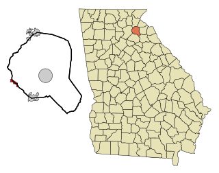
Gillsville is a city in Banks and Hall counties in the U.S. state of Georgia. The population was 235 at the 2010 census.

<span class="mw-page-title-main">Bennett, Iowa</span> City in Iowa, United States

Bennett is a city in Cedar County, Iowa, United States. The population was 347 at the 2020 census.

<span class="mw-page-title-main">Hill Township, Michigan</span> Civil township in Michigan, United States

Hill Township is a civil township of Ogemaw County in the U.S. state of Michigan. The population was 1,361 at the 2010 census.

<span class="mw-page-title-main">Willowick, Ohio</span> City in Ohio, United States

Willowick is a city in Lake County, Ohio, United States, on Lake Erie. The population was 14,204 at the 2020 census. A suburb of Cleveland, Willowick is served by a branch of the Willoughby-Eastlake Public Library. The city's name is a portmanteau of two adjacent cities, Willoughby and Wickliffe. As of 2022, the mayor of Willowick is Michael Vanni.

<span class="mw-page-title-main">Manorville, Pennsylvania</span> Borough in Pennsylvania, United States

Manorville is a borough in Armstrong County, Pennsylvania, United States. The population was 382 at the 2020 census.

<span class="mw-page-title-main">Fairview Township, Butler County, Pennsylvania</span> Township in Pennsylvania, United States

Fairview Township is a township in Butler County, Pennsylvania, United States. The population was 1,942 at the 2020 census.

<span class="mw-page-title-main">East Brandywine Township, Pennsylvania</span> Township in Pennsylvania, United States

East Brandywine Township is a township in Chester County, Pennsylvania, United States. The population was 9,746 at the 2020 census.

<span class="mw-page-title-main">Westover, Pennsylvania</span> Borough in Pennsylvania, United States

Westover is a borough in Clearfield County, Pennsylvania, United States. The population was 361 at the 2020 census.

<span class="mw-page-title-main">Burnham, Pennsylvania</span> Borough in Pennsylvania, United States

Burnham is a borough in Mifflin County, Pennsylvania, United States. The population was 1,999 at the 2020 census.

<span class="mw-page-title-main">McEwen, Tennessee</span> City in Tennessee, United States

McEwen is a city in Humphreys County, Tennessee, United States. The population was 1,750 at the 2010 census.

<span class="mw-page-title-main">Bayou Vista, Texas</span> City in Texas, United States

Bayou Vista is a city in Galveston County, Texas, United States. The population was 1,537 at the 2010 census. It received severe damage from Hurricane Ike on September 13, 2008.

<span class="mw-page-title-main">Blacksville, West Virginia</span> Town in West Virginia

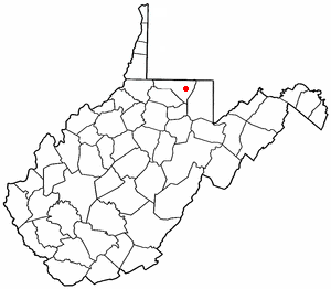
Blacksville is an Incorporated Town in Monongalia County, West Virginia, United States. The population was 118 at the 2020 census. It is included in the Morgantown, West Virginia Metropolitan Statistical Area.

<span class="mw-page-title-main">Brookhaven, West Virginia</span> CDP in West Virginia

Brookhaven is a census-designated place (CDP) in Monongalia County, West Virginia, United States. The population was 5,707 at the 2020 census. It is included in the Morgantown, West Virginia Metropolitan Statistical Area.

<span class="mw-page-title-main">Granville, West Virginia</span> Town in West Virginia

Granville is a town in Monongalia County, West Virginia, United States. The population was 1,355 at the 2020 census. It is included in the Morgantown metropolitan area.

<span class="mw-page-title-main">Star City, West Virginia</span> Town in West Virginia

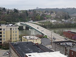
Star City is a town in Monongalia County, West Virginia, United States. The population was 1,779 at the 2020 census. It is included in the Morgantown, West Virginia Metropolitan Statistical Area.

<span class="mw-page-title-main">Rivergrove, Oregon</span> City in Oregon, United States

Rivergrove is a city in Clackamas County, Oregon, United States. A small portion of the city extends into nearby Washington County. Its name is a portmanteau of the Tualatin River, which forms its southern border, and Lake Grove, a community that is now part of Lake Oswego. Interstate 5 forms the western border, with Childs Road serving as the northern border for much of the city. The population was 545 at the 2020 census.

<span class="mw-page-title-main">Delafield (town), Wisconsin</span> Town in Wisconsin, United States

The Town of Delafield is located in Waukesha County, Wisconsin, United States. The population was 8,095 at the 2020 census. The City of Delafield is adjacent to the town. The unincorporated community of Buena Vista is located in the town.

References

  1. "2019 U.S. Gazetteer Files". United States Census Bureau. Retrieved August 7, 2020.
  2. 1 2 U.S. Geological Survey Geographic Names Information System: Westover, West Virginia
  3. 1 2 3 "City and Town Population Totals: 2020-2021". Census.gov. US Census Bureau. Retrieved July 3, 2022.
  4. 1 2 "U.S. Census website". United States Census Bureau . Retrieved January 31, 2008.
  5. "U.S. Census website". United States Census Bureau . Retrieved December 2, 2022.
  6. Capace, Nancy (1999). Encyclopedia of West Virginia. North American Book Dist LLC. p. 198. ISBN   978-0-403-09843-9.
  7. Kenny, Hamill (1945). West Virginia Place Names: Their Origin and Meaning, Including the Nomenclature of the Streams and Mountains. Piedmont, WV: The Place Name Press. p. 669.
  8. "US Gazetteer files: 2010, 2000, and 1990". United States Census Bureau. February 12, 2011. Retrieved April 23, 2011.
  9. "US Gazetteer files 2010". United States Census Bureau . Retrieved January 24, 2013.
  10. "Census of Population and Housing". Census.gov. Retrieved June 4, 2015.
  11. "U.S. Census website". United States Census Bureau . Retrieved January 24, 2013.
  12. "2010 CENSUS - CENSUS BLOCK MAP: Westover city, WV." U.S. Census Bureau. Retrieved on November 16, 2018.
  13. "Skyview ES Zone" and "Westover ES Zone" - Derived from the Monongalia County School District Mapping program. Monongalia County Schools. Retrieved on November 16, 2018.
  14. "Westwood MS Zone." and "Westover MS Zone" - Derived from the Monongalia County School District Mapping program. Monongalia County Schools. Retrieved on November 16, 2018.
  15. "University HS Zone" and "Westover HS Zone" - Derived from the Monongalia County School District Mapping program. Monongalia County Schools. Retrieved on November 16, 2018.