Pax, West Virginia | |
---|---|
Coordinates: 37°54′40″N81°15′55″W / 37.91111°N 81.26528°W | |
Country | United States |
State | West Virginia |
County | Fayette |
Area | |
• Total | 0.30 sq mi (0.78 km2) |
• Land | 0.30 sq mi (0.78 km2) |
• Water | 0.00 sq mi (0.00 km2) |
Elevation | 1,644 ft (501 m) |
Population | |
• Total | 167 |
• Estimate (2019) [3] | 152 |
• Density | 506.67/sq mi (195.68/km2) |
Time zone | UTC-5 (Eastern (EST)) |
• Summer (DST) | UTC-4 (EDT) |
ZIP code | 25904 |
Area code | 304 |
FIPS code | 54-62356 [4] |
GNIS feature ID | 1555318 [5] |
Website | local |
Pax is a town in Fayette County, West Virginia, United States. The current mayor of Pax is William F. Hughes. [6] The population was 167 at the 2010 census.
The community most likely derives its name from nearby Packs Branch creek. [7]
According to the United States Census Bureau, the town has a total area of 0.30 square miles (0.78 km2), all land. [8]
Census | Pop. | Note | %± |
---|---|---|---|
1930 | 608 | — | |
1940 | 631 | 3.8% | |
1950 | 561 | −11.1% | |
1960 | 408 | −27.3% | |
1970 | 288 | −29.4% | |
1980 | 274 | −4.9% | |
1990 | 167 | −39.1% | |
2000 | 174 | 4.2% | |
2010 | 167 | −4.0% | |
2019 (est.) | 152 | [3] | −9.0% |
U.S. Decennial Census [9] |
At the 2010 census there were 167 people, 78 households, and 45 families living in the town. The population density was 556.7 inhabitants per square mile (214.9/km2). There were 102 housing units at an average density of 340.0 per square mile (131.3/km2). The racial makeup of the town was 100.0% White. Hispanic or Latino of any race were 1.2%. [2]
Of the 78 households 25.6% had children under the age of 18 living with them, 38.5% were married couples living together, 12.8% had a female householder with no husband present, 6.4% had a male householder with no wife present, and 42.3% were non-families. 34.6% of households were one person and 17.9% were one person aged 65 or older. The average household size was 2.14 and the average family size was 2.73.
The median age in the town was 41.8 years. 18.6% of residents were under the age of 18; 11.4% were between the ages of 18 and 24; 25.2% were from 25 to 44; 25.2% were from 45 to 64; and 19.8% were 65 or older. The gender makeup of the town was 49.7% male and 50.3% female.
At the 2000 census there were 199 people, 81 households, and 49 families living in the town. The population density was 551.5 inhabitants per square mile (209.9/km2). There were 97 housing units at an average density of 307.5 per square mile (117.0/km2). The racial makeup of the town was 97.70% White, 1.15% African American, and 1.15% from two or more races. [4] Of the 78 households 25.6% had children under the age of 18 living with them, 46.2% were married couples living together, 12.8% had a female householder with no husband present, and 35.9% were non-families. 34.6% of households were one person and 23.1% were one person aged 65 or older. The average household size was 2.23 and the average family size was 2.86.
The age distribution was 24.1% under the age of 18, 5.7% from 18 to 24, 24.7% from 25 to 44, 25.3% from 45 to 64, and 20.1% 65 or older. The median age was 42 years. For every 100 females, there were 93.3 males. For every 100 females age 18 and over, there were 88.6 males.
The median household income was $21,875 and the median family income was $27,500. Males had a median income of $31,250 versus $18,750 for females. The per capita income for the town was $12,746. About 4.3% of families and 9.7% of the population were below the poverty line, including 5.6% of those under the age of eighteen and 16.7% of those sixty five or over.
Dunreith is a town in Spiceland Township, Henry County, Indiana, United States. The population was 177 at the 2010 census.
Caswell is a town in Aroostook County, Maine, United States. The population was 293 at the 2020 census.
Chapman is a town in Aroostook County, Maine, United States. The population was 491 at the 2020 census.
Oakfield is a town in Aroostook County, Maine, United States. The population was 661 at the 2020 census. The village of Oakfield, listed as a census-designated place, is in the northwestern corner of the town.
Portage Lake is a town in Aroostook County, Maine, United States. The population was 359 at the 2020 census.
Stoneham is a town in Oxford County, Maine, United States. The population was 261 at the 2020 census.
Woodville is a town in Penobscot County, Maine, United States. The population was 201 at the 2020 census.
Ripley is a town in Somerset County, Maine, United States. The community was named after Brigadier General Eleazer Wheelock Ripley of the War of 1812. The population was 484 at the 2020 census.
Alexander is a town in Washington County, Maine, United States. The population was 525 at the 2020 census. The town is named for Alexander Baring, 1st Baron Ashburton, the British negotiator of the Webster–Ashburton Treaty which ended the Aroostook War in 1838–1839.
Crawford is a town in Washington County, Maine, United States. The town was named after William H. Crawford, Secretary of the Treasury. The population was 93 at the 2020 census.
Galestown is a town in Dorchester County, Maryland, United States. The population was 138 at the 2010 census.
Lewis and Clark Village is a village in Buchanan County, Missouri, United States. The population was 96 at the 2020 census. It is part of the St. Joseph, MO–KS Metropolitan Statistical Area.
Hayward is a census-designated place and former village in Pemiscot County, Missouri, United States. The population was 131 at the 2010 census.
Esmond is a city in Benson County, North Dakota, United States. The population was 91 at the 2020 census. Esmond was founded in 1901.
North River is a city in Cass County, North Dakota, United States. The population was 55 at the 2020 census. North River was founded in 1973. It is a suburb/bedroom community directly adjacent to the city of Fargo.
Addyston is a village in Miami Township, Hamilton County, Ohio, United States. Located along the Ohio River, it is a western suburb of the neighboring city of Cincinnati. The population was 927 at the 2020 census.
Sylvester is a town in Boone County, West Virginia, United States, along the Big Coal River. The population was 166 at the 2020 census. Sylvester was incorporated on April 11, 1952, by the Boone County Circuit Court. Sylvester bears the name of a family of settlers.
Pratt is a town in Kanawha County, West Virginia, United States, along the Kanawha River. The population was 482 at the 2020 census.
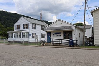
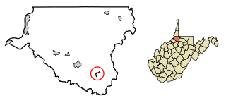
Durbin is a town in Pocahontas County, West Virginia, United States. The population was 235 at the 2020 census.
Smithfield is a town in Wetzel County, West Virginia, United States. The population was 103 at the 2020 census.