Kenova, West Virginia

Last updated

Kenova, West Virginia
Joseph S. Miller House at Kenova.jpg
Flag of Kenova, West Virginia.svg
Seal of Kenova, West Virginia.svg
Logo of Kenova, West Virginia.svg
Nickname: 
Western Gate of the Mountain State
Wayne County West Virginia Incorporated and Unincorporated areas Kenova Highlighted.svg
Location of Kenova in Wayne County, West Virginia.
Coordinates: 38°23′59″N82°34′43″W / 38.39972°N 82.57861°W / 38.39972; -82.57861
Country United States
State West Virginia
County Wayne
Government
  Type Mayor–council
  MayorTimothy Bias [1]
  Council presidentKent Keyser
Area
[2]
  Total1.66 sq mi (4.30 km2)
  Land1.32 sq mi (3.42 km2)
  Water0.34 sq mi (0.88 km2)
Elevation
558 ft (170 m)
Population
 (2020) [3]
  Total3,030
  Estimate 
(2021) [3]
2,978
  Density2,244.88/sq mi (866.71/km2)
Time zone UTC-5 (Eastern (EST))
  Summer (DST) UTC-4 (EDT)
ZIP code
25530
Area code 304
FIPS code 54-43180 [4]
GNIS feature ID1541155 [5]
Website https://kenovawv.com/

Kenova is a city in Wayne County, West Virginia, United States, situated at the confluence of the Ohio and Big Sandy rivers. The city's name is a portmanteau of Kentucky, Ohio, and Virginia (Va), owing to its location where the three states met before the creation of West Virginia. [6] The population was 3,030 at the 2020 census. [3] It is part of the Huntington–Ashland metropolitan area. [7]

Contents

Founded in 1859 but not incorporated until 1894, the town's early history and development was centered on the railroad industry. It is home to a major Norfolk Southern Ohio River Bridge. CSX Transportation's former Chesapeake and Ohio Kanawha Subdivision travels through the town as well. The city is also near the site of the Southern Airways Flight 932 aviation disaster. In 1970, a plane carrying the Marshall University football team crashed on a hillside on approach to the Tri-State Airport, killing all on board. A movie about the tragedy, We Are Marshall , was released in 2006.

Geography

A sign welcoming motorists to Kenova along U.S. Route 60. KenovaWV sign.jpg
A sign welcoming motorists to Kenova along U.S. Route 60.
The Norfolk Southern Bridge as seen from Kenova KenovaRRBridge.jpg
The Norfolk Southern Bridge as seen from Kenova

According to the United States Census Bureau, the city has a total area of 1.60 square miles (4.14 km2), of which 1.26 square miles (3.26 km2) is land and 0.34 square miles (0.88 km2) is water. [8]

Demographics

Historical population
CensusPop.Note
1900 863
1910 99214.9%
1920 2,162117.9%
1930 3,68070.2%
1940 3,9026.0%
1950 4,32010.7%
1960 4,5775.9%
1970 4,8606.2%
1980 4,454−8.4%
1990 3,748−15.9%
2000 3,485−7.0%
2010 3,216−7.7%
2020 3,030−5.8%
2021 (est.)2,978 [3] −1.7%
Source: [9]

2010 census

As of the census [10] of 2010, there were 3,216 people, 1,441 households, and 868 families living in the city. The population density was 2,552.4 inhabitants per square mile (985.5/km2). There were 1,645 housing units at an average density of 1,305.6 per square mile (504.1/km2). The racial makeup of the city was 98.8% White, 0.2% African American, 0.3% Native American, 0.1% Asian, 0.1% from other races, and 0.7% from two or more races. Hispanic or Latino of any race were 1.0% of the population.

There were 1,441 households, of which 29.3% had children under the age of 18 living with them, 38.0% were married couples living together, 16.7% had a female householder with no husband present, 5.6% had a male householder with no wife present, and 39.8% were non-families. 35.6% of all households were made up of individuals, and 16.3% had someone living alone who was 65 years of age or older. The average household size was 2.22 and the average family size was 2.84.

The median age in the city was 40.6 years. 22.1% of residents were under the age of 18; 8% were between the ages of 18 and 24; 24.8% were from 25 to 44; 26.6% were from 45 to 64, and 18.6% were 65 years of age or older. The gender makeup of the city was 45.8% male and 54.2% female.

2000 census

As of the census [4] of 2000, there were 3,485 people, 1,594 households, and 996 families living in the city. The population density was 2,887.9 people per square mile (1,112.0/km2). There were 1,767 housing units at an average density of 1,464.3 per square mile (563.8/km2). The racial makeup of the city was 99.23% White, 0.23% African American, 0.17% Native American, 0.06% Asian, 0.03% from other races, and 0.29% from two or more races. Hispanic or Latino of any race were 0.20% of the population.

There were 1,594 households, out of which 24.5% had children under the age of 18 living with them, 43.3% were married couples living together, 14.9% had a female householder with no husband present, and 37.5% were non-families. 34.8% of all households were made up of individuals, and 15.9% had someone living alone who was 65 years of age or older. The average household size was 2.18 and the average family size was 2.77.

In the city, the population was spread out, with 20.5% under the age of 18, 9.0% from 18 to 24, 25.7% from 25 to 44, 24.6% from 45 to 64, and 20.1% who were 65 years of age or older. The median age was 41 years. For every 100 females, there were 83.7 males. For every 100 females age 18 and over, there were 81.0 males.

The median income for a household in the city was $23,342, and the median income for a family was $29,688. Males had a median income of $27,656 versus $22,500 for females. The per capita income for the city was $16,485. About 14.5% of families and 18.6% of the population were below the poverty line, including 26.4% of those under age 18 and 12.6% of those age 65 or over.

Arts and culture

Dreamland Pool, first opened in 1926, was once the largest swimming pool in the United States east of the Mississippi River, measuring 250 feet (76 m) by 125 feet (38 m). The original construction included a three-story pavilion that ran the length of the pool. The top floor of the pavilion included a dance floor, where many notable Big Bands played though the 1930s and 1940s and attracted big names such as Benny Goodman, Louis Armstrong, and Frank Sinatra. [11] A fire in 1972 destroyed the pavilion, but the rest of the facility survived. The pool was conveyed to the City of Kenova in 1973. Presently, the Kenova Parks & Recreation Board oversees the operation and management of the facility. About the size of a football field, Dreamland sports two cement floats equidistant from each other in the middle of the pool to allow swimmers a place to rest. Dreamland Pool was recently renovated in 2015.

The 1891 Victorian Joseph S. Miller House is listed on the National Register of Historic Places and was once visited by President Grover Cleveland. In recent years it has become known as The Pumpkin House, because of the more than 3000 hand-carved Jack-o-Lanterns which owner Ric Griffith, the town's previous mayor and current pharmacist, adorn it with each Halloween season. The Pumpkin House has received national media attention and has been featured on segments of NBC's The Today Show, The Ellen DeGeneres Show, and many other media outlets. Pumpkin house owner Ric Griffith is also a longtime owner of the Griffith and Feil Drug Store, an old-time drug store with an authentic early 20th-century soda fountain that he has totally restored. His father, the longtime Kenova businessman and resident Dick Griffith worked in the pharmacy on a semi-retirement basis for many years until he was in his early 90s. He also sponsored a tennis tournament that bears his name in nearby Huntington.

Education

Since the closing of Ceredo-Kenova and Buffalo-Wayne High Schools in 1998, Kenova Elementary is the lone public education facility within Kenova city limits. The school has been awarded multiple national blue ribbons in academic achievement. Buffalo Elementary and Buffalo Middle schools are also located near Kenova, but just outside city limits. The former Ceredo-Kenova High School, locally known as "C-K," boasted a great number of athletic state championships, including 12 in football, two in basketball, one in cheerleading, and in 1995 won their only WV State Class A Region 4 Baseball championship. Buffalo can credit championships in boys' and girls' basketball and in football to their accomplishments. In 1998, Ceredo-Kenova and Buffalo-Wayne High Schools were closed and consolidated with Huntington-based Vinson High School to form Spring Valley High School. The former Vinson High School is now known as Vinson Middle School. In 2015 the former Ceredo-Kenova High School was demolished, and the former Buffalo-Wayne High School was razed in September 2019. [12]

Notable people

See also

Related Research Articles

<span class="mw-page-title-main">Wayne County, West Virginia</span> County in West Virginia, United States

Wayne County is the westernmost county in the U.S. state of West Virginia. As of the 2020 census, the population was 38,982. Its county seat is Wayne. The county was founded in 1842 and named for General "Mad" Anthony Wayne.

<span class="mw-page-title-main">Truro, Iowa</span> City in Iowa, United States

Truro is a city in southeast Madison County, Iowa, United States. The population was 509 at the time of the 2020 census. Truro is part of the Des Moines–West Des Moines Metropolitan Statistical Area.

<span class="mw-page-title-main">Buffalo, Iowa</span> Town in Iowa, United States

Buffalo is a town in Scott County, Iowa, United States. The population was 1,176 at the 2020 census. Buffalo is located on the Mississippi River. The town is a part of the Quad Cities Metropolitan Area.

<span class="mw-page-title-main">Buffalo, Minnesota</span> City in Minnesota, United States

Buffalo is a city in the U.S. state of Minnesota and the county seat of Wright County. It is in the Minneapolis–Saint Paul metropolitan area, about 42 miles northwest of Minneapolis on Buffalo Lake. Buffalo's population was 15,453 at the 2010 census and 18,168 at the 2020 census.

<span class="mw-page-title-main">Waynesboro, Mississippi</span> City in Mississippi, United States

Waynesboro is a city in Wayne County, Mississippi, United States. The population was 5,043 at the 2010 census. It is the county seat of Wayne County.

<span class="mw-page-title-main">West Union, Ohio</span> Village in Ohio, United States

West Union is a village in Adams County, Ohio, United States, about 55 miles (89 km) southeast of Cincinnati. The population was 3,004 at the 2020 census. It is the county seat of Adams County. West Union is served by West Union High School, the Adams County/Ohio Valley School District, and the West Union Public Library, a branch of the Adams County Public Library.

<span class="mw-page-title-main">Lyons, Ohio</span> Village in Ohio, United States

Lyons is a village in Fulton County, Ohio, United States. The population was 602 at the 2020 census.

<span class="mw-page-title-main">Byesville, Ohio</span> Village in Ohio, United States

Byesville is a village in Guernsey County, Ohio, United States, along Wills Creek. The population was 2,364 at the 2020 census.

<span class="mw-page-title-main">Deer Park, Ohio</span> City in Ohio, United States

Deer Park is a city in Hamilton County, Ohio, United States. It is a suburb of Cincinnati. The population was 5,432 at the 2020 census.

<span class="mw-page-title-main">Sinking Spring, Ohio</span> Village in Ohio, United States

Sinking Spring is a village in Highland County, Ohio, United States. The population was 118 at the 2020 census.

<span class="mw-page-title-main">Willoughby Hills, Ohio</span> City in Ohio, United States

Willoughby Hills is a city in Lake County, Ohio, United States, along the Chagrin River. The population was 10,019 at the 2020 census. A suburb of Cleveland, it is part of the Cleveland metropolitan area.

<span class="mw-page-title-main">South Point, Ohio</span> Village in Ohio, United States

South Point is a village in Lawrence County, Ohio, United States, along the Ohio River. The population was 3,836 at the 2020 census. It is part of the Huntington–Ashland metropolitan area.

<span class="mw-page-title-main">Germantown, Ohio</span> City in Ohio, United States

Germantown is a city in Montgomery County, Ohio, United States. The population was 5,796 at the 2020 census. A part of the Dayton metropolitan area, Germantown was founded by German Americans from Pennsylvania and was once home to a cigar industry.

<span class="mw-page-title-main">Riverside, Ohio</span> City in Ohio, United States

Riverside is a city in Montgomery County, Ohio, United States. The population was 24,474 at the 2020 census. A suburb of Dayton, it is part of the Dayton metropolitan area.

<span class="mw-page-title-main">Kalida, Ohio</span> Village in Ohio, United States

Kalida is a village in Putnam County, Ohio, United States. The population was 1,455 at the 2020 census.

<span class="mw-page-title-main">Limaville, Ohio</span> Census-designated place in Ohio, United States

Limaville is a census-designated place (CDP) and former village in Stark County, Ohio, United States. The population was 151 at the 2020 census. It is part of the Canton–Massillon Metropolitan Statistical Area.

<span class="mw-page-title-main">St. Marys, West Virginia</span> City in West Virginia, United States

St. Marys is a city and the county seat of Pleasants County, West Virginia, United States. The population was 1,847 at the 2020 census. It is part of the Parkersburg–Vienna metropolitan area. St. Marys was established in 1849 by Alexander Creel, who is said to have had a vision of Mary while passing the townsite by boat on the Ohio River.

<span class="mw-page-title-main">Ceredo, West Virginia</span> Town in West Virginia, United States

Ceredo is a town in Wayne County, West Virginia, United States, situated along the Ohio River. The population was 1,408 at the 2020 census. Ceredo is a part of the Huntington-Ashland, WV-KY-OH Metropolitan Statistical Area (MSA). As of the 2000 census, the MSA had a population of 288,649.

<span class="mw-page-title-main">Wayne, West Virginia</span> Town in West Virginia, United States

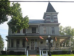
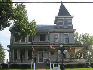
Wayne is a town in and the county seat of Wayne County, West Virginia, United States. The population was 1,441 at the 2020 census. It is part of the Huntington–Ashland metropolitan area.

<span class="mw-page-title-main">Sharonville, Ohio</span> City in Ohio, United States

Sharonville is a city largely in Hamilton County in the U.S. state of Ohio. The population was 14,117 at the 2020 census.

References

  1. https://kenovawv.com/ [ bare URL ]
  2. "2019 U.S. Gazetteer Files". United States Census Bureau. Retrieved August 7, 2020.
  3. 1 2 3 4 "City and Town Population Totals: 2020-2021". Census.gov. US Census Bureau. Retrieved July 3, 2022.
  4. 1 2 "U.S. Census website". United States Census Bureau . Retrieved January 31, 2008.
  5. "US Board on Geographic Names". United States Geological Survey. October 25, 2007. Retrieved January 31, 2008.
  6. Remington, Frank L. (September 8, 1969). "Take a Good Look at the US Map. Towns Have the Craziest Names". The Milwaukee Journal. p. 2. Retrieved May 18, 2015.
  7. "Population statistics" (PDF). Archived from the original (PDF) on March 19, 2013.
  8. "US Gazetteer files 2010". United States Census Bureau. Archived from the original on July 2, 2012. Retrieved January 24, 2013.
  9. "Census of Population and Housing". U.S. Census Bureau. Retrieved June 3, 2015.
  10. "U.S. Census website". United States Census Bureau . Retrieved January 24, 2013.
  11. WSAZ news. "Dreamland Pool Opens Saturday". Archived from the original on August 29, 2008. Retrieved July 3, 2008. One local pool in our region is now on the road to a comeback after nearly closing.
  12. "News". March 6, 2024.[ dead link ]
  13. "Intuit®: Company Executive Leadership".