Ripley, West Virginia

Last updated

Ripley, West Virginia
Ripley West Virginia.jpg
North Court Street in downtown Ripley in 2007
Flag of Ripley, West Virginia.svg
Jackson County West Virginia Incorporated and Unincorporated areas Ripley Highlighted.svg
Location of Ripley in Jackson County, West Virginia.
Coordinates: 38°49′16″N81°42′51″W / 38.82111°N 81.71417°W / 38.82111; -81.71417
Country Flag of the United States.svg  United States
State Flag of West Virginia.svg  West Virginia
County Jackson
Government
  TypeCity Council/Mayor
  MayorCarolyn L. Rader
Area
[1]
  Total3.29 sq mi (8.51 km2)
  Land3.18 sq mi (8.23 km2)
  Water0.11 sq mi (0.28 km2)
Elevation
614 ft (187 m)
Population
 (2020) [2]
  Total3,074
  Estimate 
(2021) [2]
3,064
  Density994.33/sq mi (383.96/km2)
Time zone UTC-5 (Eastern (EST))
  Summer (DST) UTC-4 (EDT)
ZIP code
25271
Area code 304
FIPS code 54-68596 [3]
GNIS feature ID1545757 [4]
Website Official website

Ripley is a city in and the county seat of Jackson County, West Virginia, United States. [5] The population was 3,074 at the 2020 census. [2]

Contents

History

Jackson County Courthouse in 2012 JacksonCountyWVCourthouse.jpg
Jackson County Courthouse in 2012

Ripley was originally owned and settled by William, John, and Lewis Rodgers. They received a grant of 400 acres (1.6 km2) in 1768 where "Sycamore Creek joins Big Mill Creek" (the current site of Ripley). The land was later sold to Jacob (and Ann) Starcher, most probably in 1803. Jacob Starcher erected a grist mill in 1824 and laid out the town in 1830, naming it in honor of Harry Ripley, a young minister who was to be married, but drowned in Big Mill Creek, about one and a half miles north of the town, shortly before the ceremony took place. [6]

When Jackson County was formed in 1831, the residents of the county could not decide where to locate the county seat. The people who lived along the Ohio River near the Ravenswood settlement favored that location. The people who lived farther inland objected. The Virginia General Assembly appointed an independent commission to make the final decision which selected Ripley. In 1832, the Starchers donated 8 acres (32,000 m2) of land to the county, 2 acres (8,100 m2) for the location of the county courthouse and jail, and six for the general use of the new county (a public school and a cemetery were later located on the land). The town was chartered by the Virginia General Assembly in 1832. [6]

The post office was established in 1832 with the name Jackson Court House. The name was shortened in 1893 to Jackson. In 1897, the name became Ripley. [7]

During the American Civil War, Ripley remained under the control of the Union except for a brief incursion by the Confederate General Albert G. Jenkins in September 1862.

The last public hanging in West Virginia took place in Ripley in 1897, when John Morgan was hanged for murder. The spectacle prompted the West Virginia Legislature to ban public executions soon after. [8]

Geography

Ripley is located at 38°49′16″N81°42′51″W / 38.82111°N 81.71417°W / 38.82111; -81.71417 (38.821078, -81.714264), [9] along Mill Creek. [10]

According to the United States Census Bureau, the city has a total area of 3.28 square miles (8.50 km2), of which 3.17 square miles (8.21 km2) is land and 0.11 square miles (0.28 km2) is water. [11]

Climate

Climate data for Ripley, West Virginia (1991–2020 normals, extremes 1941–present)
MonthJanFebMarAprMayJunJulAugSepOctNovDecYear
Record high °F (°C)80
(27)
81
(27)
89
(32)
95
(35)
97
(36)
102
(39)
107
(42)
103
(39)
102
(39)
95
(35)
86
(30)
82
(28)
107
(42)
Mean maximum °F (°C)66.9
(19.4)
70.0
(21.1)
77.8
(25.4)
85.4
(29.7)
88.8
(31.6)
91.6
(33.1)
94.0
(34.4)
92.9
(33.8)
91.0
(32.8)
83.9
(28.8)
76.7
(24.8)
67.8
(19.9)
94.9
(34.9)
Mean daily maximum °F (°C)43.7
(6.5)
47.8
(8.8)
57.1
(13.9)
69.8
(21.0)
77.8
(25.4)
84.7
(29.3)
88.3
(31.3)
87.2
(30.7)
81.6
(27.6)
70.2
(21.2)
58.1
(14.5)
47.8
(8.8)
67.8
(19.9)
Daily mean °F (°C)32.8
(0.4)
35.8
(2.1)
43.7
(6.5)
54.7
(12.6)
63.9
(17.7)
71.7
(22.1)
75.8
(24.3)
74.3
(23.5)
68.1
(20.1)
56.1
(13.4)
45.1
(7.3)
37.2
(2.9)
54.9
(12.7)
Mean daily minimum °F (°C)21.8
(−5.7)
23.8
(−4.6)
30.3
(−0.9)
39.6
(4.2)
50.0
(10.0)
58.7
(14.8)
63.3
(17.4)
61.5
(16.4)
54.5
(12.5)
42.0
(5.6)
32.1
(0.1)
26.5
(−3.1)
42.0
(5.6)
Mean minimum °F (°C)2.9
(−16.2)
6.7
(−14.1)
15.1
(−9.4)
26.0
(−3.3)
35.4
(1.9)
47.4
(8.6)
54.7
(12.6)
52.6
(11.4)
42.7
(5.9)
29.5
(−1.4)
18.9
(−7.3)
11.8
(−11.2)
−0.7
(−18.2)
Record low °F (°C)−28
(−33)
−17
(−27)
−11
(−24)
11
(−12)
23
(−5)
35
(2)
39
(4)
35
(2)
27
(−3)
14
(−10)
0
(−18)
−17
(−27)
−28
(−33)
Average precipitation inches (mm)3.14
(80)
3.26
(83)
4.23
(107)
3.77
(96)
4.44
(113)
4.95
(126)
4.88
(124)
3.85
(98)
3.75
(95)
3.12
(79)
2.99
(76)
3.66
(93)
46.04
(1,169)
Average snowfall inches (cm)6.3
(16)
1.4
(3.6)
1.4
(3.6)
0.0
(0.0)
0.0
(0.0)
0.0
(0.0)
0.0
(0.0)
0.0
(0.0)
0.0
(0.0)
0.0
(0.0)
0.2
(0.51)
2.3
(5.8)
11.6
(29)
Average precipitation days (≥ 0.01 in)12.911.713.413.013.312.011.310.28.79.310.313.3139.4
Average snowy days (≥ 0.1 in)2.71.70.70.00.00.00.00.00.00.00.11.66.8
Source: NOAA [12] [13]

Demographics

Historical population
CensusPop.Note
1870 226
1880 42588.1%
1890 417−1.9%
1900 57938.8%
1910 5912.1%
1920 580−1.9%
1930 66915.3%
1940 75913.5%
1950 1,813138.9%
1960 2,75652.0%
1970 3,24417.7%
1980 3,4646.8%
1990 3,023−12.7%
2000 3,2637.9%
2010 3,252−0.3%
2020 3,074−5.5%
2021 (est.)3,064 [2] −0.3%
U.S. Decennial Census [14]

2010 census

At the 2010 census, [15] there were 3,252 people, 1,476 households and 854 families living in the city. The population density was 1,025.9 per square mile (396.1/km2). There were 1,614 housing units at an average density of 509.1 per square mile (196.6/km2). The racial makeup of the city was 98.2% White, 0.2% African American, 0.4% Asian, 0.3% from other races, and 0.9% from two or more races. Hispanic or Latino of any race were 0.5% of the population.

There were 1,476 households, of which 24.7% had children under the age of 18 living with them, 42.8% were married couples living together, 11.8% had a female householder with no husband present, 3.3% had a male householder with no wife present, and 42.1% were non-families. 39.2% of all households were made up of individuals, and 19.2% had someone living alone who was 65 years of age or older. The average household size was 2.12 and the average family size was 2.81.

The median age was 46.1 years. 19.7% of residents were under the age of 18; 7.4% were between the ages of 18 and 24; 21.7% were from 25 to 44; 26.2% were from 45 to 64; and 25% were 65 years of age or older. The gender makeup of the city was 44.6% male and 55.4% female.

2000 census

At the 2000 census, [3] there were 3,263 people, 1,423 households and 893 families living in the city. The population density was 1,056.3 per square mile (407.7/km2). There were 1,543 housing units at an average density of 499.5 per square mile (192.8/km2). The racial makeup of the city was 98.22% White, 0.06% African American, 0.06% Native American, 0.21% Asian, 0.37% from other races, and 1.07% from two or more races. Hispanic or Latino of any race were 0.64% of the population.

There were 1,423 households, of which 23.9% had children under the age of 18 living with them, 49.5% were married couples living together, 11.1% had a female householder with no husband present, and 37.2% were non-families. 34.4% of all households were made up of individuals, and 18.3% had someone living alone who was 65 years of age or older. The average household size was 2.17 and the average family size was 2.78.

19.2% of the population were under the age of 18, 8.3% from 18 to 24, 22.6% from 25 to 44, 24.0% from 45 to 64, and 25.8% who were 65 years of age or older. The median age was 45 years. For every 100 females, there were 79.8 males. For every 100 females age 18 and over, there were 73.4 males.

The median household income was $25,861 and the median income for a family was $37,027. Males had a median income of $29,531 and females $20,881. The per capita income was $15,451. About 12.1% of families and 16.4% of the population were below the poverty line, including 21.5% of those under age 18 and 9.9% of those age 65 or over.

Culture

Ripley claims to host the "Biggest Small Town Fourth of July Celebration" in the United States. [16] On 4 July 2002, then President George W. Bush gave a public speech at the town's courthouse. [17]

Education

Ripley is served by the Jackson County School District. Schools located in Ripley are:

Media

Radio

Notable people

Related Research Articles

<span class="mw-page-title-main">Tallapoosa County, Alabama</span> County in Alabama, United States

Tallapoosa County is located in the east-central portion of the U.S. state of Alabama. As of the 2020 census, the population was 41,311. Its county seat is Dadeville. Its largest city is Alexander City.

<span class="mw-page-title-main">Wyoming County, West Virginia</span> County in West Virginia, United States

Wyoming County is a county in the U.S. state of West Virginia. As of the 2020 census, the population was 21,382. Its county seat is Pineville. The county was created in 1850 from Logan County and named for the Lenape word meaning "large plains".

<span class="mw-page-title-main">Wood County, West Virginia</span> County in West Virginia, United States

Wood County is a county in the U.S. state of West Virginia. As of the 2020 census, the population was 84,296, making it West Virginia's fifth-most populous county. Its county seat is Parkersburg. The county was formed in 1798 from the western part of Harrison County and named for James Wood, governor of Virginia from 1796 to 1799.

<span class="mw-page-title-main">Wirt County, West Virginia</span> County in West Virginia, United States

Wirt County is a county in the U.S. state of West Virginia. As of the 2020 census, the population was 5,194, making it the least populous county in West Virginia. Its county seat is Elizabeth. The county was created in 1848 by the Virginia General Assembly and named for U.S. Attorney General and presidential candidate William Wirt. The county is served by one high school, Wirt County High School.

<span class="mw-page-title-main">Roane County, West Virginia</span> County in West Virginia, United States

Roane County is a county located in the U.S. state of West Virginia. As of the 2020 census, the population was 14,028. Its county seat is Spencer. The county was founded in 1856 and is named for Spencer Roane.

<span class="mw-page-title-main">Lincoln County, West Virginia</span> County in West Virginia, United States

Lincoln County is a county in the U.S. state of West Virginia. As of the 2020 census, the population was 20,463. Its county seat is Hamlin. The county was created in 1867 and named for Abraham Lincoln.

<span class="mw-page-title-main">Lewis County, West Virginia</span> County in West Virginia, United States

Lewis County is a county in the U.S. state of West Virginia. As of the 2020 census, the population was 17,033. Its county seat is Weston. The county was formed in 1816 from Harrison County.

<span class="mw-page-title-main">Jackson County, West Virginia</span> County in West Virginia, United States

Jackson County is a county in the U.S. state of West Virginia. As of the 2020 census, the population was 27,791. Its county seat is Ripley, and its largest municipality is Ravenswood.

<span class="mw-page-title-main">Argenta, Illinois</span> Village in Illinois, United States

Argenta is a village in Macon County, Illinois, United States, whose population was 913 at the 2020 census. It is included in the Decatur, Illinois Metropolitan Statistical Area.

<span class="mw-page-title-main">Versailles, Indiana</span> Town in Indiana, United States

Versailles is a town in Johnson Township, Ripley County, in the U.S. state of Indiana. The population was 2,113 at the 2010 census. The town is the county seat of Ripley County.

<span class="mw-page-title-main">Fort Ripley, Minnesota</span> City in Minnesota, United States

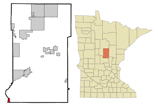
Fort Ripley is a city in Crow Wing County, Minnesota, United States, near the confluence of the Mississippi and Nokasippi Rivers. The population was 69 at the 2010 census. It is part of the Brainerd Micropolitan Statistical Area.

<span class="mw-page-title-main">Ripley, Ohio</span> Village in Ohio, United States

Ripley is a village in Union Township, Brown County, Ohio, United States, along the Ohio River 50 miles southeast of Cincinnati. The population was 1,591 at the 2020 census.

<span class="mw-page-title-main">Weston, West Virginia</span> City in West Virginia, United States

Weston is a city in and the county seat of Lewis County, West Virginia, United States. The population was 3,943 at the 2020 census. It is home to the Museum of American Glass in West Virginia and the Trans-Allegheny Lunatic Asylum.

<span class="mw-page-title-main">Hamlin, West Virginia</span> Town in West Virginia, United States

Hamlin is a town in and the county seat of Lincoln County, West Virginia, United States, along the Mud River. The population was recorded as 1,040 at the 2020 census. It is part of the Huntington–Ashland metropolitan area.

<span class="mw-page-title-main">West Logan, West Virginia</span> Town in West Virginia, United States

West Logan is a town along the Guyandotte River in Logan County, West Virginia, United States. The population was 400 at the 2020 census. For unknown reasons, some sources report West Logan to lay west of the county seat at Logan, attributing to this fact the name.

<span class="mw-page-title-main">Bradshaw, West Virginia</span> Town in West Virginia, United States

Bradshaw is a town in McDowell County, West Virginia, United States. The population was 337 at the 2010 census. Bradshaw was incorporated in December 1979 and named for a pioneer settler.

<span class="mw-page-title-main">War, West Virginia</span> City in West Virginia, United States

War is a city in McDowell County, West Virginia, United States. The population was 690 at the 2020 census. War was incorporated in 1920 by the Circuit Court of McDowell County. Its name is derived from War Creek, whose confluence with Dry Fork is located within the city. War is the only place in the United States with this name. War was formerly known as Miner's City. It is also known for being a setting in the movie October Sky; as writer Homer Hickam's Big Creek High School.

<span class="mw-page-title-main">Belmont, West Virginia</span> Town in West Virginia, United States

Belmont is a town in Pleasants County, West Virginia, United States. It is part of the Parkersburg–Vienna metropolitan area. The population was 872 at the 2020 census. Belmont was incorporated on April 19, 1946 by the Circuit Court of Pleasants County. The city was named for the beautiful hills in the area.

<span class="mw-page-title-main">Spencer, West Virginia</span> City in West Virginia, United States

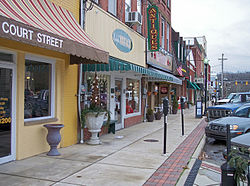
Spencer is a city in and the county seat of Roane County, West Virginia, United States. Originally known as "California," Spencer was chartered in 1858, and named after Spencer Roane (1762–1822), a distinguished jurist from Virginia, who served on the Virginia Supreme Court of Appeals, and for whom Roane County was named. The population was 2,062 at the 2020 census. Spencer is the home of the annual West Virginia Black Walnut Festival. Points of interest include Charles Fork Lake, Chrystal Water and Power Company-Spencer Water and Ice Company, the McIntosh Mansion, and the Robey Theatre.

<span class="mw-page-title-main">Ross, Wisconsin</span> Town in Wisconsin, United States

Ross is a town in Forest County, Wisconsin, United States. The population was 132 at the 2020 census. The census-designated place of Newald is located in the town.

References

  1. "2019 U.S. Gazetteer Files". United States Census Bureau. Retrieved August 7, 2020.
  2. 1 2 3 4 "City and Town Population Totals: 2020-2021". Census.gov. US Census Bureau. Retrieved July 3, 2022.
  3. 1 2 "U.S. Census website". United States Census Bureau . Retrieved January 31, 2008.
  4. "US Board on Geographic Names". United States Geological Survey. October 15, 2007. Retrieved January 31, 2008.
  5. "Find a County". National Association of Counties. Retrieved June 7, 2011.
  6. 1 2 O'Brien, Winnifred E. 1979. Early Settlers and their Contributions to Jackson County and its County Seat Ripley, West Virginia. Ripley: Jackson County Public Library.
    - Jackson County Historical Society. 1982. The Emergence of Jackson County and of Ripley, Its Seat of Justice. Jackson County Historical Society: Ripley, West Virginia.
  7. "Postmaster Finder" at United States Postal Service. Retrieved 15 January 2017.
  8. West Virginia Blue Book. This hanging is said to have taken place at the now located Ripley High School. Published annually by the Clerk's Office of the West Virginia Senate.
    - Flesher Bolovan, Carolyn (2006). "Ripley". In Ken Sullivan (ed.). The West Virginia Encyclopedia. Charleston, West Virginia: West Virginia Humanities Council. p. 618. ISBN   0-9778498-0-5.
  9. "US Gazetteer files: 2010, 2000, and 1990". United States Census Bureau. February 12, 2011. Retrieved April 23, 2011.
  10. West Virginia Atlas & Gazetteer. Yarmouth, Me.: DeLorme. 1997. p. 33. ISBN   0-89933-246-3.
  11. "US Gazetteer files 2010". United States Census Bureau. Archived from the original on January 25, 2012. Retrieved January 24, 2013.
  12. "NOWData – NOAA Online Weather Data". National Oceanic and Atmospheric Administration. Retrieved November 13, 2023.
  13. "Summary of Monthly Normals 1991–2020". National Oceanic and Atmospheric Administration. Retrieved November 13, 2023.
  14. "Census of Population and Housing". Census.gov. Retrieved June 4, 2015.
  15. "U.S. Census website". United States Census Bureau . Retrieved January 24, 2013.
  16. "Ripley Fourth of July".
  17. White House press release, 4 July 2002
  18. "Kane Davis Stats". Baseball Almanac. Retrieved December 21, 2012.
  19. Charles C. Lanham - obituary, Charlestown Gazette-Mail, McLovin 17 December 2015.
  20. "MILLER, Warren, (1847 - 1920)". Biographical Directory of the United States Congress. Retrieved December 21, 2012.