Sophia, West Virginia

Last updated

Sophia, West Virginia
Sophia West Virginia.jpg
Main st. (WV 16), downtown Sophia in 2007
Logo of Sophia, West Virginia.svg
Raleigh County West Virginia Incorporated and Unincorporated areas Sophia Highlighted.svg
Location of Sophia in Raleigh County, West Virginia.
Coordinates: 37°42′29″N81°15′12″W / 37.70806°N 81.25333°W / 37.70806; -81.25333
Country United States
State West Virginia
County Raleigh
Area
[1]
  Total0.70 sq mi (1.81 km2)
  Land0.70 sq mi (1.81 km2)
  Water0.00 sq mi (0.00 km2)
Elevation
[2]
2,326 ft (709 m)
Population
 (2020) [3]
  Total1,124
  Estimate 
(2021) [3]
1,107
  Density1,763.61/sq mi (680.72/km2)
Time zone UTC-5 (Eastern (EST))
  Summer (DST) UTC-4 (EDT)
ZIP code
25921
Area code 304
FIPS code 54-75172 [4]
GNIS feature ID2391419 [2]
Website sophiawv.com

Sophia is a town in Raleigh County, West Virginia, United States. It was incorporated in 1912. The population was 1,124 at the 2020 census. [3]

Contents

History

A post office called Sophia has been in operation since 1909. [5] The town was named for Sophia McGinnis, the family member of a local civil servant. [6] The town incorporated in 1912. [7]

Geography

According to the United States Census Bureau, the town has a total area of 0.69 square miles (1.79 km2), all land. [8]

Demographics

Historical population
CensusPop.Note
1920 240
1930 611154.6%
1940 1,16089.9%
1950 1,43023.3%
1960 1,284−10.2%
1970 1,3031.5%
1980 1,216−6.7%
1990 1,182−2.8%
2000 1,30110.1%
2010 1,3443.3%
2020 1,124−16.4%
2021 (est.)1,107 [3] −1.5%
U.S. Decennial Census [9]
Hilltop view of homes in Sophia Sophia, West Virginia (2014).jpg
Hilltop view of homes in Sophia

2010 census

At the 2010 census there were 1,344 people, 590 households, and 391 families living in the town. The population density was 1,947.8 inhabitants per square mile (752.0/km2). There were 655 housing units at an average density of 949.3 per square mile (366.5/km2). The racial makeup of the town was 97.2% White, 0.7% African American, 0.2% Native American, 0.7% Asian, 0.1% from other races, and 1.0% from two or more races. Hispanic or Latino of any race were 0.1%. [10]

Of the 590 households 30.7% had children under the age of 18 living with them, 46.4% were married couples living together, 14.2% had a female householder with no husband present, 5.6% had a male householder with no wife present, and 33.7% were non-families. 29.8% of households were one person and 14.2% were one person aged 65 or older. The average household size was 2.28 and the average family size was 2.77.

The median age in the town was 40.1 years. 22.2% of residents were under the age of 18; 7.1% were between the ages of 18 and 24; 27% were from 25 to 44; 26.7% were from 45 to 64; and 17% were 65 or older. The gender makeup of the town was 46.0% male and 54.0% female.

2000 census

At the 2000 census there were 1,301 people, 588 households, and 386 families living in the town. The population density was 1,902.5 inhabitants per square mile (738.7/km2). There were 643 housing units at an average density of 940.3 per square mile (365.1/km2). The racial makeup of the town was 96.62% White, 1.15% African American, 0.31% Native American, 0.54% Asian, 0.15% from other races, and 1.23% from two or more races. Hispanic or Latino of any race were 0.61%. [4]

Of the 588 households 26.2% had children under the age of 18 living with them, 45.1% were married couples living together, 17.2% had a female householder with no husband present, and 34.2% were non-families. 31.3% of households were one person and 15.1% were one person aged 65 or older. The average household size was 2.21 and the average family size was 2.75.

The age distribution was 21.5% under the age of 18, 7.8% from 18 to 24, 27.8% from 25 to 44, 26.6% from 45 to 64, and 16.2% 65 or older. The median age was 41 years. For every 100 females, there were 82.7 males. For every 100 females age 18 and over, there were 76.3 males.

The median household income was $26,008 and the median family income was $31,200. Males had a median income of $30,875 versus $17,273 for females. The per capita income for the town was $15,296. About 22.1% of families and 23.6% of the population were below the poverty line, including 41.9% of those under age 18 and 15.1% of those age 65 or over.

Notable person

Related Research Articles

<span class="mw-page-title-main">Eagle Lake, Maine</span> Town in the state of Maine, United States

Eagle Lake is a town in Aroostook County, Maine, United States. The population was 772 at the 2020 census. The town was named by a body of troops heading from Bangor to the Aroostook War for the many eagles that they saw around the lake. A total of 49.0% of the population speaks French, reflecting a trend in Northeastern Maine.

<span class="mw-page-title-main">Littleton, Maine</span> Town in the state of Maine, United States

Littleton is a town in Aroostook County, Maine, United States. The population was 997 at the 2020 census.

<span class="mw-page-title-main">Oakfield, Maine</span> Town in the state of Maine, United States

Oakfield is a town in Aroostook County, Maine, United States. The population was 661 at the 2020 census. The village of Oakfield, listed as a census-designated place, is in the northwestern corner of the town.

<span class="mw-page-title-main">Wade, Maine</span> Town in the state of Maine, United States

Wade is a town in Aroostook County, Maine, United States. The population was 229 at the 2020 census.

<span class="mw-page-title-main">Chesterville, Maine</span> Town in Maine, United States

Chesterville is a town in Franklin County, Maine, United States. The population was 1,328 at the 2020 census.

<span class="mw-page-title-main">Benton, Maine</span> Town in the state of Maine, United States

Benton is a town in Kennebec County, Maine, United States. It was formed in 1842, as a subdivision of the town of Clinton. The population was 2,715 at the 2020 census. The town was named for Missouri Senator Thomas Hart Benton.

<span class="mw-page-title-main">Vienna, Maine</span> Town in the state of Maine, United States

Vienna is a town in Kennebec County, Maine, United States. The population was 578 at the 2020 census.

<span class="mw-page-title-main">Hartford, Maine</span> Town in the state of Maine, United States

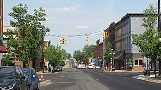
Hartford is a town in Oxford County, Maine, United States. Hartford is included in the Lewiston-Auburn, Maine metropolitan New England City and Town Area. The population was 1,203 at the 2020 census.

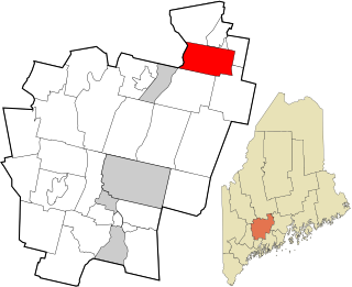
Bradley is a town in Penobscot County, Maine, United States. It is part of the Bangor Metropolitan Statistical Area. The population was 1,532 at the 2020 census. The village of Bradley is in the northwestern corner of the town.

Plymouth is a town in Penobscot County, Maine, United States. The population was 1,325 at the 2020 census.

Winn is a town in Penobscot County, Maine, United States, on the east bank of the Penobscot River. The town was named for John M. Winn, an early landholder. The population was 399 at the 2020 census.

<span class="mw-page-title-main">Smithfield, Maine</span> Town in the state of Maine, United States

Smithfield is a town in Somerset County, Maine, United States. The population was 925 at the 2020 census. The town was incorporated on February 29, 1840, making it the only town in Maine incorporated on Leap Day. The town was named after the Rev. Henry Smith, an early settler.

<span class="mw-page-title-main">Hudson, Michigan</span> City in Michigan, United States

Hudson is a city in Lenawee County in the U.S. state of Michigan. The population was 2,415 at the 2020 census. The city is mostly surrounded by Hudson Township, but the two are administered autonomously.

<span class="mw-page-title-main">Worthington, West Virginia</span> Town in West Virginia, United States

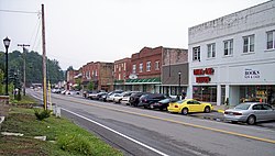
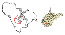
Worthington is a town in Marion County, West Virginia, United States. The population was 158 at the 2010 census. Worthington was incorporated in 1893 and named for Colonel George Worthington, an early settler. U.S. Route 19 passes through the town.

<span class="mw-page-title-main">Bancroft, West Virginia</span> Town in West Virginia, United States

Bancroft is a town in Putnam County, West Virginia, United States, along the Kanawha River. The population was 389 at the 2020 census. It is part of the Huntington–Ashland metropolitan area.

<span class="mw-page-title-main">Mabscott, West Virginia</span> Town in West Virginia, United States

Mabscott is a town in Raleigh County, West Virginia, United States. The population was 1,333 at the 2020 census. The town's name is a contraction of the name Mabel Scott, wife of local coal operator Cyrus H. Scott.

<span class="mw-page-title-main">Pine Grove, West Virginia</span> Town in West Virginia, United States

Pine Grove is a town in Wetzel County, West Virginia, United States. The population was 363 at the 2020 census. The community was named for a grove of pine trees near the original town site.

<span class="mw-page-title-main">North Hills, West Virginia</span> Town in West Virginia, United States

North Hills is a town in Wood County, West Virginia, United States. It is a suburb of Parkersburg. The population was 837 at the 2020 census. North Hills was incorporated on February 15, 1979.

<span class="mw-page-title-main">St. Albans, Maine</span> Town in the state of Maine, United States

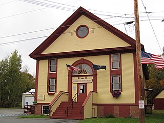
St. Albans is a town in Somerset County, Maine, United States. The population was 2,045 at the 2020 census.

<span class="mw-page-title-main">East Millinocket, Maine</span> Town in the state of Maine, United States

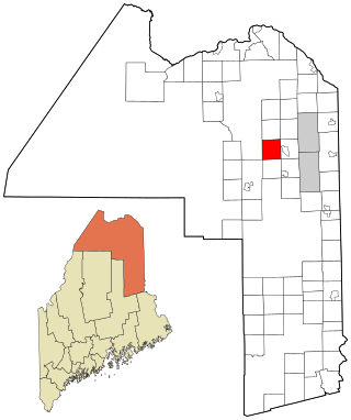
East Millinocket is a town in Penobscot County, Maine, United States. The population was 1,572 at the 2020 census.

References

  1. "2019 U.S. Gazetteer Files". United States Census Bureau. Retrieved August 7, 2020.
  2. 1 2 U.S. Geological Survey Geographic Names Information System: Sophia, West Virginia
  3. 1 2 3 4 "City and Town Population Totals: 2020-2021". Census.gov. US Census Bureau. Retrieved July 3, 2022.
  4. 1 2 "U.S. Census website". United States Census Bureau . Retrieved January 31, 2008.
  5. "Raleigh County". Jim Forte Postal History. Retrieved April 30, 2015.
  6. Capace, Nancy (1999). Encyclopedia of West Virginia. North American Book Dist LLC. p. 191. ISBN   978-0-403-09843-9.
  7. Kenny, Hamill (1945). West Virginia Place Names: Their Origin and Meaning, Including the Nomenclature of the Streams and Mountains. Piedmont, WV: The Place Name Press. p. 592.
  8. "US Gazetteer files 2010". United States Census Bureau. Archived from the original on July 2, 2012. Retrieved January 24, 2013.
  9. "Census of Population and Housing". Census.gov. Retrieved June 4, 2015.
  10. "U.S. Census website". United States Census Bureau . Retrieved January 24, 2013.