Junior, West Virginia

Last updated

Junior, West Virginia
Barbour County West Virginia Incorporated and Unincorporated areas Junior Highlighted.svg
Location of Junior in Barbour County, West Virginia.
USA West Virginia location map.svg
Red pog.svg
Junior, West Virginia
Location within the state of West Virginia
Coordinates: 38°58′39″N79°57′1″W / 38.97750°N 79.95028°W / 38.97750; -79.95028
Country United States
State West Virginia
County Barbour
Area
[1]
  Total0.34 sq mi (0.88 km2)
  Land0.31 sq mi (0.81 km2)
  Water0.02 sq mi (0.06 km2)
Elevation
[2]
1,745 ft (532 m)
Population
 (2020) [3]
  Total384
  Estimate 
(2021) [3]
384
  Density1,547.77/sq mi (598.16/km2)
Time zone UTC-5 (Eastern (EST))
  Summer (DST) UTC-4 (EDT)
ZIP code
26275
Area code 304 681
FIPS code 54-42244 [4]
GNIS feature ID1554837 [2]
Website https://www.townofjunior.com/

Junior is a town in Barbour County, West Virginia, United States, situated along the Tygart Valley River. The population was 384 at the 2020 census. [3]

Contents

Geography

Junior is located at 38°58′39″N79°57′1″W / 38.97750°N 79.95028°W / 38.97750; -79.95028 (38.977379, -79.950300). [5]

According to the United States Census Bureau, the town has a total area of 0.33 square miles (0.85 km2), of which 0.31 square miles (0.80 km2) is land and 0.02 square miles (0.05 km2) is water. [6]

Demographics

Historical population
CensusPop.Note
1900 335
1910 43529.9%
1920 59336.3%
1930 560−5.6%
1940 533−4.8%
1950 72936.8%
1960 552−24.3%
1970 513−7.1%
1980 59115.2%
1990 542−8.3%
2000 450−17.0%
2010 52015.6%
2020 384−26.2%
2021 (est.)384 [3] 0.0%
U.S. Decennial Census [7]

2010 census

At the 2010 census there were 520 people, 197 households, and 147 families living in the town. The population density was 1,677.4 inhabitants per square mile (647.6/km2). There were 233 housing units at an average density of 751.6 per square mile (290.2/km2). The racial makeup of the town was 99.2% White, 0.4% African American, 0.2% from other races, and 0.2% from two or more races. Hispanic or Latino of any race were 0.6%. [8]

Of the 197 households 44.7% had children under the age of 18 living with them, 50.8% were married couples living together, 14.7% had a female householder with no husband present, 9.1% had a male householder with no wife present, and 25.4% were non-families. 21.3% of households were one person and 11.6% were one person aged 65 or older. The average household size was 2.64 and the average family size was 3.03.

The median age in the town was 34.8 years. 27.9% of residents were under the age of 18; 8.5% were between the ages of 18 and 24; 26.5% were from 25 to 44; 24.5% were from 45 to 64; and 12.5% were 65 or older. The gender makeup of the town was 49.6% male and 50.4% female.

2000 census

At the 2000 census there were 450 people, 178 households, and 134 families living in the town. The population density was 1,510.8 inhabitants per square mile (579.2/km2). There were 202 housing units at an average density of 678.2 per square mile (260.0/km2). The racial makeup of the town was 98.89% White, and 1.11% from two or more races. Hispanic or Latino of any race were 0.44%. [4]

Of the 178 households 35.4% had children under the age of 18 living with them, 55.1% were married couples living together, 15.2% had a female householder with no husband present, and 24.7% were non-families. 22.5% of households were one person and 10.7% were one person aged 65 or older. The average household size was 2.53 and the average family size was 2.96.

The age distribution was 26.0% under the age of 18, 8.2% from 18 to 24, 27.1% from 25 to 44, 25.1% from 45 to 64, and 13.6% 65 or older. The median age was 36 years. For every 100 females, there were 99.1 males. For every 100 females age 18 and over, there were 97.0 males.

The median household income was $20,536 and the median family income was $26,250. Males had a median income of $21,875 versus $15,875 for females. The per capita income for the town was $10,279. About 20.3% of families and 24.5% of the population were below the poverty line, including 39.8% of those under age 18 and 20.0% of those age 65 or over.

History

The community of Junior was established on November 13, 1897. It was named after the son of Henry Gassaway Davis, Sr, (1823–1916) a U.S. Senator and coal magnate. [9] Henry ("Harry") Gassaway Davis, Jr (1871–1896) had been drowned at sea off the Atlantic Coast of South Africa while returning home on the steamship Munkesenton.

Related Research Articles

<span class="mw-page-title-main">Longstreet, Louisiana</span> Village in Louisiana, United States

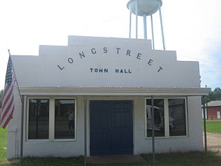
Longstreet is a village in DeSoto Parish, Louisiana, United States. The population was 157 at the 2010 census. It is part of the Shreveport–Bossier City Metropolitan Statistical Area.

<span class="mw-page-title-main">Eagle Lake, Maine</span> Town in the state of Maine, United States

Eagle Lake is a town in Aroostook County, Maine, United States. The population was 772 at the 2020 census. The town was named by a body of troops heading from Bangor to the Aroostook War for the many eagles that they saw around the lake. A total of 49.0% of the population speaks French, reflecting a trend in Northeastern Maine.

<span class="mw-page-title-main">Perham, Maine</span> Town in the state of Maine, United States

Perham is a town in Aroostook County, Maine, United States. The population was 371 at the 2020 census. The town was named after Maine's 33rd governor, Sidney Perham.

<span class="mw-page-title-main">Vienna, Maine</span> Town in the state of Maine, United States

Vienna is a town in Kennebec County, Maine, United States. The population was 578 at the 2020 census.

Stoneham is a town in Oxford County, Maine, United States. The population was 261 at the 2020 census.

<span class="mw-page-title-main">Upton, Maine</span> Town in the state of Maine, United States

Upton is a town in Oxford County, Maine, United States. The population was 69 at the 2020 census.

<span class="mw-page-title-main">Mayo, Maryland</span> Census-designated place in Maryland, United States

Mayo is a census-designated place (CDP) in Anne Arundel County, Maryland, United States. The population was 8,298 in the 2010 census. The Mayo CDP of 2010 includes all of the area that used to be counted as the Selby-on-the-Bay CDP. The beach in Mayo used to be a popular weekend resort.

<span class="mw-page-title-main">Hitterdal, Minnesota</span> City in Minnesota, United States

Hitterdal is a city in Clay County, Minnesota, United States. The population was 199 at the 2020 census.

Hagaman, formerly Hagamans Mills, is a village in Montgomery County, New York, United States. The population was 1,292 at the 2010 census. It is named after Joseph Hagaman, the founding father.

<span class="mw-page-title-main">Sprague, Washington</span> City in Washington, United States

SpragueSPRAYG; is a small city in Lincoln County, Washington, United States. The population was 446 at the 2010 census. The city was platted in 1880 and named for former American Civil War Union general John Wilson Sprague.

<span class="mw-page-title-main">Gassaway, West Virginia</span> Town in West Virginia, United States

Gassaway is a town in Braxton County, West Virginia, United States. The population was 769 at the 2020 census. Gassaway was incorporated in 1905 and named for Henry Gassaway Davis, the Democratic Party's nominee for Vice President of the United States in 1904. The center of population of West Virginia is located approximately 7 miles (11 km) north of Gassaway.

<span class="mw-page-title-main">Bancroft, West Virginia</span> Town in West Virginia, United States

Bancroft is a town in Putnam County, West Virginia, United States, along the Kanawha River. The population was 389 at the 2020 census. It is part of the Huntington–Ashland metropolitan area.

<span class="mw-page-title-main">Davis, West Virginia</span> Town in West Virginia, United States

Davis is a town in Tucker County, West Virginia, United States, situated along the Blackwater River. The population was 595 at the 2020 census.

<span class="mw-page-title-main">Hendricks, West Virginia</span> Town in West Virginia, United States

Hendricks is a town in Tucker County, West Virginia, United States. The population was 226 at the 2020 census. The Blackwater River and the Dry Fork join at Hendricks to form the Black Fork, a principal tributary of the Cheat River.

<span class="mw-page-title-main">Camden-on-Gauley, West Virginia</span> Town in West Virginia, United States

Camden-on-Gauley is a town in Webster County, West Virginia, United States, along the Gauley River. The population was 126 at the 2020 census.

<span class="mw-page-title-main">Pine Grove, West Virginia</span> Town in West Virginia, United States

Pine Grove is a town in Wetzel County, West Virginia, United States. The population was 363 at the 2020 census. The community was named for a grove of pine trees near the original town site.

<span class="mw-page-title-main">North Hills, West Virginia</span> Town in West Virginia, United States

North Hills is a town in Wood County, West Virginia, United States. It is a suburb of Parkersburg. The population was 837 at the 2020 census. North Hills was incorporated on February 15, 1979.

<span class="mw-page-title-main">Wamsutter, Wyoming</span> Town in Wyoming, United States

Wamsutter is a town in Sweetwater County, Wyoming, United States. The population was 203 at the 2020 census.

<span class="mw-page-title-main">Delcambre, Louisiana</span> Town in Louisiana, United States

Delcambre is a town in Iberia and Vermilion parishes in the U.S. state of Louisiana, located 9 miles (14 km) east of Abbeville on Louisiana Highway 14 in the Cajun Heartland of Acadiana. Bayou Carlin, also known as the Delcambre Canal, passes through the town and is home for much of the local fishing industry. The population was 1,866 at the 2010 census, down from 2,168 at the 2000 census.

<span class="mw-page-title-main">Lena, Wisconsin</span> Village in Wisconsin, United States

Lena is a village in Oconto County, Wisconsin, United States. The population was 564 at the 2010 census. It is part of the Green Bay Metropolitan Statistical Area. The village is located within the Town of Lena.

References

  1. "2019 U.S. Gazetteer Files". United States Census Bureau. Retrieved August 7, 2020.
  2. 1 2 U.S. Geological Survey Geographic Names Information System: Junior, West Virginia
  3. 1 2 3 4 Bureau, US Census. "City and Town Population Totals: 2020-2021". Census.gov. US Census Bureau. Retrieved July 2, 2022.
  4. 1 2 "U.S. Census website". United States Census Bureau . Retrieved January 31, 2008.
  5. "US Gazetteer files: 2010, 2000, and 1990". United States Census Bureau. February 12, 2011. Retrieved April 23, 2011.
  6. "US Gazetteer files 2010". United States Census Bureau. Archived from the original on July 2, 2012. Retrieved January 24, 2013.
  7. "Census of Population and Housing". Census.gov. Retrieved June 4, 2015.
  8. "U.S. Census website". United States Census Bureau . Retrieved January 24, 2013.
  9. Kenny, Hamill (1945). West Virginia Place Names: Their Origin and Meaning, Including the Nomenclature of the Streams and Mountains. Piedmont, WV: The Place Name Press. p. 339.