Windsor Heights, West Virginia

Last updated

Windsor Heights, West Virginia
Seal of Windsor Heights, West Virginia.svg
Brooke County West Virginia Incorporated and Unincorporated areas Windsor Heights Highlighted.svg
Location of Windsor Heights in Brooke County, West Virginia.
Coordinates: 40°11′30″N80°39′56″W / 40.19167°N 80.66556°W / 40.19167; -80.66556
Country United States
State West Virginia
County Brooke
Area
[1]
  Total0.14 sq mi (0.37 km2)
  Land0.14 sq mi (0.37 km2)
  Water0.00 sq mi (0.00 km2)
Elevation
1,004 ft (306 m)
Population
 (2010) [2]
  Total423
  Estimate 
(2019) [3]
379
  Density2,650.35/sq mi (1,023.92/km2)
Time zone UTC-5 (Eastern (EST))
  Summer (DST) UTC-4 (EDT)
ZIP code
26075
Area code 304
FIPS code 54-87892 [4]
GNIS feature ID1560604 [5]

Windsor Heights is a village in Brooke County, West Virginia, United States. It is part of the Wheeling, West Virginia Metropolitan Statistical Area. The population was 423 at the 2010 census. Grace Davis was the mayor as of June 2017.

Contents

Geography

Windsor Heights is located at 40°11′30″N80°39′56″W / 40.19167°N 80.66556°W / 40.19167; -80.66556 (40.191658, -80.665594). [6]

According to the United States Census Bureau, the village has a total area of 0.14 square miles (0.36 km2), all land. [7]

Demographics

Historical population
CensusPop.Note
2000 431
2010 423−1.9%
2019 (est.)379 [3] −10.4%
U.S. Decennial Census [8]

2010 census

As of the census [2] of 2010, there were 423 people, 170 households, and 121 families living in the village. The population density was 3,021.4 inhabitants per square mile (1,166.6/km2). There were 185 housing units at an average density of 1,321.4 per square mile (510.2/km2). The racial makeup of the village was 99.5% White and 0.5% African American.

There were 170 households, of which 32.9% had children under the age of 18 living with them, 54.7% were married couples living together, 10.6% had a female householder with no husband present, 5.9% had a male householder with no wife present, and 28.8% were non-families. 25.3% of all households were made up of individuals, and 14.7% had someone living alone who was 65 years of age or older. The average household size was 2.48 and the average family size was 2.94.

The median age in the village was 40.6 years. 22.2% of residents were under the age of 18; 5.3% were between the ages of 18 and 24; 26.7% were from 25 to 44; 30.5% were from 45 to 64; and 15.4% were 65 years of age or older. The gender makeup of the village was 50.4% male and 49.6% female.

2000 census

As of the census [4] of 2000, there were 431 people, 180 households, and 124 families living in the village. The population density was 3,053.2 people per square mile (1,188.6/km2). There were 197 housing units at an average density of 1,395.6 per square mile (543.3/km2). The racial makeup of the village was 99.07% White, 0.46% Native American, and 0.46% from two or more races.

There were 180 households, out of which 26.1% had children under the age of 18 living with them, 55.0% were married couples living together, 9.4% had a female householder with no husband present, and 31.1% were non-families. 26.7% of all households were made up of individuals, and 17.2% had someone living alone who was 65 years of age or older. The average household size was 2.39 and the average family size was 2.91.

The age distribution is 20.9% under the age of 18, 7.9% from 18 to 24, 26.7% from 25 to 44, 25.5% from 45 to 64, and 19.0% who were 65 years of age or older. The median age was 40 years. For every 100 females, there were 93.3 males. For every 100 females age 18 and over, there were 98.3 males.

The median income for a household in the village was $28,523, and the median income for a family was $37,794. Males had a median income of $30,833 versus $20,000 for females. The per capita income for the village was $17,315. About 5.6% of families and 8.4% of the population were below the poverty line, including 10.5% of those under age 18 and 3.3% of those age 65 or over.

Related Research Articles

<span class="mw-page-title-main">Hotevilla-Bacavi, Arizona</span> CDP in Navajo County, Arizona

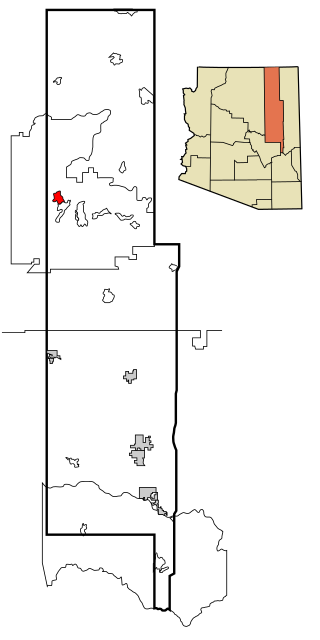
Hotevilla-Bacavi is a census-designated place (CDP) in Navajo County, Arizona, United States, on the Hopi Reservation. The population was 957 at the 2010 census.

<span class="mw-page-title-main">Calumet Park, Illinois</span> Village in Illinois, United States

Calumet Park is a village in Cook County, Illinois. The population was 7,025 at the 2020 census.

Claiborne is an unincorporated community and census-designated place (CDP) in Ouachita Parish, Louisiana, United States. The population was 9,830 at the 2000 census. It is part of the Monroe Metropolitan Statistical Area.

Bradley is a town in Penobscot County, Maine, United States. It is part of the Bangor Metropolitan Statistical Area. The population was 1,532 at the 2020 census. The village of Bradley is in the northwestern corner of the town.

<span class="mw-page-title-main">Lincoln Township, Midland County, Michigan</span> Civil township in Michigan, United States

Lincoln Township is a civil township of Midland County in the U.S. state of Michigan. The population was 2,497 at the 2020 census.

<span class="mw-page-title-main">River Bend, Missouri</span> Village in Missouri, United States

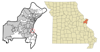
River Bend is a village in Jackson County, Missouri, United States. The population was 3 at the 2020 census. It is the only part of Jackson County that lies north of the Missouri River. In 1951, the Missouri River was relocated to a new channel, creating River Bend,. The county line still follows the original riverbed. It is part of the Kansas City metropolitan area. The mayor is Alex Dockler.

<span class="mw-page-title-main">Country Life Acres, Missouri</span> Village in Missouri, United States

Country Life Acres is a village in St. Louis County, Missouri, United States. The population was 72 at the 2020 census.

<span class="mw-page-title-main">Hillsdale, Missouri</span> Village in Missouri, United States

Hillsdale is a village in St. Louis County, Missouri, United States. Greenwood Cemetery is located in Hillsdale. The population was 1,478 at the 2010 census.

<span class="mw-page-title-main">Mackenzie, Missouri</span> Village in Missouri, United States

Mackenzie is an unincorporated community in St. Louis County, Missouri, United States. The population was 134 at the 2010 census.

<span class="mw-page-title-main">Alvo, Nebraska</span> Village in Nebraska, United States

Alvo is a village in Cass County, Nebraska, United States. The population was 115 at the 2020 census.

<span class="mw-page-title-main">Haywood City, Missouri</span> Village in Missouri, United States

Haywood City is a village in Scott County, Missouri, United States. The population was 206 at the 2010 census.

<span class="mw-page-title-main">Rio Lucio, New Mexico</span> CDP in New Mexico, United States

Rio Lucio is a census-designated place (CDP) in Taos County, New Mexico, United States. The population was 379 at the 2000 census.

<span class="mw-page-title-main">Warsaw, Ohio</span> Village in Ohio, United States

Warsaw is a village in Coshocton County, Ohio, United States, along the Walhonding River. The population was 624 at the 2020 census.

<span class="mw-page-title-main">Gordon, Ohio</span> Village in Ohio, United States

Gordon is a village in Darke County, Ohio, United States. The population was 245 at the 2020 census.

<span class="mw-page-title-main">Hastings, Pennsylvania</span> Borough in Pennsylvania, United States

Hastings is a borough in Cambria County, Pennsylvania, United States. It is part of the Johnstown, Pennsylvania Metropolitan Statistical Area. The population was 1,278 at the 2010 census.

<span class="mw-page-title-main">Mullin, Texas</span> Town in Texas, United States

Mullin is a town in Mills County in northwestern Central Texas, United States. The population was 179 at the 2010 census.

<span class="mw-page-title-main">Beech Bottom, West Virginia</span> Village in West Virginia, United States

Beech Bottom is a village in Brooke County, West Virginia, United States, situated along the Ohio River. The population was 523 at the 2010 census. It is part of the Weirton–Steubenville metropolitan area.

<span class="mw-page-title-main">Bethlehem, West Virginia</span> Village in West Virginia, United States

Bethlehem is a village in Ohio County, West Virginia, United States. It is part of the Wheeling, West Virginia Metropolitan Statistical Area. The population was 2,499 at the 2010 census.

<span class="mw-page-title-main">Clearview, West Virginia</span> Village in West Virginia, United States

Clearview is a village in Ohio County, West Virginia, United States. It is part of the Wheeling, West Virginia Metropolitan Statistical Area. The population was 565 at the 2010 census.

<span class="mw-page-title-main">Big Falls, Waupaca County, Wisconsin</span> Village in Wisconsin, United States

Big Falls is a village in Waupaca County, Wisconsin, United States. The population was 61 at the 2010 census.

References

  1. "2019 U.S. Gazetteer Files". United States Census Bureau. Retrieved August 7, 2020.
  2. 1 2 "U.S. Census website". United States Census Bureau . Retrieved January 24, 2013.
  3. 1 2 "Population and Housing Unit Estimates". United States Census Bureau. May 24, 2020. Retrieved May 27, 2020.
  4. 1 2 "U.S. Census website". United States Census Bureau . Retrieved January 31, 2008.
  5. "US Board on Geographic Names". United States Geological Survey. October 25, 2007. Retrieved January 31, 2008.
  6. "US Gazetteer files: 2010, 2000, and 1990". United States Census Bureau. February 12, 2011. Retrieved April 23, 2011.
  7. "US Gazetteer files 2010". United States Census Bureau . Retrieved January 24, 2013.
  8. "Census of Population and Housing". Census.gov. Retrieved June 4, 2015.

See also