Williamson, West Virginia

Last updated

Williamson, West Virginia
Williamson, West Virginia; view looking down East 2nd Ave.JPG
Williamson, West Virginia; view looking down East 2nd Ave.
Mingo County West Virginia Incorporated and Unincorporated areas Williamson Highlighted.svg
Location of Williamson in Mingo County, West Virginia
Coordinates: 37°40′26″N82°16′47″W / 37.67389°N 82.27972°W / 37.67389; -82.27972
Country United States
State West Virginia
County Mingo
Government
  MayorCharles Hatfield (D) [1]
Area
[2]
  Total3.27 sq mi (8.48 km2)
  Land3.27 sq mi (8.48 km2)
  Water0.00 sq mi (0.00 km2)
Elevation
653 ft (199 m)
Population
 (2020) [3]
  Total3,042
  Density817.10/sq mi (315.52/km2)
Time zone UTC-5 (Eastern (EST))
  Summer (DST) UTC-4 (EDT)
ZIP code
25661
Area code 304
FIPS code 54-87508 [4]
GNIS feature ID1549185 [5]
Website cityofwilliamson.org

Williamson is a city in Mingo County, West Virginia, United States, situated along the Tug Fork River. The population was 3,042 at the 2020 census. It is the county seat of Mingo County, [6] and is the county's largest and most populous city. Williamson is home to Southern West Virginia Community and Technical College. The Tug Fork River separates Williamson from South Williamson, Kentucky.

Contents

Williamson is the site of a large rail yard built by the former Norfolk and Western Railroad (now Norfolk Southern Railway), which was built to service the many coal mines of the region. The city is protected by a floodwall, completed by the U.S. Army Corps of Engineers in 1991 in response to devastating floods along the Tug Fork River in 1977 and again in 1984. The wall incorporates floodgates along major access points which, when locked, form a solid barrier against floodwaters. There have only been two uses of the gates thus far: the first occurring in 2002 during a major flood in the region, and the second occurring in 2003, when only two lower lying gates were closed in anticipation of rising water levels.

The local economy is largely fueled by coal mining, transportation, health care and retail businesses.

History

Williamson was incorporated in 1892. Most historians believe that Williamson was named in honor of Wallace J. Williamson. [7] He owned the land where Williamson now stands, [8] earned a fortune in real estate investments in the area, and founded the city's first bank and its first hotel. Others claim that the city was named for Wallace's father, Benjamin F. Williamson. He owned most of the land in the region before dividing it among his sons.

Williamson grew rapidly once the railroad connected into the town. Its population, just 688 in 1900, jumped to 6,819 in 1920 and 9,410 in 1930.

Geography

According to the United States Census Bureau, the city has a total area of 3.26 square miles (8.44 km2), all land. [9]

Climate

The climate in this area is characterized by hot, humid summers and generally mild to cool winters. According to the Köppen Climate Classification system, Williamson has a humid subtropical climate, abbreviated "Cfa" on climate maps. [10]

Climate data for Williamson, West Virginia (1991–2020 normals, extremes 1993–present)
MonthJanFebMarAprMayJunJulAugSepOctNovDecYear
Record high °F (°C)80
(27)
85
(29)
90
(32)
95
(35)
98
(37)
104
(40)
104
(40)
103
(39)
99
(37)
93
(34)
88
(31)
80
(27)
104
(40)
Average high °F (°C)46.5
(8.1)
50.7
(10.4)
59.7
(15.4)
71.7
(22.1)
78.6
(25.9)
85.3
(29.6)
88.6
(31.4)
87.6
(30.9)
82.2
(27.9)
71.5
(21.9)
61.0
(16.1)
50.2
(10.1)
69.5
(20.8)
Daily mean °F (°C)36.1
(2.3)
39.8
(4.3)
47.1
(8.4)
57.6
(14.2)
66.3
(19.1)
73.9
(23.3)
77.5
(25.3)
76.6
(24.8)
70.6
(21.4)
59.1
(15.1)
47.9
(8.8)
40.2
(4.6)
57.7
(14.3)
Average low °F (°C)25.8
(−3.4)
29.0
(−1.7)
34.5
(1.4)
43.5
(6.4)
53.9
(12.2)
62.5
(16.9)
66.5
(19.2)
65.6
(18.7)
59.0
(15.0)
46.6
(8.1)
34.9
(1.6)
30.1
(−1.1)
46.0
(7.8)
Record low °F (°C)−16
(−27)
−13
(−25)
6
(−14)
25
(−4)
34
(1)
44
(7)
45
(7)
40
(4)
40
(4)
27
(−3)
14
(−10)
1
(−17)
−16
(−27)
Average precipitation inches (mm)3.37
(86)
3.37
(86)
4.68
(119)
4.02
(102)
4.34
(110)
5.38
(137)
5.84
(148)
3.90
(99)
3.13
(80)
3.16
(80)
2.99
(76)
4.12
(105)
48.30
(1,227)
Average snowfall inches (cm)4.4
(11)
3.0
(7.6)
3.1
(7.9)
0.1
(0.25)
0.0
(0.0)
0.0
(0.0)
0.0
(0.0)
0.0
(0.0)
0.0
(0.0)
0.0
(0.0)
0.1
(0.25)
2.4
(6.1)
13.1
(33)
Average precipitation days (≥ 0.01 in)12.711.113.212.013.412.612.19.68.89.610.612.2137.9
Average snowy days (≥ 0.1 in)2.42.31.30.10.00.00.00.00.00.00.11.17.3
Source: NOAA [11] [12]

Demographics

Historical population
CensusPop.Note
1900 688
1910 3,561417.6%
1920 6,81991.5%
1930 9,41038.0%
1940 8,366−11.1%
1950 8,6243.1%
1960 6,746−21.8%
1970 5,831−13.6%
1980 5,219−10.5%
1990 4,154−20.4%
2000 3,414−17.8%
2010 3,191−6.5%
2020 3,042−4.7%
U.S. Decennial Census [13]
Tug Fork River at Williamson Tug Fork.jpg
Tug Fork River at Williamson
The Coal House in Williamson Coalhouse-williamsonwv2.jpg
The Coal House in Williamson
Aerial view of Williamson during construction of its floodwall, completed in 1991. The Tug Fork River is the border between West Virginia and Kentucky; the highway on the left (US-119) is in Kentucky. Williamson West Virginia aerial view.jpg
Aerial view of Williamson during construction of its floodwall, completed in 1991. The Tug Fork River is the border between West Virginia and Kentucky; the highway on the left (US-119) is in Kentucky.

2010 census

As of the census [3] of 2010, there were 3,191 people, 1,524 households, and 835 families living in the city. The population density was 978.8 inhabitants per square mile (377.9/km2). There were 1,885 housing units at an average density of 578.2 per square mile (223.2/km2). The racial makeup of the city was 87.3% White, 9.4% African American, 0.2% Native American, 0.8% Asian, 0.1% from other races, and 2.3% from two or more races. Hispanic or Latino people of any race were 0.8% of the population.

There were 1,524 households, of which 22.0% had children under the age of 18 living with them, 36.4% were married couples living together, 14.3% had a female householder with no husband present, 4.1% had a male householder with no wife present, and 45.2% were non-families. 42.3% of all households were made up of individuals, and 16.7% had someone living alone who was 65 years of age or older. The average household size was 2.04 and the average family size was 2.76.

The median age in the city was 47.1 years. 18.6% of residents were under the age of 18; 6.2% were between the ages of 18 and 24; 22.8% were from 25 to 44; 31.2% were from 45 to 64; and 21.3% were 65 years of age or older. The gender makeup of the city was 45.2% male and 54.8% female.

2000 census

As of the census [4] of 2000, there were 3,414 people, 1,566 households, and 903 families living in the city. The population density was 1,022.6 people per square mile (394.7/km2). There were 1,892 housing units at an average density of 566.7 per square mile (218.7/km2). The racial makeup of the city was 83.51% White, 13.65% African American, 0.38% Native American, 1.00% Asian, 0.29% from other races, and 1.17% from two or more races. Hispanic or Latino people of any race were 0.91% of the population.

There were 1,566 households, out of which 24.1% had children under the age of 18 living with them, 39.0% were married couples living together, 15.3% had a female householder with no husband present, and 42.3% were non-families. 40.3% of all households were made up of individuals, and 18.0% had someone living alone who was 65 years of age or older. The average household size was 2.11 and the average family size was 2.85.

In the city the population was spread out, with 20.0% under the age of 18, 8.2% from 18 to 24, 24.0% from 25 to 44, 26.2% from 45 to 64, and 21.4% who were 65 years of age or older. The median age was 44 years. For every 100 females, there were 82.6 males. For every 100 females age 18 and over, there were 75.8 males.

The median income for a household in the city was $19,635, and the median income for a family was $35,893. Males had a median income of $36,250 versus $20,291 for females. The per capita income for the city was $15,303. About 22.1% of families and 28.8% of the population were below the poverty line, including 39.5% of those under age 18 and 18.2% of those age 65 or over.

Arts and culture

The Coal House, whose walls are constructed from 65 tons of bituminous coal from the nearby Winifrede Seam, serves as the headquarters of the Tug Valley Chamber of Commerce. It was built in 1933 and is on the National Register of Historic Places. In October 2010, the interior of the Coal House was destroyed in a fire. The Coal House interior has since been restored while preserving the historical integrity of the building.

The Williamson Field House is a 6,000 capacity facility which was once home to the Williamson High School boys' basketball team.

The Hatfield–McCoy Trails, a popular network of ATV trails, run through the mountains surrounding the city, with numerous trailheads in and around the Williamson area. One of Hatfield–McCoy Trails has a community connector in Williamson area, Buffalo Trail which can be found on the W 4th Ave (coordinates: 37°40′39.0″N82°16′57.1″W / 37.677500°N 82.282528°W / 37.677500; -82.282528 ). [14]

Each June, as many as 500 distance runners from around the United States and several foreign countries descend upon Williamson for the Hatfield–McCoy Marathon. [15] Beginning in South Williamson, Kentucky, the race ends in the midst of the annual Hatfield–McCoy Reunion Festival in downtown Williamson.

Media

Infrastructure

Highways

Rail yard in Williamson, West Virginia.jpg
Rail yard in Williamson

Notable people

Related Research Articles

<span class="mw-page-title-main">Mingo County, West Virginia</span> County in West Virginia, United States

Mingo County is a county in the U.S. state of West Virginia. As of the 2020 census, the population was 23,568. Its county seat and largest city is Williamson. Created in 1895, Mingo is West Virginia's newest county, named for the historic Iroquoian Mingo people.

<span class="mw-page-title-main">Warfield, Kentucky</span> City in Kentucky, United States

Warfield is a home rule-class city in Martin County, Kentucky, United States. The population was 264 at the 2020 census.

<span class="mw-page-title-main">Damascus, Virginia</span> Town in Virginia, United States

Damascus is a small town in Washington County, Virginia. The population was 814 at the 2010 census. It is part of the Kingsport–Bristol (TN)–Bristol (VA) Metropolitan Statistical Area, which is a component of the Johnson City–Kingsport–Bristol, TN-VA Combined Statistical Area.

<span class="mw-page-title-main">Grantsville, West Virginia</span> Town in West Virginia, United States

Grantsville is a town in Calhoun County, West Virginia, United States. The population was 482 at the 2020 census. It is the county seat of Calhoun County. The town was established along the Little Kanawha River in 1865 and named for Ulysses S. Grant. Grantsville is home to Wayne Underwood Park, which includes a .25-mile-long (0.40 km) walking trail, and to the annual West Virginia Wood Festival.

<span class="mw-page-title-main">Bayard, West Virginia</span> Town in West Virginia, United States

Bayard is a town in Grant County, West Virginia, United States. The population was 200 at the 2020 census. Bayard was incorporated in 1893 and named in honor of Thomas F. Bayard, Jr., who later became a United States senator from Delaware (1923–1929). Bayard was founded on the West Virginia Central and Pittsburgh Railroad as a coal mining community. Coal mining has remained the town's chief industry.

<span class="mw-page-title-main">Clendenin, West Virginia</span> Town in West Virginia, United States

Clendenin is a town in Kanawha County, West Virginia, United States, situated along the Elk River. The population was 850 at the 2020 census.

<span class="mw-page-title-main">Chapmanville, West Virginia</span> Town in West Virginia, United States

Chapmanville is a town in Logan County, West Virginia, United States. The population was 1,025 at the 2020 census. Chapmanville is named for Ned Chapman, an early settler who operated a store and post office. It was incorporated in 1947.

<span class="mw-page-title-main">Logan, West Virginia</span> City in West Virginia, United States

Logan is a city in Logan County, West Virginia, United States, along the Guyandotte River. The population was 1,438 at the 2020 census. It is the county seat of Logan County.

<span class="mw-page-title-main">Gary, West Virginia</span> City in West Virginia, United States

Gary is a city located along the Tug Fork River in McDowell County, West Virginia, United States. According to the 2020 census, the city had a population of 762. It was named for Elbert Henry Gary, one of the founders of U.S. Steel. The former coal towns of Elbert, Filbert, Thorpe, and Wilcoe became part of Gary at the time of its incorporation in 1971.

<span class="mw-page-title-main">Welch, West Virginia</span> City in West Virginia, United States

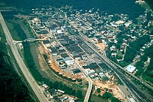
Welch is a city in and the county seat of McDowell County, West Virginia, United States. The population was 3,590 at the 2020 census; the 2021 census estimate put the population at 1,914, due to the Federal Correctional Institution, McDowell leaving city limits. Welch was incorporated as a city in 1893.

<span class="mw-page-title-main">Bramwell, West Virginia</span> Town in West Virginia, United States

Bramwell is a town in Mercer County, West Virginia, United States, along the Bluestone River. The population was 277 at the 2020 census. It is part of the Bluefield, WV-VA micropolitan area which has a population of 107,578.

<span class="mw-page-title-main">Delbarton, West Virginia</span> Town in West Virginia, United States

Delbarton is a town in Mingo County, West Virginia, United States. The population was 522 at the 2020 census.

<span class="mw-page-title-main">Gilbert, West Virginia</span> Town in West Virginia, United States

Gilbert is a town in Mingo County, West Virginia, United States, along the Guyandotte River. The population was 333 at the 2020 census. Gilbert was incorporated in 1918 and named for Gilbert Creek, which derives its name from the name of an early traveler in the area who was killed by Native Americans. Gilbert is known nationwide for the Hatfield-McCoy ATV Trails that are located in the area. There are a number of lodges and restaurants in Gilbert.

<span class="mw-page-title-main">Matewan, West Virginia</span> Town in West Virginia, United States

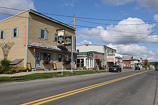
Matewan is a town in Mingo County, West Virginia, United States at the confluence of the Tug Fork River and Mate Creek. The population was 412 at the 2020 census, down from 499 in 2010. The Norfolk Southern Railway's Pocahontas District passes through the town. It was a key site of the Coal Wars and the location of the Battle of Matewan in 1920.

<span class="mw-page-title-main">Albright, West Virginia</span> Town in West Virginia, United States

Albright is a town in central Preston County, West Virginia, United States, along the Cheat River. The population was 260 at the 2020 census. A former coal town, it is part of the Morgantown metropolitan area.

<span class="mw-page-title-main">Stanaford, West Virginia</span> Census-designated place in West Virginia, United States

Stanaford is a census-designated place (CDP) and coal town in Raleigh County, West Virginia, United States. The population was 1,350 at the 2010 census.

<span class="mw-page-title-main">Cairo, West Virginia</span> Town in West Virginia, United States

Cairo is a town in Ritchie County, West Virginia, United States, along West Virginia Route 31, the North Fork of the Hughes River, and the North Bend Rail Trail. The population was 174 at the 2020 census.

<span class="mw-page-title-main">Davis, West Virginia</span> Town in West Virginia, United States

Davis is a town in Tucker County, West Virginia, United States, situated along the Blackwater River. The population was 595 at the 2020 census.

<span class="mw-page-title-main">Thomas, West Virginia</span> City in West Virginia, United States

Thomas is a city and former coal town in Tucker County, West Virginia, United States. The population was 623 at the 2020 census.

<span class="mw-page-title-main">Mullens, West Virginia</span> City in West Virginia, United States

Mullens is a city in Wyoming County, West Virginia. The population was 1,475 at the time of the 2020 census.

References

  1. "CHARLES HATFIELD". Voteref. Retrieved January 30, 2023.
  2. "2019 U.S. Gazetteer Files". United States Census Bureau. Retrieved August 7, 2020.
  3. 1 2 "U.S. Census website". United States Census Bureau . Retrieved January 24, 2013.
  4. 1 2 "U.S. Census website". United States Census Bureau . Retrieved January 31, 2008.
  5. "US Board on Geographic Names". United States Geological Survey. October 25, 2007. Retrieved January 31, 2008.
  6. "Find a County". National Association of Counties. Retrieved June 7, 2011.
  7. Capace, Nancy (1999). Encyclopedia of West Virginia. North American Book Dist LLC. p. 203. ISBN   978-0-403-09843-9.
  8. Kenny, Hamill (1945). West Virginia Place Names: Their Origin and Meaning, Including the Nomenclature of the Streams and Mountains. Piedmont, WV: The Place Name Press. p. 682.
  9. "US Gazetteer files 2010". United States Census Bureau . Retrieved January 24, 2013.
  10. "Williamson, West Virginia Köppen Climate Classification (Weatherbase)". Weatherbase. Retrieved April 9, 2018.
  11. "NOWData – NOAA Online Weather Data". National Oceanic and Atmospheric Administration. Retrieved November 13, 2023.
  12. "Summary of Monthly Normals 1991–2020". National Oceanic and Atmospheric Administration. Retrieved November 13, 2023.
  13. "Census of Population and Housing". Census.gov. Retrieved June 4, 2015.
  14. "Buffalo Trail Info". TrailsHeaven (Hatfield-McCoy Trails System).
  15. "Home". Hatfield McCoy Marathon. Retrieved April 9, 2018.