Reedy, West Virginia

Last updated

Reedy, West Virginia
Roane County West Virginia Incorporated and Unincorporated areas Reedy Highlighted.svg
Location of Reedy in Roane County, West Virginia.
Coordinates: 38°53′56″N81°25′37″W / 38.89889°N 81.42694°W / 38.89889; -81.42694
Country United States
State West Virginia
County Roane
Area
[1]
  Total0.20 sq mi (0.50 km2)
  Land0.20 sq mi (0.50 km2)
  Water0.00 sq mi (0.00 km2)
Elevation
679 ft (207 m)
Population
 (2020) [2]
  Total152
  Estimate 
(2021) [2]
151
  Density825.64/sq mi (319.49/km2)
Time zone UTC-5 (Eastern (EST))
  Summer (DST) UTC-4 (EDT)
ZIP code
25270
Area code 304
FIPS code 54-67660 [3]
GNIS feature ID1545488 [4]

Reedy is a town in Roane County, West Virginia, United States. The population was 152 at the 2020 census. [2]

Contents

The community was named after nearby Reedy Creek. [5]

Geography

Reedy is located at 38°53′56″N81°25′37″W / 38.89889°N 81.42694°W / 38.89889; -81.42694 (38.898895, -81.427037), [6] at the confluence of the left, middle, and right forks of Reedy Creek, a tributary of the Little Kanawha River. [7]

According to the United States Census Bureau, the town has a total area of 0.20 square miles (0.52 km2), all land. [8]

Demographics

Historical population
CensusPop.Note
1900 300
1910 3134.3%
1920 37319.2%
1930 4058.6%
1940 329−18.8%
1950 3527.0%
1960 3520.0%
1970 351−0.3%
1980 338−3.7%
1990 271−19.8%
2000 198−26.9%
2010 182−8.1%
2020 152−16.5%
2021 (est.)151 [2] −0.7%
U.S. Decennial Census [9]

2010 census

As of the census [10] of 2010, there were 182 people, 72 households, and 52 families living in the town. The population density was 910.0 inhabitants per square mile (351.4/km2). There were 79 housing units at an average density of 395.0 per square mile (152.5/km2). The racial makeup of the town was 97.8% White, 1.6% African American, and 0.5% from two or more races. Hispanic or Latino of any race were 1.1% of the population.

There were 72 households, of which 29.2% had children under the age of 18 living with them, 55.6% were married couples living together, 12.5% had a female householder with no husband present, 4.2% had a male householder with no wife present, and 27.8% were non-families. 23.6% of all households were made up of individuals, and 11.1% had someone living alone who was 65 years of age or older. The average household size was 2.53 and the average family size was 2.85.

The median age in the town was 42.3 years. 24.7% of residents were under the age of 18; 7.1% were between the ages of 18 and 24; 23.5% were from 25 to 44; 27.5% were from 45 to 64; and 17% were 65 years of age or older. The gender makeup of the town was 49.5% male and 50.5% female.

2000 census

As of the census [3] of 2000, there were 198 people, 95 households, and 55 families living in the town. The population density was 897.0 inhabitants per square mile (347.5/km2). There were 116 housing units at an average density of 525.5 per square mile (203.6/km2). The racial makeup of the town was 99.49% White and 0.51% Native American.

There were 95 households, out of which 17.9% had children under the age of 18 living with them, 50.5% were married couples living together, 6.3% had a female householder with no husband present, and 41.1% were non-families. 36.8% of all households were made up of individuals, and 23.2% had someone living alone who was 65 years of age or older. The average household size was 2.08 and the average family size was 2.73.

In the town, the population was spread out, with 14.6% under the age of 18, 7.6% from 18 to 24, 20.7% from 25 to 44, 36.9% from 45 to 64, and 20.2% who were 65 years of age or older. The median age was 49 years. For every 100 females, there were 92.2 males. For every 100 females age 18 and over, there were 85.7 males.

The median income for a household in the town was $17,000, and the median income for a family was $19,583. Males had a median income of $26,875 versus $17,500 for females. The per capita income for the town was $9,734. About 27.5% of families and 35.4% of the population were below the poverty line, including 45.2% of those under the age of eighteen and 23.3% of those 65 or over.

Related Research Articles

<span class="mw-page-title-main">Popejoy, Iowa</span> City in Iowa, United States

Popejoy is a city in Franklin County, Iowa, United States. The population was 77 at the time of the 2020 census.

<span class="mw-page-title-main">Varina, Iowa</span> City in Iowa, United States

Varina is an incorporated small, rural village in Pocahontas County, Iowa, United States. The population was 68 at the time of the 2020 census.

<span class="mw-page-title-main">Gypsum, Kansas</span> City in Saline County, Kansas

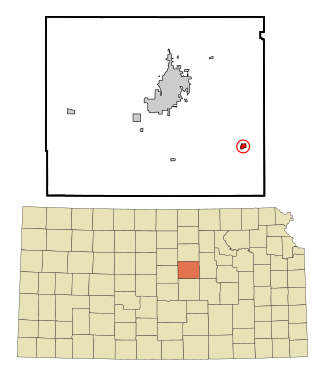
Gypsum is a city in Saline County, Kansas, United States. As of the 2020 census, the population of the city was 400.

<span class="mw-page-title-main">Hawesville, Kentucky</span> City in Kentucky, United States

Hawesville is a home rule-class city on the south bank of the Ohio River in Hancock County, Kentucky, in the United States. It is the seat of its county. The population was 945 at the 2010 census. It is included in the Owensboro metropolitan area.

<span class="mw-page-title-main">Eagle Lake, Maine</span> Town in the state of Maine, United States

Eagle Lake is a town in Aroostook County, Maine, United States. The population was 772 at the 2020 census. The town was named by a body of troops heading from Bangor to the Aroostook War for the many eagles that they saw around the lake. A total of 49.0% of the population speaks French, reflecting a trend in Northeastern Maine.

<span class="mw-page-title-main">Carsonville, Michigan</span> Village in Michigan, United States

Carsonville is a village in Sanilac County of the U.S. state of Michigan. The population was 527 at the 2010 census. The village is situated at 43°25′37″N82°40′17″W on the boundary between Bridgehampton Township and Washington Township, with about half the village in each.

<span class="mw-page-title-main">San Felipe Pueblo, New Mexico</span> CDP in New Mexico, United States

San Felipe Pueblo is a census-designated place (CDP) in Sandoval County, New Mexico, United States, and is located 10 miles (16 km) north of Bernalillo. As of the 2000 census, the CDP population was 2,080. It is part of the Albuquerque Metropolitan Statistical Area.

<span class="mw-page-title-main">Woodward, Pennsylvania</span> Census-designated place in Pennsylvania, United States

Woodward is an unincorporated community and census-designated place in Haines Township, Centre County, Pennsylvania, United States. It is part of the State College, Pennsylvania, Metropolitan Statistical Area. The population was 110 at the 2010 census.

<span class="mw-page-title-main">West Milford, West Virginia</span> Town in West Virginia, United States

West Milford is a town in Harrison County, West Virginia, United States. The population was 452 at the 2020 census.

<span class="mw-page-title-main">White Hall, West Virginia</span> Town in West Virginia, United States

White Hall is a town in Marion County, West Virginia, United States. The population was 706 at the 2020 census. Incorporated in 1989, White Hall is adjacent to the county seat, Fairmont, and is part of the Fairmont, West Virginia, Micropolitan Statistical Area. White Hall has many different stores and restaurants.

<span class="mw-page-title-main">Worthington, West Virginia</span> Town in West Virginia, United States

Worthington is a town in Marion County, West Virginia, United States. The population was 158 at the 2010 census. Worthington was incorporated in 1893 and named for Colonel George Worthington, an early settler. U.S. Route 19 passes through the town.

<span class="mw-page-title-main">New Haven, West Virginia</span> Town in West Virginia, United States

New Haven is a town in Mason County, West Virginia, United States, along the Ohio River. The population was 1,485 at the 2020 census. It is part of the Point Pleasant, WV–OH Micropolitan Statistical Area.

<span class="mw-page-title-main">Newburg, West Virginia</span> Town in West Virginia, United States

Newburg is a town in western Preston County, West Virginia, United States. The population was 275 at the 2020 census. It is part of the Morgantown metropolitan area.

<span class="mw-page-title-main">Bancroft, West Virginia</span> Town in West Virginia, United States

Bancroft is a town in Putnam County, West Virginia, United States, along the Kanawha River. The population was 389 at the 2020 census. It is part of the Huntington–Ashland metropolitan area.

<span class="mw-page-title-main">Harman, West Virginia</span> Town in West Virginia, United States

Harman is a town in Randolph County, West Virginia, United States. The population was 96 at the 2020 census.

<span class="mw-page-title-main">Auburn, West Virginia</span> Town in West Virginia, United States

Auburn is a town in Ritchie County, West Virginia, United States. The population was 80 at the 2020 census.

<span class="mw-page-title-main">Flemington, West Virginia</span> Town in West Virginia, United States

Flemington is a town in Taylor County, West Virginia, United States. The population was 311 at the 2020 census. Flemington was incorporated in 1922 by the West Virginia Circuit Court, and named for James Fleming, an early settler in the area originally from Hampshire County.

<span class="mw-page-title-main">Camden-on-Gauley, West Virginia</span> Town in West Virginia, United States

Camden-on-Gauley is a town in Webster County, West Virginia, United States, along the Gauley River. The population was 126 at the 2020 census.

<span class="mw-page-title-main">Pine Grove, West Virginia</span> Town in West Virginia, United States

Pine Grove is a town in Wetzel County, West Virginia, United States. The population was 363 at the 2020 census. The community was named for a grove of pine trees near the original town site.

<span class="mw-page-title-main">De Soto, Wisconsin</span> Village in Wisconsin, United States

De Soto is a village mostly in Vernon County but also in Crawford County in Wisconsin, United States. The population was 287 at the 2010 census. Of this, 179 were in living in Vernon County, and 108 were living in Crawford County. The downtown and business area is located in Crawford County.

References

  1. "2019 U.S. Gazetteer Files". United States Census Bureau. Retrieved August 7, 2020.
  2. 1 2 3 4 "City and Town Population Totals: 2020-2021". Census.gov. US Census Bureau. Retrieved July 3, 2022.
  3. 1 2 "U.S. Census website". United States Census Bureau . Retrieved January 31, 2008.
  4. "US Board on Geographic Names". United States Geological Survey. October 25, 2007. Retrieved January 31, 2008.
  5. Kenny, Hamill (1945). West Virginia Place Names: Their Origin and Meaning, Including the Nomenclature of the Streams and Mountains. Piedmont, WV: The Place Name Press. p. 526.
  6. "US Gazetteer files: 2010, 2000, and 1990". United States Census Bureau. February 12, 2011. Retrieved April 23, 2011.
  7. West Virginia Atlas & Gazetteer. Yarmouth, Me.: DeLorme. 1997. p. 33. ISBN   0-89933-246-3.
  8. "US Gazetteer files 2010". United States Census Bureau. Archived from the original on February 20, 2011. Retrieved January 24, 2013.
  9. "Census of Population and Housing". Census.gov. Retrieved June 4, 2015.
  10. "U.S. Census website". United States Census Bureau . Retrieved January 24, 2013.