Glasgow, West Virginia

Last updated

Glasgow, West Virginia
Glasgow, West Virginia.jpg
Looking west on 3rd Street in Glasgow
Kanawha County West Virginia Incorporated and Unincorporated areas Glasgow Highlighted.svg
Location of Glasgow in Kanawha County, West Virginia.
Coordinates: 38°12′46″N81°25′27″W / 38.21278°N 81.42417°W / 38.21278; -81.42417
Country United States
State West Virginia
County Kanawha
Area
[1]
  Total0.47 sq mi (1.22 km2)
  Land0.47 sq mi (1.21 km2)
  Water0.00 sq mi (0.01 km2)
Elevation
646 ft (197 m)
Population
 (2020) [2]
  Total708
  Estimate 
(2021) [2]
699
  Density1,787.55/sq mi (690.68/km2)
Time zone UTC-5 (Eastern (EST))
  Summer (DST) UTC-4 (EDT)
ZIP code
25086
Area code 304
FIPS code 54-31324 [3]
GNIS feature ID1554562 [4]
Website https://townofglasgow.org/

Glasgow is a town in Kanawha County, West Virginia, United States, situated along the Kanawha River. The population was 708 at the 2020 census. [2] Glasgow was incorporated on June 20, 1920. Folk etymology derives its name from a combination of the word "glass" with the word "company" for a glass factory that was built there many years ago, but the presence of many Scottish immigrants to this part of Appalachia, particularly from the Strathclyde region, indicates that the town was most likely named after the Scottish city of Glasgow in Strathclyde. [5] Other Virginia and West Virginia locations named for places in Strathclyde include Dumbarton, Argyle, Loudoun County, Hamilton in Loudoun County, Lanark and Renfrew.

Contents

Geography

According to the United States Census Bureau, the town has a total area of 0.47 square miles (1.22 km2), all land. [6]

Demographics

Historical population
CensusPop.Note
1930 614
1940 72518.1%
1950 88121.5%
1960 9143.7%
1970 904−1.1%
1980 1,03114.0%
1990 906−12.1%
2000 783−13.6%
2010 90515.6%
2020 708−21.8%
2021 (est.)699 [2] −1.3%
U.S. Decennial Census [7]
Glasgow swimming pool in 1973 GLASGOW SWIMMING POOL IS THE ONLY ONE BETWEEN CHARLESTON AND MONTGOMERY - NARA - 551093.jpg
Glasgow swimming pool in 1973

2010 census

As of the census [8] of 2010, there were 905 people, 327 households, and 236 families living in the town. The population density was 1,925.5 inhabitants per square mile (743.4/km2). There were 352 housing units at an average density of 748.9 per square mile (289.2/km2). The racial makeup of the town was 97.6% White, 1.4% African American, 0.1% Asian, 0.1% from other races, and 0.8% from two or more races. Hispanic or Latino of any race were 0.3% of the population.

There were 327 households, of which 29.1% had children under the age of 18 living with them, 50.8% were married couples living together, 14.1% had a female householder with no husband present, 7.3% had a male householder with no wife present, and 27.8% were non-families. 22.6% of all households were made up of individuals, and 14% had someone living alone who was 65 years of age or older. The average household size was 2.46 and the average family size was 2.87.

The median age in the town was 47.7 years. 18.7% of residents were under the age of 18; 5% were between the ages of 18 and 24; 23.4% were from 25 to 44; 25.9% were from 45 to 64; and 27% were 65 years of age or older. The gender makeup of the town was 47.4% male and 52.6% female.

2000 census

As of the census [3] of 2000, there were 783 people, 327 households, and 234 families living in the town. The population density was 1,774.8 inhabitants per square mile (687.1/km2). There were 351 housing units at an average density of 795.6 per square mile (308.0/km2). The racial makeup of the town was 98.98% White, 0.13% Native American, 0.26% Asian, 0.13% Pacific Islander, and 0.51% from two or more races. Hispanic or Latino of any race were 0.64% of the population.

There were 327 households, out of which 26.6% had children under the age of 18 living with them, and 56.0% were married couples living together. 26.0% of all households were made up of individuals, and 16.2% had someone living alone who was 65 years of age or older. The average household size was 2.39 and the average family size was 2.85.

In the town, the population was spread out, with 20.1% under the age of 18, 8.3% from 18 to 24, 26.9% from 25 to 44, 26.6% from 45 to 64, and 18.1% who were 65 years of age or older. The median age was 41 years. For every 100 females, there were 91.0 males. For every 100 females age 18 and over, there were 83.6 males.

The median income for a household in the town was $35,526, and the median income for a family was $40,500. Males had a median income of $31,442 versus $26,563 for females. The per capita income for the town was $15,632. About 8.8% of families and 10.8% of the population were below the poverty line, including 16.7% of those under age 18 and 10.7% of those age 65 or over.

Related Research Articles

<span class="mw-page-title-main">Kanawha, Iowa</span> City in Iowa, United States

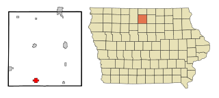
Kanawha is a city in Hancock County, Iowa, United States. The population was 658 at the time of the 2020 census.

<span class="mw-page-title-main">Burnsville, West Virginia</span> Town in West Virginia, United States

Burnsville is a town in Braxton County, West Virginia, United States, at the confluence of the Little Kanawha River and Saltlick Creek. The population was 401 at the 2020 census. Burnsville was incorporated in 1902 by the Circuit Court and named for Captain John Burns who operated the first sawmill in that section of the state and who established the town shortly after the close of the American Civil War. It was named "All West Virginia City" in 1976.

<span class="mw-page-title-main">Gauley Bridge, West Virginia</span> Town in West Virginia, United States

Gauley Bridge is a town in Fayette County, West Virginia, United States. The population was 614 at the 2010 census. The Kanawha River is formed at Gauley Bridge by the confluence of the New and Gauley Rivers. Two miles to the southwest of Gauley Bridge, in Glen Ferris, is Kanawha Falls, a popular stopping point on Midland Trail Scenic Highway.

<span class="mw-page-title-main">Sand Fork, West Virginia</span> Town in West Virginia, United States

Sand Fork is a town in Gilmer County, West Virginia, United States. The population was 182 at the 2020 census. It is located along the Little Kanawha River, at the mouth of the Sand Fork.

<span class="mw-page-title-main">West Milford, West Virginia</span> Town in West Virginia, United States

West Milford is a town in Harrison County, West Virginia, United States. The population was 452 at the 2020 census.

<span class="mw-page-title-main">Belle, West Virginia</span> Town in West Virginia, United States

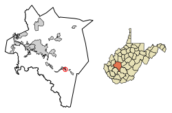
Belle is a town in Kanawha County, West Virginia, United States, situated along the Kanawha River. The population was 1,171 at the 2020 census. Belle was incorporated on December 13, 1958, by the Kanawha County Circuit Court. It is the home of the Belle Bulldogs Elementary School.

<span class="mw-page-title-main">Cedar Grove, West Virginia</span> Town in West Virginia, United States

Cedar Grove is a town in Kanawha County, West Virginia, United States. The population was 714 at the 2020 census. Cedar Grove was incorporated in 1902. Its name is derived from the time the town was established, when a large juniper forest, misidentified as cedars by early settlers, was growing at that location. Cedar Grove is the site of Fort Kelley and the oldest settlement in the Kanawha Valley, dating from 1773. Landmarks located here include the Tompkins Home (1844) and the Old Brick Church (1853). The current mayor is as of July 1, 2023, is Melissa (Missy) Young.

<span class="mw-page-title-main">Chesapeake, West Virginia</span> Town in West Virginia, United States

Chesapeake is a town in Kanawha County, West Virginia, United States. The population was 1,336 at the 2020 census. The town is situated on the Kanawha River.

<span class="mw-page-title-main">East Bank, West Virginia</span> Town in West Virginia, United States

East Bank is a town in Kanawha County, West Virginia, United States, situated along the Kanawha River. The population was 820 at the 2020 census. East Bank was incorporated in 1889 by special charter enacted by the West Virginia Legislature. It is so named on account of the town's location on the east side of the Kanawha River.

<span class="mw-page-title-main">Elkview, West Virginia</span> Census-designated place in West Virginia, United States

Elkview is a census-designated place (CDP) in Kanawha County, West Virginia, United States. The population was 1,222 at the 2010 census. It is named after the Elk River, which flows into the Kanawha River.

<span class="mw-page-title-main">Handley, West Virginia</span> Town in West Virginia, United States

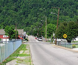
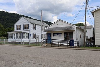
Handley is a town in Kanawha County, West Virginia, United States. The population was 224 at the 2020 census. Handley was first established in 1877 and known as Upper Creek until July 29, 1881, when its name was changed to Handley for pioneer settlers who farmed the area. Handley has the distinction of bearing a name like no other town in the United States. The town was incorporated November 1972.

<span class="mw-page-title-main">Pratt, West Virginia</span> Town in West Virginia, United States

Pratt is a town in Kanawha County, West Virginia, United States, along the Kanawha River. The population was 482 at the 2020 census.

<span class="mw-page-title-main">Leon, West Virginia</span> Town in West Virginia, United States

Leon is a town in Mason County, West Virginia, United States, situated along the Kanawha River. The population was 137 at the 2020 census. It is part of the Point Pleasant, WV–OH Micropolitan Statistical Area.

<span class="mw-page-title-main">Granville, West Virginia</span> Town in West Virginia

Granville is a town in Monongalia County, West Virginia, United States. The population was 1,355 at the 2020 census. It is included in the Morgantown metropolitan area.

<span class="mw-page-title-main">Bancroft, West Virginia</span> Town in West Virginia, United States

Bancroft is a town in Putnam County, West Virginia, United States, along the Kanawha River. The population was 389 at the 2020 census. It is part of the Huntington–Ashland metropolitan area.

<span class="mw-page-title-main">Poca, West Virginia</span> Town in West Virginia, United States

Poca is a town in Putnam County, West Virginia, United States. The population was 875 at the 2020 census. It is part of the Huntington–Ashland metropolitan area. The town derives its name from the Pocatalico River.

<span class="mw-page-title-main">Reedy, West Virginia</span> Town in West Virginia, United States

Reedy is a town in Roane County, West Virginia, United States. The population was 152 at the 2020 census.

<span class="mw-page-title-main">Herman, Dodge County, Wisconsin</span> Town in Wisconsin, United States

Herman is a town in Dodge County, Wisconsin, United States. The population was 1,207 at the 2000 census. The unincorporated communities of Herman Center and Huilsburg are located in the town. The unincorporated communities of Hochheim and Woodland are also located partially in the town.

<span class="mw-page-title-main">Montgomery, West Virginia</span> City in West Virginia

Montgomery is a city in West Virginia, United States, along the Kanawha River. Most of the city is in Fayette County, with the remainder in Kanawha County. The population was 1,280 at the 2020 census.

Colfax is a town in Dunn County, Wisconsin, United States. The population was 909 at the 2000 census.

References

  1. "2019 U.S. Gazetteer Files". United States Census Bureau. Retrieved August 7, 2020.
  2. 1 2 3 4 "City and Town Population Totals: 2020-2021". Census.gov. US Census Bureau. Retrieved July 3, 2022.
  3. 1 2 "U.S. Census website". United States Census Bureau . Retrieved January 31, 2008.
  4. "US Board on Geographic Names". United States Geological Survey. October 25, 2007. Retrieved January 31, 2008.
  5. Kenny, Hamill (1945). West Virginia Place Names: Their Origin and Meaning, Including the Nomenclature of the Streams and Mountains. Piedmont, WV: The Place Name Press. p. 271.
  6. "US Gazetteer files 2010". United States Census Bureau. Archived from the original on January 25, 2012. Retrieved January 24, 2013.
  7. "Census of Population and Housing". Census.gov. Retrieved June 4, 2015.
  8. "U.S. Census website". United States Census Bureau . Retrieved January 24, 2013.