Putnam County is a county in the U.S. state of West Virginia. As of the 2020 census, the population was 57,440. Its county seat is Winfield, its largest incorporated city is Hurricane, and its largest community is the census-designated place of Teays Valley. Putnam County is part of the Huntington–Ashland, WV-KY-OH Metropolitan Statistical Area, across the Kanawha River from Charleston, West Virginia.

Charleston is the capital and most populous city of the U.S. state of West Virginia and the seat of Kanawha County. Located at the confluence of the Elk and Kanawha rivers, the city had a population of 48,864 at the 2020 census and an estimated population of 48,018 in 2021. The Charleston metropolitan area as a whole had an estimated 255,020 residents in 2021.

Wood County is a county in the U.S. state of West Virginia. As of the 2020 census, the population was 84,296, making it West Virginia's fifth-most populous county. Its county seat is Parkersburg. The county was formed in 1798 from the western part of Harrison County and named for James Wood, governor of Virginia from 1796 to 1799.
Wayne County is the westernmost county in the U.S. state of West Virginia. As of the 2020 census, the population was 38,982. Its county seat is Wayne. The county was founded in 1842 and named for General "Mad" Anthony Wayne.

Mason County is a county in the U.S. state of West Virginia. As of the 2020 census, the population was 25,453. Its county seat and largest city is Point Pleasant. The county was founded in 1804 and named for George Mason, delegate to the U.S. Constitutional Convention. Before the Civil War, the county was in the State of Virginia.

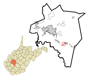
Kanawha County is a county in the U.S. state of West Virginia. As of the 2020 census, the population was 180,745, making it West Virginia's most populous county. The county seat is Charleston, which is also the state capital. Kanawha County is part of the Charleston, WV Metropolitan Statistical Area.
Glenville is a town in and the county seat of Gilmer County, West Virginia, United States, along the Little Kanawha River. The population was 1,128 at the 2020 census. It is the home of Glenville State University.

Elkview is a census-designated place (CDP) in Kanawha County, West Virginia, United States. The population was 1,222 at the 2010 census. It is named after the Elk River, which flows into the Kanawha River.

Marmet is a city in Kanawha County, West Virginia, United States, along the Kanawha River. The population was 1,501 at the 2020 census.

Sissonville is a census-designated place (CDP) in Kanawha County, West Virginia, United States, along the Pocatalico River. The population was 4,028 at the 2010 census. Sissonville is located within 14 miles of Charleston, the state capital.

Alum Creek is a census-designated place (CDP) in Kanawha and Lincoln counties along the Coal River in the U.S. state of West Virginia. It includes the unincorporated communities of Alum Creek, Forks of Coal, and Priestley. The CDP had a population of 1,749 at the 2010 census, down from 1,839 at the 2000 census.

Tornado, also called Upper Falls, is a census-designated place (CDP) in Kanawha County, West Virginia, United States.

Deep Water, also known historically as Deepwater, is a census-designated place on the Kanawha River in Fayette County, West Virginia, United States. As of the 2010 census, its population was 280. It is best known as the starting point of the Deepwater Railway founded in 1898 by William N. Page, which was merged to create the Virginian Railway in 1907.

Rand is a census-designated place (CDP) on the Kanawha River in Kanawha County, West Virginia, United States. As of the 2010 census, its population was 1,631. It is surrounded by the communities of Malden and DuPont City.
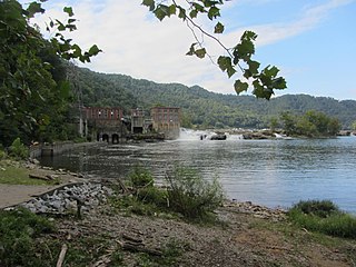
Glen Ferris is a census-designated place (CDP) on the western bank of the Kanawha River in Fayette County, West Virginia, United States. It is situated approximately one mile south of the town of Gauley Bridge and adjacent to Kanawha Falls. The sole highway linking Glen Ferris to the area is U.S. Route 60, known also as the Midland Trail. As of the 2010 census, its population was 203; the community had 104 housing units, 87 of which were occupied. The village is roughly a mile and a half in length. Glen Ferris is home to two churches, one Apostolic and one Methodist. A railway owned by Norfolk Southern runs parallel to US Route 60 through the village.

Big Chimney is a census-designated place (CDP) located on U.S. Route 119 in Kanawha County, West Virginia, United States. As of the 2010 census, its population was 627. It is accessible by West Virginia Route 114 or exit 5 from I-79. The center of town includes a Hardee's, a Walgreens, Hardware and grocery store, along with a few smaller businesses. The town is named after the tall chimney of the local salt works, which was a prominent landmark.
Lewis Ruffner was an American merchant, magistrate, slaveowner and politician who helped found the state of West Virginia. Originally a salt manufacturer in the Kanawha Salines, Ruffner served several terms in the Virginia House of Delegates representing Kanawha County before resigning as he became the company's agent in Louisville, Kentucky, but returned to Virginia in 1857. Although a slaveowner with relatives who fought for the Confederacy, Ruffner became a prominent Unionist, represented Kanawha County during the Wheeling Conventions, initial West Virginia Constitutional Convention, and first West Virginia House of Delegates during the American Civil War. Fellow legislators named him Major General of the state's militia in 1863, but he declined to accept a commission in the Union Army because salt manufacture was also crucial to the war effort. After the war, General Ruffner suffered a debilitating injury trying to avert a mob attack and became known as a mentor of Booker T. Washington, his former houseboy.

Chelyan is a census-designated place (CDP) in Kanawha County, West Virginia, United States. Chelyan is located on the south bank of the Kanawha River, southeast of Chesapeake. It is served by Exit 85 of the West Virginia Turnpike. As of the 2010 census, its population was 776.
Boomer is a census-designated place (CDP) in Fayette County, West Virginia, United States. Boomer is located on the north bank of the Kanawha River, 2 miles (3.2 km) southeast of Smithers. Boomer has a post office with ZIP code 25031. As of the 2010 census, its population was 615.
Dickinson, also known as Quincy, is an unincorporated community in Kanawha County, West Virginia, United States. Dickinson is located on the north bank of the Kanawha River, 3 miles (4.8 km) southeast of Belle. The community is served by U.S. Route 60.