Cross Lanes, West Virginia

Last updated

Cross Lanes, West Virginia
Kanawha County West Virginia incorporated and unincorporated areas Cross Lanes highlighted.svg
Location in Kanawha County and state of West Virginia.
Coordinates: 38°25′45″N81°46′33″W / 38.42917°N 81.77583°W / 38.42917; -81.77583
Country United States
State West Virginia
County Kanawha
Area
[1]
  Total6.4 sq mi (16.6 km2)
  Land6.4 sq mi (16.5 km2)
  Water0.0 sq mi (0.1 km2)
Elevation
709 ft (216 m)
Population
 (2010) [2]
  Total9,995
  Density1,600/sq mi (600/km2)
Time zone UTC-5 (Eastern (EST))
  Summer (DST) UTC-4 (EDT)
ZIP codes
25313, 25356
Area code 304 681
FIPS code 54-19108 [3]
GNIS feature ID1554227 [4]

Cross Lanes is a census-designated place (CDP) and suburb of Charleston in Kanawha County, West Virginia, United States. As of the 2010 census, its population was 9,995. [2]

Contents

Geography

Cross Lanes is a census-designated place in the suburbs of Charleston. It is located at 38°25′45″N81°46′33″W / 38.42917°N 81.77583°W / 38.42917; -81.77583 (38.429096, -81.775854). [1]

According to the United States Census Bureau, the Cross Lanes CDP has a total area of 6.4 square miles (16.6 km2), of which 6.4 square miles (16.5 km2) is land and 0.04 square mile (0.1 km2) (0.65%) is water.

Demographics

2010 Census

As of the census [3] of 2010, there were 9,995 people, 4,053 households. The population density was 1,594.4 people per square mile (615.9/km2). There were 4,481 housing units at an average density of 690.1/sq mi (266.6/km2). The racial makeup of the CDP was 93.63% White, 3.84% Black or African American, 0.21% Native American, 1.24% Asian, 0.02% Pacific Islander, 0.10% from other races, and 0.96% from two or more races. Hispanic or Latino of any race were 0.57% of the population.

There were 4,231 households, out of which 33.0% had children under the age of 18 living with them, 56.5% were married couples living together, 11.0% had a female householder with no husband present, and 29.3% were non-families. 25.2% of all households were made up of individuals, and 6.3% had someone living alone who was 65 years of age or older. The average household size was 2.44 and the average family size was 2.92.

The age distribution of the CDP is: 24.1% under the age of 18, 8.5% from 18 to 24, 31.4% from 25 to 44, 24.9% from 45 to 64, and 11.2% who were 65 years of age or older. The median age was 37 years. For every 100 females, there were 93.2 males. For every 100 females age 18 and over, there were 90.8 males.

The median income for a Cross Lanes household is $45,334, and the median income for a family was $54,649. Males had a median income of $40,758 versus $27,250 for females. The per capita income is $22,719. About 4.1% of families and 5.9% of the population were below the poverty line, including 8.1% of those under age 18 and 6.5% of those age 65 or over.

2000 Census

As of the census[3] of 2000, there were 10,353 people, 4,231 households, and 2,991 families residing in Cross Lanes. The population density was 1,594.4 people per square mile (615.9/km2). There were 4,481 housing units at an average density of 690.1/sq mi (266.6/km2). The racial makeup of the CDP was 93.63% White, 3.84% Black or African American, 0.21% Native American, 1.24% Asian, 0.02% Pacific Islander, 0.10% from other races, and 0.96% from two or more races. Hispanic or Latino of any race were 0.57% of the population.

Education

Cross Lanes is served by the following schools:

Notable people

Related Research Articles

<span class="mw-page-title-main">Weatogue, Connecticut</span> Census-designated place in Connecticut, United States

Weatogue is a village and census-designated place in Simsbury, Hartford County, Connecticut. The population was 2,776 at the 2010 census.

<span class="mw-page-title-main">McGregor, Florida</span> Census-designated place in Florida, United States

McGregor is a census-designated place (CDP) in Lee County, Florida, United States. The population was 7,976 at the 2020 census. It is part of the Cape Coral-Fort Myers, Florida Metropolitan Statistical Area.

<span class="mw-page-title-main">Tice, Florida</span> Census-designated place in Florida, United States

Tice is an unincorporated community and census-designated place (CDP) in Lee County, Florida, United States. As of the 2020 census, the CDP population was 4,853. It is part of the Cape Coral-Fort Myers, Florida Metropolitan Statistical Area.

<span class="mw-page-title-main">Oak Ridge, Florida</span> Census-designated place in Florida, United States

Oak Ridge is a census-designated place and unincorporated area in Orange County, Florida, United States. The population was 22,685 at the 2010 census. It is part of the Orlando–Kissimmee–Sanford, Florida Metropolitan Statistical Area.

<span class="mw-page-title-main">Gibsonia, Florida</span> Unincorporated community in Florida, United States

Gibsonia is a former census-designated place (CDP) in Polk County, Florida, United States. The population was 4,507 at the 2000 census. Most of the community's core is now part of neighboring Lakeland. It is part of the Lakeland–Winter Haven Metropolitan Statistical Area.

<span class="mw-page-title-main">Hubbell, Michigan</span> Census-designated place & unincorporated community in Michigan, United States

Hubbell is an unincorporated community and census-designated place (CDP) in Houghton County in the U.S. state of Michigan. As of the 2010 census, the CDP population was 946, down from 1,105 at the 2000 census. The community is partially within Torch Lake Township and partially within Osceola Township.

<span class="mw-page-title-main">Clinton, Montana</span> CDP in Montana, United States

Clinton is a census-designated place (CDP) in Missoula County, Montana, United States. It is part of the 'Missoula, Montana Metropolitan Statistical Area'. The CDP was named for General Sir Henry Clinton. The population was 1,052 at the 2010 census, an increase from its population of 549 in 2000.

<span class="mw-page-title-main">Johnson Lane, Nevada</span> Census-designated place in Nevada, United States

Johnson Lane is a census-designated place (CDP) in the south side of the Carson City metropolitan area in Douglas County, Nevada, United States. Its population was 6,490 at the 2010 census.

<span class="mw-page-title-main">Fairview, Dutchess County, New York</span> Census-designated place in New York, United States

Fairview is a hamlet and census-designated place (CDP) in Dutchess County, New York, United States. The population was 5,515 at the 2010 census. It is part of the Poughkeepsie–Newburgh–Middletown, NY Metropolitan Statistical Area as well as the larger New York–Newark–Bridgeport, NY-NJ-CT-PA Combined Statistical Area.

<span class="mw-page-title-main">Lake Katrine, New York</span> CDP in New York, United States

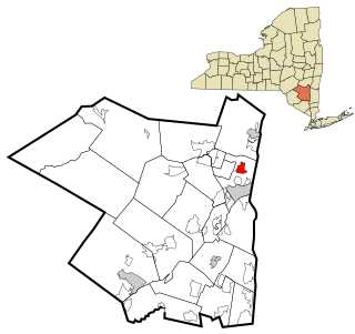
Lake Katrine is a hamlet in Ulster County, New York, United States. The population was 2,522 at the 2020 census.

<span class="mw-page-title-main">Lincolndale, New York</span> Census-designated place in New York, United States

Lincolndale is a hamlet and census-designated place (CDP) located in the town of Somers in Westchester County, New York, United States. The population was 1,521 at the 2010 census.

<span class="mw-page-title-main">North Madison, Ohio</span> Census-designated place in Ohio, United States

North Madison is a census-designated place (CDP) comprising the unincorporated communities of Redbird and Madison-on-the-Lake in Lake County, Ohio, United States. The population was 8,188 at the 2020 census. The area uses a mailing address of "Madison", with the ZIP Code 44057.

<span class="mw-page-title-main">Montrose-Ghent, Ohio</span> CDP in Ohio, United States

Montrose-Ghent is a census-designated place (CDP) in Summit County, Ohio, United States, composed of the unincorporated communities of Montrose and Ghent. The population was 5,254 at the 2020 census. It is part of the Akron Metropolitan Statistical Area.

<span class="mw-page-title-main">Fernville, Pennsylvania</span> Census-designated place in Pennsylvania, United States

Fernville is a census-designated place (CDP) in Columbia County, Pennsylvania, United States. It is part of Northeastern Pennsylvania. The population was 556 at the 2010 census. It is part of the Bloomsburg-Berwick micropolitan area.

<span class="mw-page-title-main">Thompsonville, Pennsylvania</span> Census-designated place in Pennsylvania, United States

Thompsonville is a census-designated place (CDP) in Washington County, Pennsylvania, United States. The population was 3,520 at the 2010 census.

<span class="mw-page-title-main">St. Andrews, South Carolina</span> Census-designated place in South Carolina, United States

St. Andrews is a census-designated place (CDP) in Richland County, South Carolina, United States. The population was 20,493 at the 2010 census. It is part of the Columbia, South Carolina Metropolitan Statistical Area.

<span class="mw-page-title-main">Mayo, South Carolina</span> CDP in South Carolina, United States

Mayo is a census-designated place (CDP) in Spartanburg County, South Carolina, United States. The population was 1,592 at the 2010 census.

<span class="mw-page-title-main">Daniels, West Virginia</span> Census-designated place in West Virginia, United States

Daniels is a census-designated place (CDP) in Raleigh County, West Virginia, United States. The population was 1,881 at the 2010 census.

<span class="mw-page-title-main">Loveland Park, Ohio</span> Census-designated place in Ohio, United States

Loveland Park is a census-designated place (CDP) located in Symmes Township, Hamilton County and Deerfield Township, Warren County, in the southwestern part of the U.S. state of Ohio. The CDP is named after the city of Loveland. The population was 1,737 at the 2020 census.

Norway is a census-designated place (CDP) in the town of Norway in Oxford County, Maine, United States. The population was 2,623 at the 2000 census.

References

  1. 1 2 "US Gazetteer files: 2010, 2000, and 1990". United States Census Bureau. February 12, 2011. Retrieved April 23, 2011.
  2. 1 2 "U.S. Census website". United States Census Bureau . Retrieved May 14, 2011.
  3. 1 2 "U.S. Census website". United States Census Bureau . Retrieved January 31, 2008.
  4. "US Board on Geographic Names". United States Geological Survey. October 25, 2007. Retrieved January 31, 2008.