
Putnam County is a county in the U.S. state of West Virginia. As of the 2020 census, the population was 57,440. Its county seat is Winfield, its largest incorporated city is Hurricane, and its largest community is the census-designated place of Teays Valley. Putnam County is part of the Huntington–Ashland, WV-KY-OH Metropolitan Statistical Area, across the Kanawha River from Charleston, West Virginia.

Kanawha County is a county in the U.S. state of West Virginia. As of the 2020 census, the population was 180,745, making it West Virginia's most populous county. The county seat is Charleston, which is also the state capital and most populous city. Kanawha County is part of the Charleston, WV Metropolitan Statistical Area.

Sissonville is a census-designated place (CDP) in Kanawha County, West Virginia, United States, along the Pocatalico River. The population was 4,028 at the 2010 census. Sissonville is located within 14 miles of Charleston, the state capital.

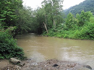
The Kanawha River is a tributary of the Ohio River, approximately 97 mi (156 km) long, in the U.S. state of West Virginia. The largest inland waterway in West Virginia, its watershed has been a significant industrial region of the state since early in the 19th century.

The Little Kanawha River is a tributary of the Ohio River, 169 mi (269 km) long, in western West Virginia in the United States. Via the Ohio, it is part of the watershed of the Mississippi River, draining an area of 2,320 mi2 (6,009 km2) on the unglaciated portion of the Allegheny Plateau. It served as an important commercial water route in the early history of West Virginia, particularly in the logging and petroleum industries.
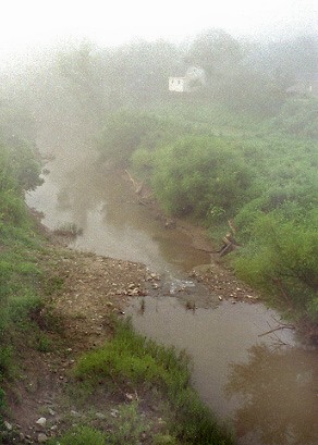
The Pocatalico River is a tributary of the Kanawha River, approximately 75 miles (121 km) long, in west-central West Virginia in the United States. Via the Kanawha and Ohio rivers, it is part of the watershed of the Mississippi River.
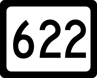
West Virginia Route 622 is a north–south state highway located entirely in Kanawha County, West Virginia. The southern terminus of the route is at West Virginia Route 25 west of Institute. The northern terminus is at Interstate 77 exit 114 north of Pocatalico.
Looneyville is an unincorporated community on Flat Creek of the Pocatalico River in Roane County, West Virginia, United States. It is located on West Virginia Route 36. The community is named for Robert Looney, a pioneer settler. The post office was established in 1870.
Raymond City is an unincorporated community in Putnam County, West Virginia, United States.

Chelyan is a census-designated place (CDP) in Kanawha County, West Virginia, United States. Chelyan is located on the south bank of the Kanawha River, southeast of Chesapeake. It is served by Exit 85 of the West Virginia Turnpike. As of the 2010 census, its population was 776.
Second Creek may refer to:
Kanawha Head is an unincorporated community in Upshur County, West Virginia, United States. Kanawha Head is located on West Virginia Route 20, 16.5 miles (26.6 km) south-southwest of Buckhannon. Kanawha Head had a post office with ZIP code 26228.
Boomer is a census-designated place (CDP) in Fayette County, West Virginia, United States. Boomer is located on the north bank of the Kanawha River, 2 miles (3.2 km) southeast of Smithers. Boomer has a post office with ZIP code 25031. As of the 2010 census, its population was 615.
Dickinson, also known as Quincy, is an unincorporated community in Kanawha County, West Virginia, United States. Dickinson is located on the north bank of the Kanawha River, 3 miles (4.8 km) southeast of Belle. The community is served by U.S. Route 60.
Paint Creek is a 42.1-mile (67.8 km) tributary of the Kanawha River in southern West Virginia. Paint Creek is part of the Mississippi River watershed via the Kanawha and Ohio Rivers and drains an area of 123 square miles (320 km2).
Second Creek is a stream in Kanawha County, West Virginia. It is a tributary of the Pocatalico River.
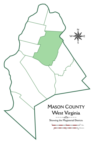
Cooper Magisterial District is one of ten magisterial districts in Mason County, West Virginia, United States. The district was originally established as a civil township in 1863, and converted into a magisterial district in 1872. In 2020, Cooper District was home to 1,700 people.

Ripley District, formerly Ripley Magisterial District, is one of five historic magisterial districts in Jackson County, West Virginia, United States. The district was originally known as Mill Creek Township, one of five civil townships established in Jackson County after West Virginia became a state in 1863; it was renamed "Ripley Township" after its chief town in 1871, and the following year, all of West Virginia's townships were converted into magisterial districts. When Jackson County was redistricted in the 1990s, the area of Ripley District was divided between the new Eastern and Western Magisterial Districts. However, the county's historic magisterial districts continue to exist in the form of tax districts, serving all of their former administrative functions except for the election of county officials.

Washington District, formerly Washington Magisterial District, is one of five historic magisterial districts in Jackson County, West Virginia, United States. The district was originally established as one of five civil townships in Jackson County after West Virginia became a state in 1863; in 1872, all of West Virginia's townships were converted into magisterial districts. When Jackson County was redistricted in the 1990s, Washington District was combined with the eastern portion of Ripley District, including the city of Ripley, to form the new Eastern Magisterial District. However, the county's historic magisterial districts continue to exist in the form of tax districts, serving all of their former administrative functions except for the election of county officials.


