
Charleston is the capital and most populous city of the U.S. state of West Virginia and the seat of Kanawha County. Located at the confluence of the Elk and Kanawha rivers, the city had a population of 48,864 at the 2020 census and an estimated population of 48,018 in 2021. The Charleston metropolitan area as a whole had an estimated 255,020 residents in 2021. Owing to its population, it is the least populous state capital to be the most populous city in a state and the second least populous to be the most populous in its state overall, behind Burlington, Vermont.

Kanawha County is a county in the U.S. state of West Virginia. As of the 2020 census, the population was 180,745, making it West Virginia's most populous county. The county seat is Charleston, which is also the state capital. Kanawha County is part of the Charleston, WV Metropolitan Statistical Area.

The Kanawha River is a tributary of the Ohio River, approximately 97 mi (156 km) long, in the U.S. state of West Virginia. The largest inland waterway in West Virginia, its watershed has been a significant industrial region of the state since early in the 19th century.

The Little Kanawha River is a tributary of the Ohio River, 169 mi (269 km) long, in western West Virginia in the United States. Via the Ohio, it is part of the watershed of the Mississippi River, draining an area of 2,320 mi² (6,009 km²) on the unglaciated portion of the Allegheny Plateau. It served as an important commercial water route in the early history of West Virginia, particularly in the logging and petroleum industries.

The James River and Kanawha Canal was a partially built canal in Virginia intended to facilitate shipments of passengers and freight by water between the western counties of Virginia and the coast. Ultimately its towpath became the roadbed for a rail line following the same course.

The Elk River is a tributary of the Kanawha River, 172 miles (277 km) long, in central West Virginia in the United States. Via the Kanawha and Ohio rivers, it is part of the watershed of the Mississippi River.

The Moneton were a historical Native American tribe from West Virginia. In the late seventeenth century they lived in the Kanawha Valley, near the Kanawha and New Rivers.
Bream is an unincorporated community along Indian Creek Rd in Kanawha County, West Virginia, United States. It is the first community after State Route 114 turns across the Elk River to Big Chimney. Bream is located between Milliken and Pinch, and is usually omitted from the map, because of its size.
Swiss is an unincorporated community in western Nicholas County, West Virginia, United States. Its elevation is 735 ft (224 m).
The Prehistory of West Virginia spans ancient times until the arrival of Europeans in the early 17th century. Hunters ventured into West Virginia's mountain valleys and made temporary camp villages since the Archaic period in the Americas. Many ancient human-made earthen mounds from various mound builder cultures survive, especially in the areas of Moundsville, South Charleston, and Romney. The artifacts uncovered in these areas give evidence of a village society with a tribal trade system culture that included limited cold worked copper. As of 2009, over 12,500 archaeological sites have been documented in West Virginia.

Waterways in West Virginia find their highest sources in the highland watersheds of the Allegheny Mountains. These watersheds supply drainage to the creeks often passing through deep and narrow hollows. From the hollows, rushing highland streams collect in bottom land brooks and rivers. People have lived along and boated on the waterways of what is now the Mountain State from the time of antiquity.
Falling Rock is an unincorporated community in Kanawha County, West Virginia, United States. Falling Rock is located at the confluence of Falling Rock Creek with the Elk River 3 miles (4.8 km) southwest of Clendenin along US Route 19. Falling Rock has a post office with ZIP code 25079.

The protohistoric period of the state of West Virginia in the United States began in the mid-sixteenth century with the arrival of European trade goods. Explorers and colonists brought these goods to the eastern and southern coasts of North America and were brought inland by native trade routes. This was a period characterized by increased intertribal strife, rapid population decline, the abandonment of traditional life styles, and the extinction and migrations of many Native American groups.

Twomile Creek is a tributary of the Kanawha River, 4.7 miles (7.6 km) long, in West Virginia in the United States. Via the Kanawha and Ohio rivers, it is part of the watershed of the Mississippi River, draining an area of 24.4 square miles (63 km2) on the unglaciated portion of the Allegheny Plateau, in the city of Charleston and its vicinity.
Cooper Magisterial District is one of ten magisterial districts in Mason County, West Virginia, United States. The district was originally established as a civil township in 1863, and converted into a magisterial district in 1872. In 2020, Cooper District was home to 1,700 people.

Lewis Magisterial District is one of ten magisterial districts in Mason County, West Virginia, United States. The district was originally established as a civil township in 1863, and converted into a magisterial district in 1872. In 2020, Robinson District was home to 5,635 people.

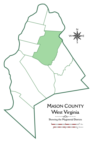
Union Magisterial District is one of ten magisterial districts in Mason County, West Virginia, United States. The district was originally established as a civil township in 1863, and converted into a magisterial district in 1872. In 2020, Union District was home to 1,261 people.

Washington District, formerly Washington Magisterial District, is one of five historic magisterial districts in Jackson County, West Virginia, United States. The district was originally established as one of five civil townships in Jackson County after West Virginia became a state in 1863; in 1872, all of West Virginia's townships were converted into magisterial districts. When Jackson County was redistricted in the 1990s, Washington District was combined with the eastern portion of Ripley District, including the city of Ripley, to form the new Eastern Magisterial District. However, the county's historic magisterial districts continue to exist in the form of tax districts, serving all of their former administrative functions except for the election of county officials.

The Eastern Magisterial District is one of three magisterial districts in Jackson County, West Virginia, United States. It was established during a process of redistricting undertaken in the 1990s. In 2010, 9,882 people lived in the district.


