
Charleston is the capital and most populous city of West Virginia. Located at the confluence of the Elk and Kanawha rivers, the city had a population of 48,864 at the 2020 census and an estimated population of 48,018 in 2021. The Charleston metropolitan area as a whole had an estimated 255,020 residents in 2021. Charleston is the center of government, commerce, and industry for Kanawha County, of which it is the county seat.

Interstate 81 (I-81) is a north–south Interstate Highway in the eastern part of the United States. Its southern terminus is at I-40 in Dandridge, Tennessee; its northern terminus is on Wellesley Island at the Canadian border, where the Thousand Islands Bridge connects it to Highway 401, the main Ontario freeway connecting Detroit via Toronto to Montreal. The major metropolitan areas that I-81 connects to include the Tri-Cities of Tennessee, Roanoke in Virginia, Harrisburg and the Wyoming Valley in Pennsylvania, and Syracuse in New York.
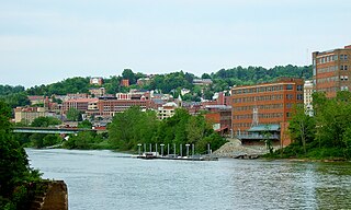
Morgantown is a city in and the county seat of Monongalia County, West Virginia, United States, situated along the Monongahela River. The largest city in North-Central West Virginia, Morgantown is best known as the home of West Virginia University. The population was 30,712 at the 2020 census. The city serves as the anchor of the Morgantown metropolitan area, which had a population of 138,176 in 2020.

Washington is a census-designated place (CDP) in Wood County, West Virginia, United States, situated along the Ohio River. It is part of the Parkersburg-Marietta-Vienna, WV-OH Metropolitan Statistical Area. The population was 1,175 at the 2010 census. The community was named after George Washington.

Dupont Circle is a traffic circle, park, neighborhood and historic district in Northwest Washington, D.C. The Dupont Circle neighborhood is bounded approximately by 16th Street NW to the east, 22nd Street NW to the west, M Street NW to the south, and Florida Avenue NW to the north. Much of the neighborhood is listed on the National Register of Historic Places. However, the local government Advisory Neighborhood Commission and the Dupont Circle Historic District have slightly different boundaries.

Samuel Francis Du Pont was a rear admiral in the United States Navy, and a member of the prominent Du Pont family. In the Mexican–American War, Du Pont captured San Diego, and was made commander of the California naval blockade. Through the 1850s, he promoted engineering studies at the United States Naval Academy, to enable more mobile and aggressive operations. In the American Civil War, he played a major role in making the Union blockade effective, but was controversially blamed for the failed attack on Charleston, South Carolina in April 1863.

Southeast is the southeastern quadrant of Washington, D.C., the capital of the United States, and is located south of East Capitol Street and east of South Capitol Street. It includes the Capitol Hill and Anacostia neighborhoods, the Navy Yard, the Joint Base Anacostia-Bolling (JBAB), the U.S. Marine Barracks, the Anacostia River waterfront, Eastern Market, the remains of several Civil War-era forts, historic St. Elizabeths Hospital, RFK Stadium, Nationals Park, and the Congressional Cemetery. It also contains a landmark known as "The Big Chair," located on Martin Luther King Jr. Avenue. The quadrant is split by the Anacostia River, with the portion that is west of the river sometimes referred to as "Near Southeast". Geographically, it is the second-smallest quadrant of the city.
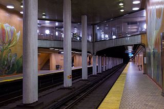
Dupont is a subway station on Line 1 Yonge–University in Toronto, Ontario, Canada. It is located on Spadina Road at Dupont Street in The Annex neighbourhood of the city. Wi-Fi service is available at this station.

The Battle of Bailén was fought in 1808 between the Spanish Army of Andalusia, led by Generals Francisco Castaños and Theodor von Reding, and the Imperial French Army's II corps d'observation de la Gironde under General Pierre Dupont de l'Étang. This battle was the first open-field defeat of a Napoleonic army. The heaviest fighting took place near Bailén, a village by the Guadalquivir river in the Jaén province of southern Spain.

The Los Gatos Creek Trail is a 9.7-mile (15.6 km) pedestrian and bicycle trail that runs through western Santa Clara County in California, from Lexington Reservoir in Los Gatos, California through Campbell, California to Meridian Avenue in San Jose, California alongside Los Gatos Creek. The trail is heavily used.

Massachusetts Avenue is a major diagonal transverse road in Washington, D.C., and the Massachusetts Avenue Historic District is a historic district that includes part of it.
Helmer Swenholt was born in Wittenberg, Shawano County, Wisconsin. Having pursued a degree in engineering, he put his education to work in the Army Corps of Engineers. He was an officer and Veteran of World War I, and after the war continued his service in the Army Corps of Engineers. In World War II, Swenholt organized one of the first of the Engineer Regiments, a new type of combat engineer organization. At the war's conclusion Swenholt returned to the United States and retired from the Army.
Riverside High School is the largest high school in Kanawha County, and is located in Belle, West Virginia, United States.

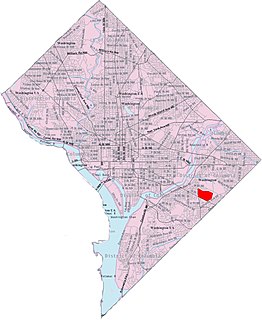
Fort Dupont is a residential neighborhood located in southeast Washington, D.C., east of the Anacostia River. It is bounded by East Capitol Street to the north, Fort Dupont Park to the south, Minnesota Avenue to the west, and Fort Chaplin Park to the east and northeast. Fort Dupont has a population of approximately 7,050.

Miss USA 2000 was the 49th Miss USA pageant, held at The Grand Palace, in Branson, Missouri on February 4, 2000. At the conclusion of the final competition, Lynnette Cole of Tennessee was crowned by outgoing titleholder Kimberly Pressler of New York.
Penn Branch is a neighborhood in Southeast Washington, D.C., east of the Anacostia River. It is bounded by Pennsylvania Avenue SE to the south; Pope Branch Park and Pope Creek to the north; Branch Avenue to the west; and Fort Davis Park to the east. ‘Penn Branch’, takes its name from its location at the intersection of two major thoroughfares, Pennsylvania and Branch Avenue.
The Dupont Circle Fountain, formally known as the Rear Admiral Samuel Francis Dupont Memorial Fountain, is a fountain located in the center of Dupont Circle in Washington, D.C. It honors Rear Admiral Samuel Francis Du Pont, a prominent American naval officer and member of the Du Pont family. The fountain replaced a statue of Du Pont that was installed in 1884. Designed by Henry Bacon and sculpted by Daniel Chester French, the fountain was dedicated in 1921. Prominent guests at the dedication ceremony included First Lady Florence Harding, Secretary of War John W. Weeks and Secretary of the Navy Edwin Denby.
Edgecomb, also known as Parklane, is a neighborhood in the North District of Baltimore, located between the neighborhoods of Cylburn (north) and Greenspring (south). Its boundaries are marked by Dupont Avenue (north), Coldspring Lane (south), Pimlico Road (west) and Greenspring Avenue (east). Central Park Heights, is located on the opposite side of Pimlico Road in the Northwest District. The neighborhood of Coldspring is located to Edgecomb's east, across Greenspring Avenue.
DuPont High School was a public high school in Dupont City, West Virginia, about 5 miles from Charleston. Built in 1961 and opened in 1962 it remained the home of the Panthers until closing in 1999 to consolidate with nearby East Bank High forming Riverside High School.


