Berkeley County is located in the Shenandoah Valley in the Eastern Panhandle region of West Virginia in the United States. The county is part of the Hagerstown-Martinsburg, MD-WV Metropolitan Statistical Area.
Belle Haven is a census-designated place (CDP) in Fairfax County, Virginia, United States. Nearby CDPs are Huntington (northwest), Groveton (southwest) and Fort Hunt (south). The population of Belle Haven was 6,518 at the 2010 census.

Martinsburg is a city in and the county seat of Berkeley County, West Virginia, United States, in the tip of the state's Eastern Panhandle region in the lower Shenandoah Valley. Its population was 17,687 in the 2016 census estimate, making it the largest city in the Eastern Panhandle and the ninth-largest municipality in the state. Martinsburg is part of the Hagerstown-Martinsburg, MD-WV Metropolitan Statistical Area.

Belle is a town in Kanawha County, West Virginia, along the Kanawha River. The population was 1,260 at the 2010 census. Belle was incorporated on December 13, 1958 by the Kanawha County Circuit Court. It is the home of the Belle Bulldogs Elementary School.

The Shenandoah Valley is a geographic valley and cultural region of western Virginia and the Eastern Panhandle of West Virginia in the United States. The valley is bounded to the east by the Blue Ridge Mountains, to the west by the eastern front of the Ridge-and-Valley Appalachians, to the north by the Potomac River and to the south by the James River. The cultural region covers a larger area that includes all of the valley plus the Virginia highlands to the west, and the Roanoke Valley to the south. It is physiographically located within the Ridge and Valley province and is a portion of the Great Appalachian Valley.

Isabella Maria Boyd, best known as Belle Boyd, was a Confederate spy in the American Civil War. She operated from her father's hotel in Front Royal, Virginia, and provided valuable information to Confederate General Stonewall Jackson in 1862.

The West Virginia House of Delegates is the lower house of the West Virginia Legislature. Only three states—Maryland, Virginia and West Virginia—refer to their lower house as the House of Delegates.
The West Virginia Legislature is the state legislature of the U.S. state of West Virginia. A bicameral legislative body, the Legislature is split between the upper Senate and the lower House of Delegates. It was established under Article VI of the West Virginia Constitution following the state's split from Virginia during the American Civil War in 1863. As with its neighbor and former constituent Virginia General Assembly, the legislature's lower house is also referred to as a "House of Delegates."
The Battle of Buffington Island, also known as the St. Georges Creek Skirmish, was an American Civil War engagement in Meigs County, Ohio, and Jackson County, West Virginia, on July 19, 1863, during Morgan's Raid. The largest battle in Ohio during the war, Buffington Island contributed to the capture of the famed Confederate cavalry raider, Brig. Gen. John Hunt Morgan, who was seeking to escape Union army pursuers across the Ohio River at a ford opposite Buffington Island.

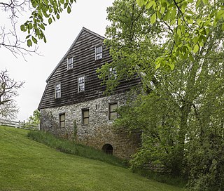
Cedar Creek and Belle Grove National Historical Park became the 388th unit of the United States National Park Service when it was authorized on December 19, 2002. The National Historical Park was created to protect several historically significant locations in the Shenandoah Valley of Northern Virginia, notably the site of the American Civil War Battle of Cedar Creek and the Belle Grove Plantation.

State Route 178 is a primary state highway in the U.S. state of Virginia. The state highway runs 11.51 miles (18.52 km) from U.S. Route 13 Business in Exmore north to SR 620, SR 628, and SR 718 at Bobtown. SR 178 connects Exmore in far northern Northampton County with Belle Haven and Pungoteague in southern Accomack County.

The West Virginia Wildfire is a women's American football team in the Women's Spring Football League since 2011. The first women's football team in West Virginia, the Wildfire is based in the city of Belle.

The Virginia Belles is the University of Virginia's oldest all-female a cappella group based in Charlottesville, Virginia. The group was established in 1977 by Katherine Mitchell as the female counterpart to the Virginia Gentlemen, the university's oldest a cappella group. Completely student-run, the Belles continue to perform an eclectic range of vocal music from oldies and classic rock to indie and R&B. They sing in and around Charlottesville, and up and down the East Coast and all across the U.S., and have received awards and honors from internationally acclaimed organizations such as the Contemporary A Cappella Society, Varsity Vocals, and the Recorded A Cappella Review Board.

Diamond is an unincorporated community in Kanawha County, West Virginia, United States. Diamond is located on the north bank of the Kanawha River 1.5 miles (2.4 km) southeast of Belle. The community is served by U.S. Route 60.
Dickinson, also known as Quincy, is an unincorporated community in Kanawha County, West Virginia, United States. Dickinson is located on the north bank of the Kanawha River 3 miles (4.8 km) southeast of Belle. The community is served by U.S. Route 60.
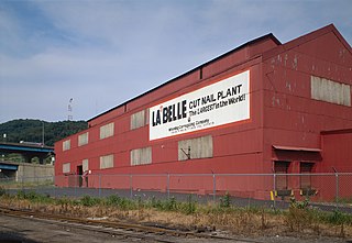
La Belle Iron Works, also known as La Belle Cut Nail Works, is a historic factory complex and national historic district located at Wheeling, Ohio County, West Virginia. The district includes four contributing buildings; three Italianate style brick buildings dated to the founding of the company in 1852, and a tin plate mill built 1894-1897. After 1902, the buildings were combined under a single roof, although the truss systems date to different periods achieving the configuration visible today. When listed in 1997, it was known as the "La Belle Cut Nail Plant, The Largest in the World, Wheeling Corrugating Company, A Division of Wheeling Pittsburgh Steel Corporation." The cut nail machinery still in use by La Belle dates to 1852 and the 1860s. The machinery at La Belle along with the different processes were documented by the Historic American Buildings Survey team during the summer of 1990.


