
Raleigh County is a county in the U.S. state of West Virginia. As of the 2010 census, the population was 78,859. Its county seat is Beckley. The county was founded in 1850 and is named for Sir Walter Raleigh. Raleigh County is included in the Beckley, West Virginia Metropolitan Statistical Area.

Alum Creek is a census-designated place (CDP) in Kanawha and Lincoln counties along the Coal River in the U.S. state of West Virginia. It includes the unincorporated communities of Alum Creek, Forks of Coal, and Priestley. The CDP had a population of 1,749 at the 2010 census, down from 1,839 at the 2000 census.

The Monongahela River —often referred to locally as the Mon —is a 130-mile-long (210 km) river on the Allegheny Plateau in north-central West Virginia and southwestern Pennsylvania. The river flows from the confluence of its west and east forks in north-central West Virginia northeasterly into southwestern Pennsylvania, then northerly to Pittsburgh and its confluence with the Allegheny River to form the Ohio River. The river's entire length is navigable via a series of locks and dams.

The Big Sandy River is a tributary of the Ohio River, approximately 29 miles (47 km) long, in western West Virginia and northeastern Kentucky in the United States. The river forms part of the boundary between the two states along its entire course. Via the Ohio River, it is part of the Mississippi River watershed.

The Elk River is a tributary of the Kanawha River, 172 miles (277 km) long, in central West Virginia in the United States. Via the Kanawha and Ohio rivers, it is part of the watershed of the Mississippi River.

Blair is an unincorporated community in Logan County, West Virginia, United States, on the Spruce Fork. Blair lies along West Virginia Route 17. According to the Geographic Names Information System, Blair has also been known as Ginseg, Ginseng, and Seng.
Pageton is a census-designated place (CDP) in McDowell County, West Virginia. As of the 2010 census, its population was 187. Pageton is located on the Tug Fork Branch of the Norfolk and Western Railway, along the Pocahontas seam of rich bituminous coal. Pageton is located on State Route 161 between Thorpe and Anawalt.
Gilliam is an unincorporated community on the North Fork River in McDowell County, West Virginia, United States. It lies between Algoma and Rolfe along County Route 17.
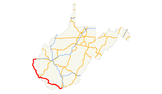
U.S. Route 52 (US 52) skirts the western fringes of the U.S. state of West Virginia. It runs from the Virginia state line near Bluefield, where it is concurrent with Interstate 77 (I-77), in a general northwest and north direction to I-64 at Kenova. There it turns east, overlapping I-64 for five miles (8.0 km) before splitting off onto the West Huntington Expressway into Ohio via the West Huntington Bridge. Despite having an even number, US 52 is signed north–south in West Virginia. In some other states along its route, it is signed east-west. The West Virginia segment is signed such that US 52 north corresponds to the general westward direction of the highway, and vice versa. For a while, US 52 parallels US 23, which is on the other side of the Big Sandy River in Kentucky. This continues into Ohio, where US 52 travels on the Ohio side of the Ohio River while US 23 travels on the Kentucky side.
Coketon is an unincorporated community and coal town in Tucker County, West Virginia, United States. Coketon lies at the confluence of Snyder Run and the North Fork Blackwater River south of the town of Thomas.
Beards Fork is a census-designated place (CDP) and coal town in Fayette County, West Virginia, United States that was founded as a coal town. As of the 2010 census, its population was 199.

Artie is an unincorporated community in Raleigh County, West Virginia, United States. Artie is 5.5 miles (8.9 km) west-northwest of Pax. Artie had a post office, which opened on October 5, 1903, and closed on February 1, 1997.

Ethel is an unincorporated community in Logan County, West Virginia, United States. Ethel is located on West Virginia Route 17 4.5 miles (7.2 km) east-northeast of Logan. Ethel has a post office with ZIP code 25076.
Glen Falls is an unincorporated community in Harrison County, West Virginia, United States. Glen Falls is located on the West Fork River 2 miles (3.2 km) north of Clarksburg.

Dante is a census-designated place in Russell and Dickenson counties, Virginia, in the United States. The population as of the 2010 Census was 649.

Shively is an unincorporated community located on the Smokehouse Fork of Big Harts Creek in Logan County, West Virginia. Shively is accessed by County Route 3. It is situated 7.2 miles from Harts and 9.3 miles from Chapmanville.
Devils Fork was an unincorporated community located in both Wyoming County and Raleigh County, West Virginia. Part of it was renamed Stephenson, West Virginia. The area's coal mines and a portion of its community resided in the vicinity of Amigo, West Virginia in Raleigh County, West Virginia.
Acup was an unincorporated community in Kanawha County, West Virginia. It was a camp of the Middle Fork Block Coal Company, which operated in the early 20th century.
Lick Fork is an unincorporated community and coal town in Fayette County, West Virginia.


