The Ohio River is a 981-mile (1,579 km) long river in the United States. It is located at the boundary of the Midwestern and Southern United States, flowing southwesterly from far-western Pennsylvania to its mouth on the Mississippi River at the southern tip of Illinois. It is the third largest river by discharge volume in the United States and the largest tributary by volume of the north-south flowing Mississippi River that divides the eastern from western United States. It is also the 6th oldest river on the North American continent. The river flows through or along the border of six states, and its drainage basin includes parts of 14 states. Through its largest tributary, the Tennessee River, the basin includes several states of the southeastern U.S. It is the source of drinking water for five million people.

The Potomac River drains the Mid-Atlantic United States, flowing from the Potomac Highlands into Chesapeake Bay. It is 405 miles (652 km) long, with a drainage area of 14,700 square miles (38,000 km2), and is the fourth-largest river along the East Coast of the United States and the 21st-largest in the United States. Over 5 million people live within its watershed. There is a hydroelectric plant along the Potomac river constructed in 2014 by Dominion.

Falls Church is an independent city in the Commonwealth of Virginia. As of the 2020 census, the population was 14,658. Falls Church is included in the Washington metropolitan area.

Fairfax County, officially the County of Fairfax, is located in the Commonwealth of Virginia in the United States. Part of Northern Virginia, Fairfax County borders both the City of Alexandria and Arlington County and forms part of the suburban ring of Washington, D.C. The county is thus predominantly suburban in character, with some urban and rural pockets.
A fall line is the area where an upland region and a coastal plain meet and is typically prominent where rivers cross it, with resulting rapids or waterfalls. The uplands are relatively hard crystalline basement rock, and the coastal plain is softer sedimentary rock. A fall line often will recede upstream as the river cuts out the uphill dense material, forming "c"-shaped waterfalls and exposing bedrock shoals. Because of these features, riverboats typically cannot travel any farther inland without portaging, unless locks are built. The rapid change in elevation of the water and resulting energy release make the fall line a good location for water mills, grist mills, and sawmills. Seeking a head of navigation with a ready supply of water power, people have long made settlements where rivers cross a fall line.

The Potomac Company was created in 1785 to make improvements to the Potomac River and improve its navigability for commerce. The project is perhaps the first conceptual seed planted in the minds of the new American capitalists in what became a flurry of transportation infrastructure projects, most privately funded, that drove wagon road turnpikes, navigations, and canals, and then as the technology developed, investment funds for railroads across the rough country of the Appalachian Mountains. In a few decades, the eastern seaboard was crisscrossed by private turnpikes and canals were being built from Massachusetts to Illinois ushering in the brief seven decades of the American Canal Age. The Potomac Company's achievement was not just to be an early example, but of being significant also in size and scope of the project, which involved taming a mountain stream fed river with icing conditions and unpredictable freshets (floods).

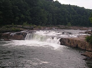
Tornado, also called Upper Falls, is a census-designated place (CDP) in Kanawha County, West Virginia, United States.

The Allegheny Mountain Range, informally the Alleghenies, is part of the vast Appalachian Mountain Range of the Eastern United States and Canada and posed a significant barrier to land travel in less developed eras. The Allegheny Mountains have a northeast–southwest orientation, running for about 400 miles (640 km) from north-central Pennsylvania, southward through western Maryland and eastern West Virginia.

The Orange Line is a rapid transit line of the Washington Metro system, consisting of 26 stations in Fairfax County and Arlington, Virginia; the District of Columbia; and Prince George's County, Maryland, United States. The Orange Line runs from Vienna in Virginia to New Carrollton in Maryland. Half of the line's stations are shared with the Blue Line and over two thirds are shared with the Silver Line. Orange Line service began on November 20, 1978.

West Falls Church is a Washington Metro station in Idylwood, Virginia on the Orange Line, the first station inside the beltway on the Orange Line going east. It is one of only two stations in the system to have three tracks, the other being the National Airport station. The center track is used for train storage, and for relaying trains to the adjacent Falls Church Yard.

The Kanawha River is a tributary of the Ohio River, approximately 97 mi (156 km) long, in the U.S. state of West Virginia. The largest inland waterway in West Virginia, its valley has been a significant industrial region of the state since early in the 19th century.

The Youghiogheny River, or the Yough for short, is a 134-mile-long (216 km) tributary of the Monongahela River in the U.S. states of West Virginia, Maryland, and Pennsylvania. It drains an area on the west side of the Allegheny Mountains northward into Pennsylvania, providing a small watershed in extreme western Maryland into the tributaries of the Mississippi River. Youghiogheny is a Lenape word meaning "a stream flowing in a contrary direction".

The National Register of Historic Places in the United States is a register including buildings, sites, structures, districts, and objects. The Register automatically includes all National Historic Landmarks as well as all historic areas administered by the U.S. National Park Service. Since its introduction in 1966, more than 90,000 separate listings have been added to the register.

The Blackwater River is a 34.3-mile-long (55.2 km) river in the Allegheny Mountains of eastern West Virginia, USA. Via the Black Fork, it is a principal tributary of the Cheat River. Via the Cheat, the Monongahela and the Ohio rivers, it is part of the watershed of the Mississippi River and drains an area of 142 square miles (370 km2). It is a true blackwater stream, owing to spruce and hemlock trees in its watershed, the tannins of which impart a tea or amber color to its water.

Blackwater Falls State Park is located in the Allegheny Mountains of Tucker County, West Virginia, US. The centerpiece of the park is Blackwater Falls, a 62-foot (19 m) cascade where the Blackwater River leaves its leisurely course in Canaan Valley and enters rugged Blackwater Canyon. It is among the most photographed venues in the state and appears on calendars, stationery, and advertisements. The river is named for its tannin-darkened water.

Valley Falls State Park is a 1,145 acre (4.63 km²) day use facility sited along both banks of the Tygart Valley River. The park is located about 7 miles (11 km) south of exit 137 of I-79, near Fairmont, West Virginia.

The Elakala Falls are a series of four waterfalls of Shays Run as it descends into the Blackwater Canyon in West Virginia. They are within Blackwater Falls State Park and are quite popular among photographers, with the ease of access for the first waterfall, and the relatively low traffic of the other waterfalls in the series. The first of the series of waterfalls is 35 feet (11 m) in height and is easily accessible from park trails. It is the second most popular waterfall in the park. From the official Elakala trail there is a bridge over the top of the first waterfall offering easy access and views. The remaining three waterfalls of the series are progressively more difficult to access, and have no official marked trails to them. The gorge is nearly 200 feet deep at this section accounting for the difficulty of the descent to the lower waterfalls of the series.

The Atlantic Seaboard Fall Line, or Fall Zone, is a 900-mile (1,400 km) escarpment where the Piedmont and Atlantic coastal plain meet in the eastern United States. Much of the Atlantic Seaboard fall line passes through areas where no evidence of faulting is present.
Ferrell is an unincorporated area in Kanawha County, West Virginia, United States.
River Bend is an unincorporated area in Kanawha County, West Virginia, United States.


