
West Virginia is a state in the Appalachian, Mid-Atlantic and Southeastern regions of the United States. It is bordered by Pennsylvania to the northeast, Maryland to the east and northeast, Virginia to the southeast, Kentucky to the southwest, and Ohio to the northwest. West Virginia is the 41st-largest state by area and ranks 38th in population, with a population of 1,795,045 residents. The capital and largest city is Charleston.

Kanawha County is a county in the U.S. state of West Virginia. As of the 2019 American Community Survey, the population was 183,279. This was a decrease of 9,784 since the 2010 Census; nevertheless, it is West Virginia's most populous county. The county seat is Charleston, which is also the state capital. Kanawha County is part of the Charleston, WV Metropolitan Statistical Area.

Bolton is a town in Warren County, New York, United States. It is part of the Glens Falls Metropolitan Statistical Area. The population was 2,117 at the 2000 census. Bolton is on the east border of the county.
The Pigg River is a river in south-central Virginia in the United States. It is a tributary of the Roanoke River, which flows to the Atlantic Ocean via Albemarle Sound.

The Five Mile River is a 10.1-mile-long (16.3 km) river in central Massachusetts, part of the Chicopee River watershed. It rises north of Dean Pond in the Town of Oakham within Rutland State Forest and flows south through Dean Pond to Brooks Pond, 2.5 miles (4.0 km) northeast of North Brookfield, then continues south to its mouth at the north end of Lake Lashaway, also in North Brookfield.
Englewood Township is a township in Clark County, Kansas, USA. As of the 2000 census, its population was 171.
State Route 73 (SR-73) is a 36.147-mile-long (58.173 km) state highway in the U.S. state of Utah, connecting the Rush and Utah Valleys. It is a discontinuous route in two segments; one long segment connecting SR-36 to Saratoga Springs, and one short segment within the city of Lehi.

The Sacaton Mountains are a range of granitic inselbergs in Pinal County, Arizona, located south of Phoenix near Casa Grande, Arizona.
Fivemile Rock is a small nunatak, 375 metres (1,230 ft) high, rising just northwest of Mineral Hill on Tabarin Peninsula, Antarctica. It was mapped in 1946 and again in 1956 by the Falkland Islands Dependencies Survey, and so named because the feature is located 5 nautical miles (9 km) from their station at Hope Bay on the route from there to Duse Bay.
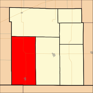
Campbells Creek is a tributary of the Kanawha River, 18.5 miles (29.8 km) long, in West Virginia in the United States. Via the Kanawha and Ohio rivers, it is part of the watershed of the Mississippi River, draining an area of 39.3 square miles (102 km2) on the unglaciated portion of the Allegheny Plateau, in the Charleston metropolitan area.
Fivemile Corner is an unincorporated community in Cotton County, Oklahoma, United States. The elevation is 1,063 feet. Fivemile Corner is located at 34°21′44″N98°13′35″W.

Tahkenitch Lake, at 2,118 acres (857 ha), is one of the larger lakes along the coast of the U.S. state of Oregon. Fed by runoff from a basin of about 34 square miles (88 km2), it lies east of U.S. Route 101 in Douglas County between Florence and Reedsport. Its name comes from a Lower Umpqua (Siuslaw) placename meaning "having arms running out like a crab".
Five Mile Creek is an Australian television series.
Fivemile Crossing is an unincorporated community in Menard County, Texas, United States.

Arbuckle Magisterial District is one of ten magisterial districts in Mason County, West Virginia, United States. The district was originally established as a civil township in 1863, and converted into a magisterial district in 1872. In 2010, Arbuckle District was home to 1,121 people.

Clendenin Magisterial District is one of ten magisterial districts in Mason County, West Virginia, United States. The district was originally established as a civil township in 1863, and converted into a magisterial district in 1872. In 2010, Clendenin District was home to 3,715 people.

Fivemile Creek is a 4.87 mi (7.84 km) long tributary to East Branch Oil Creek in Crawford County, Pennsylvania.

Tokeneke is a census-designated place (CDP) in the town of Darien, Fairfield County, Connecticut, United States. It comprises the southeast part of the town, occupying several peninsulas and islands that extend into Long Island Sound, between the Goodwives River to the west and the Fivemile River to the east. It is bordered to the north by Darien Downtown and to the east by the city of Norwalk.
Dayville is a census-designated place (CDP) in the northwest part of the town of Killingly in Windham County, Connecticut, United States. It is located on the east side of the Fivemile River, 5 miles (8 km) north of Danielson. Interstate 395 passes through the east side of the CDP, leading south to Norwich and north to Auburn, Massachusetts.


