
The Shenandoah River is a tributary of the Potomac River, 55.6 miles (89.5 km) long with two forks approximately 100 miles (160 km) long each, in the U.S. states of Virginia and West Virginia. The principal tributary of the Potomac, the river and its tributaries drain the central and lower Shenandoah Valley and the Page Valley in the Appalachians on the west side of the Blue Ridge Mountains, in northwestern Virginia and the Eastern Panhandle of West Virginia.

The Dry Fork is a 39.1-mile-long (62.9 km) tributary of the Black Fork of the Cheat River in the Allegheny Mountains of eastern West Virginia, USA. Via the Black Fork, the Cheat, and the Monongahela and Ohio rivers, it is part of the watershed of the Mississippi River. The Dry Fork flows for much of its length in the Monongahela National Forest and drains mostly rural and forested areas. It was traditionally considered one of the five Forks of Cheat.

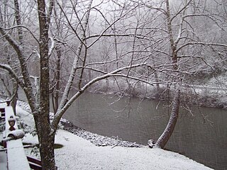
Sleepy Creek is a 44.0-mile-long (70.8 km) tributary of the Potomac River in the United States, belonging to the Chesapeake Bay's watershed. The stream rises in Frederick County, Virginia, and flows through Morgan County, West Virginia before joining the Potomac near the community of Sleepy Creek.

Beech Fork State Park is a state park located in Cabell County and Wayne County, West Virginia. The park is located on the tailwater shores of Beech Fork Lake, a flood control impoundment of the U.S. Army Corps of Engineers on the Beech Fork of Twelvepole Creek. Since its development in the mid-1970s, Beech Fork State Park has proven to be a popular recreation spot for the residents of nearby Barboursville and Huntington, West Virginia, as well as those living in the surrounding region. The park is located about 10 miles (16 km) south of the Hal Greer Exit of Interstate 64.

State Route 61 is a primary state highway in the U.S. state of Virginia. The state highway runs 48.16 miles (77.51 km) from SR 16 in Tazewell east to U.S. Route 460 in Narrows. SR 61 passes through several narrow creek valleys as it parallels the West Virginia state line through Tazewell, Bland, and Giles counties. The only sizeable community between the highway's endpoints is Rocky Gap, where the highway meets US 52 and Interstate 77 (I-77).

State Route 153 is a primary state highway in the U.S. state of Virginia. The state highway runs 17.15 miles (27.60 km) from U.S. Route 460 near Blackstone north to US 360 near Winterham. SR 153 is the primary north–south highway of eastern Amelia County. The state highway also provides a connection between Blackstone and Richmond in conjunction with US 360.
Rocky Gap is an unincorporated community that is located in Bland County in the U.S. state of Virginia. In the year of 2016, there was an estimate that there were a total of 511 people living in Rocky Gap. Rocky Gap has one zip code (24366).

North Fork Mountain is a quartzite-capped mountain ridge in the Ridge and Valley physiographic province of the Allegheny Mountains of eastern West Virginia, USA. Kile Knob, at 4,588 feet, is the mountain's highest point, and Panther Knob and Pike Knob are nearly as high.
Elk Pond Mountain is a peak of the Blue Ridge Mountains, on the border of Nelson and Rockbridge counties in Virginia. Elk Pond Mountain is flanked to the east by Maintop Mountain, and to the southwest by Rocky Mountain.

Dunkard Fork Wildlife Management Area is located on 470 acres (190 ha) in Marshall County near Moundsville, West Virginia. Mixed hardwoods cover most of the former Jacob Crow (1815-1901) (later C.C. Mooney [d. 1970] farm, site, whose major focus is a flood control lake on Dunkard Fork Wheeling Creek. The rolling terrain is punctuated with a few highwalls and ponds. Dunkard Fork WMA is located in northeast Marshall County along the Pennsylvania line on County Route 15. Construction of the dam was originally slated for a location upstream, but was later moved into West Virginia. Construction was underway by 1991 and the Jacob Crow farm was ruined. Archeological digs were conducted and photographs taken to document the site before the structures were razed.

Tug Fork Wildlife Management Area (WMA) is located about 10 miles northwest of Welch, West Virginia in McDowell County. Tug Fork WMA is located on 2,165 acres (876 ha) of steep terrain along hills above the Tug Fork River. The WMA is heavily forested, primarily with mixed hardwoods and yellow poplar/black cherry forests in the coves. The WMA is accessed from U.S. Route 52 at Premier. Several tracks and jeep trails provide walking access into the Tug Fork WMA from U.S. Route 52.

Henry Fork is an unincorporated community and census-designated place (CDP) in Franklin County, Virginia, United States, just south of Rocky Mount. The population as of the 2010 census was 1,234.
Stewartstown is an unincorporated community in Monongalia County, West Virginia.
Rocky Fork Township is one of ten townships in Boone County, Missouri, USA. The city of Hallsville is the largest settlement in the township.

The Laurel Fork is a 15.7-mile-long (25.3 km) stream in Virginia and West Virginia, United States. The stream flows north from Highland County, Virginia, where its source and the majority of its length is located, to its mouth in Pendleton County, West Virginia. Laurel Fork is a tributary to the North Fork South Branch Potomac River, making it a part of the Potomac River watershed. The area surrounding Laurel Fork is home to several plant and animal species found nowhere else in Virginia, and is a prime example of a northern boreal forest in the state.


