Belington, West Virginia

Last updated

Belington, West Virginia
Logo of Belington, West Virginia.svg
Barbour County West Virginia Incorporated and Unincorporated areas Belington Highlighted.svg
Location of Belington in Barbour County, West Virginia.
Coordinates: 39°1′33″N79°56′17″W / 39.02583°N 79.93806°W / 39.02583; -79.93806
Country Flag of the United States.svg  United States
State Flag of West Virginia.svg  West Virginia
County Flag of Barbour County, West Virginia.svg Barbour
Districts Barker (Wards 1, 2)
Valley (Wards 3, 4)
Settled1766-70
Incorporated1894-08-22 [1]
Named for John Bealin
Government
  TypeMayor & City Council
  MayorCherri Sturm
Area
[2]
  Total2.13 sq mi (5.52 km2)
  Land2.06 sq mi (5.34 km2)
  Water0.07 sq mi (0.18 km2)
Elevation
[3]
1,703 ft (519 m)
Population
 (2020) [4]
  Total1,804
  Estimate 
(2021) [4]
1,803
  Density922.85/sq mi (356.24/km2)
Time zone UTC-5 (Eastern (EST))
  Summer (DST) UTC-4 (EDT)
ZIP code
26250
Area code 304
FIPS code 54-05788 [5]
GNIS feature ID1535594 [3]
Website https://cityofbelington.com/

Belington is a town in Barbour County, West Virginia, United States, situated along the Tygart Valley River. The population was 1,804 as of the 2020 census. [4]

Contents

History

Belington was founded in 1766–70. [1] Originally it was known as the Barker Settlement, after Elias Barker, who had settled there with his brother William Barker. About 1785, it was called Yeagers, taking its name from a settler, George Yeager, and his sons. In 1855, it took its current name, Belington, from John Bealin, who had opened up a store there, and who would later move to Kansas.

After the June 3, 1861 Battle of Philippi, the Confederate forces, having been routed by the Union Army in Philippi, retreated south. The Confederates made camp near the Laurel Mountain Road, today, a winding single lane dirt road that crosses the mountain and connects Belington with Elkins.

In 1891, the West Virginia Central and Pittsburg Railway (later the Western Maryland Railway) was built into Belington. In 1894 the land on the east side of the river was incorporated as Belington, while the west side was incorporated as Alston in 1897. The two towns merged in 1906 to form the present Belington. [1]

The Bernard E. Wilmoth House in Belington is a historic house listed on the National Register of Historic Places.

Geography

Belington is located at 39°1′33″N79°56′17″W / 39.02583°N 79.93806°W / 39.02583; -79.93806 (39.025706, -79.938166). [6]

The town has a total area of 2.13 square miles (5.52 km2), of which 2.06 square miles (5.34 km2) is land and 0.07 square miles (0.18 km2) is water. [7]

Demographics

Historical population
CensusPop.Note
1900 430
1910 1,481244.4%
1920 1,76619.2%
1930 1,571−11.0%
1940 1,517−3.4%
1950 1,69912.0%
1960 1,528−10.1%
1970 1,5672.6%
1980 2,03830.1%
1990 1,850−9.2%
2000 1,788−3.4%
2010 1,9217.4%
2020 1,804−6.1%
2021 (est.)1,803 [4] −0.1%
U.S. Decennial Census [8]

2010 census

As of the census [9] of 2010, there were 1,921 people, 776 households, and 548 families living in the town. The population density was 932.5 inhabitants per square mile (360.0/km2). There were 878 housing units at an average density of 426.2 per square mile (164.6/km2). The racial makeup of the town was 98.3% White, 0.3% African American, 0.1% Asian, 0.1% Pacific Islander, 0.5% from other races, and 0.8% from two or more races. Hispanic or Latino of any race were 1.0% of the population.

There were 776 households, of which 33.4% had children under the age of 18 living with them, 49.2% were married couples living together, 15.7% had a female householder with no husband present, 5.7% had a male householder with no wife present, and 29.4% were non-families. 23.6% of all households were made up of individuals, and 13.8% had someone living alone who was 65 years of age or older. The average household size was 2.48 and the average family size was 2.88.

The median age in the town was 40.9 years. 23.8% of residents were under the age of 18; 6.5% were between the ages of 18 and 24; 24.5% were from 25 to 44; 27% were from 45 to 64; and 18% were 65 years of age or older. The gender makeup of the town was 47.6% male and 52.4% female.

2000 census

As of the census [5] of 2000, there were 1,788 people, 713 households, and 518 families living in the town. The population density was 870.2 inhabitants per square mile (336.8/km2). There were 790 housing units at an average density of 384.5 per square mile (148.8/km2). The racial makeup of the town was 98.66% White, 0.06% African American, 0.17% Native American, 0.06% Asian, 0.06% Pacific Islander, and 1.01% from two or more races. Hispanic or Latino of any race were 0.67% of the population.

There were 713 households, out of which 33.7% had children under the age of 18 living with them, 54.1% were married couples living together, 14.7% had a female householder with no husband present, and 27.3% were non-families. 23.8% of all households were made up of individuals, and 11.5% had someone living alone who was 65 years of age or older. The average household size was 2.51 and the average family size was 2.95.

In the town, the population was spread out, with 26.3% under the age of 18, 7.7% from 18 to 24, 26.2% from 25 to 44, 24.0% from 45 to 64, and 15.8% who were 65 years of age or older. The median age was 38 years. For every 100 females, there were 97.4 males. For every 100 females age 18 and over, there were 89.2 males.

The median income for a household in the town was $22,154, and the median income for a family was $28,500. Males had a median income of $25,809 versus $15,050 for females. The per capita income for the town was $12,905. About 18.3% of families and 20.9% of the population were below the poverty line, including 29.9% of those under age 18 and 7.7% of those age 65 or over.

Climate

The climate in this area has mild differences between highs and lows, and there is adequate rainfall year-round. According to the Köppen Climate Classification system, Belington has a marine west coast climate, abbreviated "Cfb" on climate maps. [10]

Climate data for Belington, West Virginia(1981-2010)
MonthJanFebMarAprMayJunJulAugSepOctNovDecYear
Mean maximum °F (°C)63
(17)
66
(19)
74
(23)
82
(28)
85
(29)
88
(31)
89
(32)
89
(32)
86
(30)
79
(26)
74
(23)
64
(18)
89
(32)
Mean daily maximum °F (°C)39.0
(3.9)
42.7
(5.9)
51.5
(10.8)
62.9
(17.2)
71.1
(21.7)
78.7
(25.9)
81.8
(27.7)
80.7
(27.1)
74.7
(23.7)
64.3
(17.9)
54.2
(12.3)
42.7
(5.9)
62.0
(16.7)
Daily mean °F (°C)29.0
(−1.7)
31.3
(−0.4)
39.1
(3.9)
49.4
(9.7)
57.7
(14.3)
66.8
(19.3)
70.2
(21.2)
69.3
(20.7)
62.3
(16.8)
50.5
(10.3)
42.3
(5.7)
32.6
(0.3)
50.0
(10.0)
Mean daily minimum °F (°C)18.9
(−7.3)
19.9
(−6.7)
26.9
(−2.8)
35.4
(1.9)
44.5
(6.9)
54.7
(12.6)
58.5
(14.7)
57.5
(14.2)
49.9
(9.9)
37.2
(2.9)
30.1
(−1.1)
22.5
(−5.3)
38.0
(3.3)
Mean minimum °F (°C)−4
(−20)
−1
(−18)
10
(−12)
20
(−7)
30
(−1)
41
(5)
46
(8)
47
(8)
37
(3)
24
(−4)
15
(−9)
3
(−16)
−4
(−20)
Average precipitation inches (mm)3.27
(83)
3.44
(87)
4.47
(114)
4.27
(108)
5.32
(135)
4.94
(125)
5.12
(130)
3.67
(93)
3.98
(101)
3.06
(78)
3.58
(91)
3.87
(98)
48.99
(1,243)
Average snowfall inches (cm)16.4
(42)
13.0
(33)
5.6
(14)
1.1
(2.8)
0.0
(0.0)
0.0
(0.0)
0.0
(0.0)
0.0
(0.0)
0.0
(0.0)
0.2
(0.51)
1.9
(4.8)
8.6
(22)
46.8
(119.11)
Average extreme snow depth inches (cm)8
(20)
6
(15)
4
(10)
1
(2.5)
0
(0)
0
(0)
0
(0)
0
(0)
0
(0)
0
(0)
1
(2.5)
5
(13)
8
(20)
Average precipitation days (≥ 0.01 inches)15141414131211101091117150
Average snowy days (≥ 0.01 inches)86310000001524
Average relative humidity (%)84848179797878787980788380
Mean monthly sunshine hours 105.4115.8176.7234269.7288297.6297255170.51531242,486.7
Mean daily sunshine hours 3.44.15.77.88.79.69.69.98.55.55.146.8
Mean daily daylight hours 9.810.81213.314.314.914.613.612.411.2109.512.2
Average ultraviolet index 2224555543223
Source 1: National Weather service [11]
Source 2: Weather atlas(Humidity - Sunshine - UV) [12]

Related Research Articles

<span class="mw-page-title-main">Boligee, Alabama</span> Town in Alabama, United States

Boligee is a town in Greene County, Alabama, United States. Per the 2020 census, the population was 301. Although Boligee appeared on the 1880 U.S. Census, according to the 1930 U.S. Census it did not incorporate until 1926, though another source cited 1927.

<span class="mw-page-title-main">Detroit, Alabama</span> Town in Alabama, United States

Detroit is a town in Lamar County, Alabama, United States. It was incorporated in 1955. At the 2010 census the population was 237, down from 247 in 2000. The prior name of the town was Millville due to the many mills built in the late 1800s.

<span class="mw-page-title-main">Chatom, Alabama</span> City in and county seat of Washington County, Alabama

Chatom is a town in Washington County, Alabama, United States. It incorporated in 1949. Chatom is the county seat of Washington County, holding the distinction since 1907. The town's population was 1,288 At the 2010 census, up from 1,193 in 2000.

<span class="mw-page-title-main">Bruceville, Indiana</span> Town in Indiana, United States

Bruceville is a town in Washington Township, Knox County, Indiana, United States. The population was 478 at the 2010 census.

<span class="mw-page-title-main">Hartford, Maine</span> Town in the state of Maine, United States

Hartford is a town in Oxford County, Maine, United States. Hartford is included in the Lewiston-Auburn, Maine metropolitan New England City and Town Area. The population was 1,203 at the 2020 census.

<span class="mw-page-title-main">Preston, Maryland</span> Town in Maryland

Preston is a town in Caroline County, Maryland, United States. The population was 719 at the 2010 census.

<span class="mw-page-title-main">Marcellus, Michigan</span> Village in Michigan, United States

Marcellus is a village in Cass County in the U.S. state of Michigan. The population was 1,074 at the 2020 census. The village is located within Marcellus Township. It is part of the South Bend–Mishawaka, IN-MI, Metropolitan Statistical Area.

<span class="mw-page-title-main">Kenmare, North Dakota</span> City in North Dakota, United States

Kenmare is a city in Ward County, North Dakota, United States. The population was 961 at the 2020 census. Kenmare is part of the Minot Micropolitan Statistical Area.

<span class="mw-page-title-main">Porter Township, Jefferson County, Pennsylvania</span> Township in Pennsylvania, United States

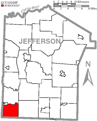
Porter Township is a township in Jefferson County, Pennsylvania, United States. The population was 294 at the 2020 census.

<span class="mw-page-title-main">Graford, Texas</span> City in Texas, United States

Graford is a town in Palo Pinto County, Texas, United States. The population was 669 at the 2020 census.

<span class="mw-page-title-main">Eatonville, Washington</span> Town in Washington, United States

Eatonville is a town in Pierce County, Washington, United States. It is 32 mi (51 km) south of Tacoma. The population was 2,845 at the 2020 census. The town motto is "Better Together".

<span class="mw-page-title-main">Albion, Washington</span> Town in Washington, United States

Albion is a town in Whitman County, Washington, United States. The population was 550 at the 2020 Census.

<span class="mw-page-title-main">Beech Bottom, West Virginia</span> Village in West Virginia, United States

Beech Bottom is a village in Brooke County, West Virginia, United States, situated along the Ohio River. The population was 523 at the 2010 census. It is part of the Weirton–Steubenville metropolitan area.

<span class="mw-page-title-main">Grantsville, West Virginia</span> Town in West Virginia, United States

Grantsville is a town in Calhoun County, West Virginia, United States. The population was 482 at the 2020 census. It is the county seat of Calhoun County. The town was established along the Little Kanawha River in 1865 and named for Ulysses S. Grant. Grantsville is home to Wayne Underwood Park, which includes a .25-mile-long (0.40 km) walking trail, and to the annual West Virginia Wood Festival.

<span class="mw-page-title-main">Bayard, West Virginia</span> Town in West Virginia, United States

Bayard is a town in Grant County, West Virginia, United States. The population was 200 at the 2020 census. Bayard was incorporated in 1893 and named in honor of Thomas F. Bayard, Jr., who later became a United States senator from Delaware (1923–1929). Bayard was founded on the West Virginia Central and Pittsburgh Railroad as a coal mining community. Coal mining has remained the town's chief industry.

<span class="mw-page-title-main">Granville, West Virginia</span> Town in West Virginia

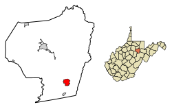
Granville is a town in Monongalia County, West Virginia, United States. The population was 1,355 at the 2020 census. It is included in the Morgantown metropolitan area.

<span class="mw-page-title-main">Terra Alta, West Virginia</span> Town in West Virginia, United States

Terra Alta is a town in eastern Preston County, West Virginia, United States. The population was 1,415 at the 2020 census. It is part of the Morgantown metropolitan area.

<span class="mw-page-title-main">Smithfield, West Virginia</span> Town in West Virginia, United States

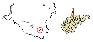
Smithfield is a town in Wetzel County, West Virginia, United States. The population was 103 at the 2020 census.

<span class="mw-page-title-main">Elizabeth, West Virginia</span> Town in West Virginia, United States

Elizabeth is a town in and the county seat of Wirt County, West Virginia, United States, situated along the Little Kanawha River. The population was 724 as of the 2020 census.

<span class="mw-page-title-main">Coulee Dam, Washington</span> Town in Washington, United States

Coulee Dam is a town in Douglas, Grant, and Okanogan counties in the state of Washington. The Douglas County portion of Coulee Dam is part of the Wenatchee–East Wenatchee Metropolitan Statistical Area. The population was 1,211 as of the 2020 census.

References

  1. 1 2 3 City of Belington, WV. "About Us." Accessed July 28, 2013.
  2. "2019 U.S. Gazetteer Files". United States Census Bureau. Retrieved August 7, 2020.
  3. 1 2 U.S. Geological Survey Geographic Names Information System: Belington, West Virginia
  4. 1 2 3 4 "City and Town Population Totals: 2020-2021". Census.gov. US Census Bureau. Retrieved July 2, 2022.
  5. 1 2 "U.S. Census website". United States Census Bureau . Retrieved January 31, 2008.
  6. "US Gazetteer files: 2010, 2000, and 1990". United States Census Bureau. February 12, 2011. Retrieved April 23, 2011.
  7. "US Gazetteer files 2010". United States Census Bureau. Archived from the original on January 25, 2012. Retrieved January 24, 2013.
  8. "Census of Population and Housing". Census.gov. Retrieved June 4, 2015.
  9. "U.S. Census website". United States Census Bureau . Retrieved January 24, 2013.
  10. Climate Summary for Belington, West Virginia
  11. "Climate". weather.gov. National Weather Service. Retrieved September 6, 2023.
  12. "Yearly & Monthly Weather - Belington, WV". weather atlas. Retrieved September 6, 2023.