Fairview, West Virginia

Last updated

Fairview, West Virginia
Marion County West Virginia Incorporated and Unincorporated areas Fairview Highlighted.svg
Location of Fairview in Marion County, West Virginia.
Coordinates: 39°35′34″N80°14′50″W / 39.59278°N 80.24722°W / 39.59278; -80.24722
Country United States
State West Virginia
County Marion
Area
[1]
  Total0.28 sq mi (0.72 km2)
  Land0.28 sq mi (0.72 km2)
  Water0.00 sq mi (0.00 km2)
Elevation
1,001 ft (305 m)
Population
 (2020) [2]
  Total374
  Estimate 
(2021) [2]
373
  Density1,442.86/sq mi (557.70/km2)
Time zone UTC-5 (Eastern (EST))
  Summer (DST) UTC-4 (EDT)
ZIP code
26570
Area code 304
FIPS code 54-26524 [3]
GNIS feature ID1538797 [4]

Fairview is a town in Marion County, West Virginia, United States. The population was 374 at the 2020 census. [2]

Contents

The town took its name from the old Fairview Inn near the original town site. [5]

Geography

Fairview is located at 39°35′34″N80°14′50″W / 39.59278°N 80.24722°W / 39.59278; -80.24722 (39.592698, -80.247124). [6]

According to the United States Census Bureau, the town has a total area of 0.28 square miles (0.73 km2), all land. [7]

Demographics

Historical population
CensusPop.Note
1860 69
1870 724.3%
1880 195170.8%
1890 23520.5%
1910 782
1920 8275.8%
1930 8361.1%
1940 831−0.6%
1950 775−6.7%
1960 653−15.7%
1970 640−2.0%
1980 75918.6%
1990 513−32.4%
2000 435−15.2%
2010 408−6.2%
2020 374−8.3%
2021 (est.)373 [2] −0.3%
U.S. Decennial Census [8]

2010 census

At the 2010 census there were 408 people, 173 households, and 117 families living in the town. The population density was 1,457.1 inhabitants per square mile (562.6/km2). There were 199 housing units at an average density of 710.7 per square mile (274.4/km2). The racial makeup of the town was 98.8% White, 0.2% Native American, and 1.0% from two or more races. Hispanic or Latino of any race were 0.2%. [9]

Of the 173 households 26.6% had children under the age of 18 living with them, 47.4% were married couples living together, 11.6% had a female householder with no husband present, 8.7% had a male householder with no wife present, and 32.4% were non-families. 28.9% of households were one person and 16.2% were one person aged 65 or older. The average household size was 2.36 and the average family size was 2.85.

The median age in the town was 45.9 years. 21.1% of residents were under the age of 18; 5.6% were between the ages of 18 and 24; 21.8% were from 25 to 44; 27.7% were from 45 to 64; and 23.8% were 65 or older. The gender makeup of the town was 48.3% male and 51.7% female.

2000 census

At the 2000 census there were 435 people, 186 households, and 125 families living in the town. The population density was 1,537.5 inhabitants per square mile (599.8/km2). There were 225 housing units at an average density of 795.3 per square mile (310.3/km2). The racial makeup of the town was 99.54% White, and 0.46% from two or more races. Hispanic or Latino of any race were 0.69%. [3]

Of the 186 households 27.4% had children under the age of 18 living with them, 50.5% were married couples living together, 14.0% had a female householder with no husband present, and 32.3% were non-families. 30.1% of households were one person and 19.4% were one person aged 65 or older. The average household size was 2.34 and the average family size was 2.87.

The age distribution was 23.7% under the age of 18, 6.9% from 18 to 24, 21.4% from 25 to 44, 26.9% from 45 to 64, and 21.1% 65 or older. The median age was 43 years. For every 100 females, there were 79.0 males. For every 100 females age 18 and over, there were 73.8 males.

The median household income was $24,896 and the median family income was $32,679. Males had a median income of $26,607 versus $14,375 for females. The per capita income for the town was $14,106. About 14.8% of families and 16.7% of the population were below the poverty line, including 31.5% of those under age 18 and 5.0% of those age 65 or over.

Notable people

See also

Related Research Articles

<span class="mw-page-title-main">Myrtlewood, Alabama</span> Town in Alabama, United States

Myrtlewood is a town in Marengo County, Alabama, United States. At the 2020 census the population was 70, down from 130 in 2010.

<span class="mw-page-title-main">Fairview, California</span> CDP in California, United States

Fairview is a census-designated place (CDP) in Alameda County, California, United States. It borders on the city of Hayward and the census-designated place of Castro Valley. The population was 11,341 at the 2020 census.

<span class="mw-page-title-main">Derby Acres, California</span> Census-designated place in California, United States

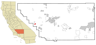
Derby Acres is a census-designated place (CDP) in Kern County, California, United States. Derby Acres is located 5.5 miles (8.9 km) north-northwest of Fellows, at an elevation of 1,375 feet (419 m). The population was 322 at the 2010 census, down from 376 at the 2000 census. The town is on State Route 33 at the northern extremity of the Midway-Sunset Oil Field, about five miles (8 km)five miles southeast of McKittrick.

<span class="mw-page-title-main">Illiopolis, Illinois</span> Village in Illinois, United States

Illiopolis is a village in Sangamon County, Illinois, United States. The population was 891 at the 2010 census. It is part of the Springfield, Illinois Metropolitan Statistical Area.

<span class="mw-page-title-main">Glenwood, Indiana</span> Town in Indiana, United States

Glenwood is a town in Union Township, Rush County and in Orange and Fairview townships, Fayette County in the U.S. state of Indiana. The population was 250 at the 2010 census.

<span class="mw-page-title-main">Fairview Park, Indiana</span> Town in Indiana, United States

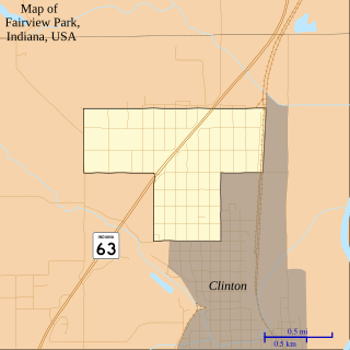
Fairview Park is a town in Clinton Township, Vermillion County, in the U.S. state of Indiana. The population was 1,386 at the 2010 census.

Talmadge is a town in Washington County, Maine, United States. The town was named after landowner Benjamin Tallmadge. The population was 70 at the 2020 census.

<span class="mw-page-title-main">Fairview, Montana</span> Town in Montana, United States

Fairview is a town in Richland County, Montana, United States. The population was 896 at the 2020 census. The town is directly on the North Dakota border. Fairview incorporated in 1913.

<span class="mw-page-title-main">Fairview, Monmouth County, New Jersey</span> Populated place in Monmouth County, New Jersey, US

Fairview is an unincorporated community and census-designated place (CDP) located within Middletown Township, in Monmouth County, in the U.S. state of New Jersey. As of the 2010 United States Census, the CDP's population was 3,806.

<span class="mw-page-title-main">Myers Corner, New York</span> Census-designated place in New York, United States

Myers Corner is a hamlet and census-designated place (CDP) in the town of Wappinger, Dutchess County, New York, United States. The population was 6,790 at the 2010 census. It is part of the Poughkeepsie–Newburgh–Middletown, NY Metropolitan Statistical Area as well as the larger New York–Newark–Bridgeport, NY-NJ-CT-PA Combined Statistical Area.

<span class="mw-page-title-main">Fairview, Westchester County, New York</span> CDP in New York, United States

Fairview is a hamlet and a census-designated place (CDP) located in the town of Greenburgh, Westchester County, New York, United States. The population was 3,099 at the 2010 census. As of 2000, Fairview had the fourth-highest percentage of African-Americans in New York.

<span class="mw-page-title-main">Meeker, Oklahoma</span> Town in Oklahoma, United States

Meeker is a town in Lincoln County, Oklahoma, United States. The population was 1,145 at the 2010 census.

<span class="mw-page-title-main">Fairview Township, Butler County, Pennsylvania</span> Township in Pennsylvania, United States

Fairview Township is a township in Butler County, Pennsylvania, United States. The population was 1,942 at the 2020 census.

<span class="mw-page-title-main">Fairview-Ferndale, Pennsylvania</span> CDP in Pennsylvania, United States

Fairview-Ferndale is a census-designated place (CDP), located in Coal Township, in Northumberland County, Pennsylvania, United States. The population was 2,411 at the 2000 census.

<span class="mw-page-title-main">Scotia, South Carolina</span> Town in South Carolina, United States

Scotia is a town in Hampton County, South Carolina, United States. The population was 215 at the 2010 census.

<span class="mw-page-title-main">Fairview, South Dakota</span> Town in South Dakota, United States

Fairview is a town in Lincoln County, South Dakota, United States. The population was 61 at the 2020 census.

<span class="mw-page-title-main">Durbin, West Virginia</span> Town in West Virginia, United States

Durbin is a town in Pocahontas County, West Virginia, United States. The population was 235 at the 2020 census.

<span class="mw-page-title-main">Fairview, Ohio</span> Village in Ohio, United States

Fairview is a village in Belmont and Guernsey counties in the U.S. state of Ohio. The population was 67 as of the 2020 census. It is part of the Wheeling metropolitan area.

<span class="mw-page-title-main">Lee (CDP), Massachusetts</span> Census-designated place in Massachusetts, United States

Lee is a census-designated place (CDP) located in the town of Lee in Berkshire County, Massachusetts, United States. The population was 2,051 at the 2010 census, out of 5,943 in the entire town of Lee.

<span class="mw-page-title-main">East Millinocket, Maine</span> Town in the state of Maine, United States

East Millinocket is a town in Penobscot County, Maine, United States. The population was 1,572 at the 2020 census.

References

  1. "2019 U.S. Gazetteer Files". United States Census Bureau. Retrieved August 7, 2020.
  2. 1 2 3 4 Bureau, US Census. "City and Town Population Totals: 2020-2021". Census.gov. US Census Bureau. Retrieved July 3, 2022.
  3. 1 2 "U.S. Census website". United States Census Bureau . Retrieved January 31, 2008.
  4. "US Board on Geographic Names". United States Geological Survey. October 25, 2007. Retrieved January 31, 2008.
  5. Kenny, Hamill (1945). West Virginia Place Names: Their Origin and Meaning, Including the Nomenclature of the Streams and Mountains. Piedmont, WV: The Place Name Press. p. 237.
  6. "US Gazetteer files: 2010, 2000, and 1990". United States Census Bureau. February 12, 2011. Retrieved April 23, 2011.
  7. "US Gazetteer files 2010". United States Census Bureau. Archived from the original on January 25, 2012. Retrieved January 24, 2013.
  8. "Census of Population and Housing". Census.gov. Retrieved June 4, 2015.
  9. "U.S. Census website". United States Census Bureau . Retrieved January 24, 2013.
  10. Jules Heller; Nancy G. Heller (December 19, 2013). North American Women Artists of the Twentieth Century: A Biographical Dictionary. Routledge. ISBN   978-1-135-63882-5.

Commons-logo.svg Media related to Fairview, West Virginia at Wikimedia Commons