Hambleton, West Virginia

Last updated

Hambleton, West Virginia
Tucker County West Virginia Incorporated and Unincorporated areas Hambleton Highlighted.svg
Location of Hambleton in Tucker County, West Virginia.
Coordinates: 39°4′53″N79°38′45″W / 39.08139°N 79.64583°W / 39.08139; -79.64583
Country United States
State West Virginia
County Tucker
Area
[1]
  Total0.16 sq mi (0.42 km2)
  Land0.14 sq mi (0.36 km2)
  Water0.02 sq mi (0.06 km2)
Elevation
1,722 ft (525 m)
Population
 (2020) [2]
  Total216
  Estimate 
(2021) [2]
212
  Density1,550.72/sq mi (600.28/km2)
Time zone UTC-5 (Eastern (EST))
  Summer (DST) UTC-4 (EDT)
ZIP code
26269
Area code 304
FIPS code 54-34492 [3]
GNIS feature ID1551333 [4]

Hambleton is a town in Tucker County, West Virginia, United States. The population was 216 at the 2020 census. [2] Hambleton was established in 1889, but not incorporated until 1905. It was named by then United States Senator Stephen B. Elkins in honor of a stockholder by this name in the West Virginia Central Railroad Company. The town was previously known as Hulings. [5]

Contents

Geography

Hambleton is located at 39°4′53″N79°38′45″W / 39.08139°N 79.64583°W / 39.08139; -79.64583 (39.081439, -79.645851), [6] along the Black Fork River.

According to the United States Census Bureau, the town has a total area of 0.16 square miles (0.41 km2), of which 0.12 square miles (0.31 km2) is land and 0.04 square miles (0.10 km2) is water. [7]

Climate

The climate in this area has mild differences between highs and lows, and there is adequate rainfall year-round. According to the Köppen Climate Classification system, Hambleton has a marine west coast climate, abbreviated "Cfb" on climate maps. [8]

Demographics

Historical population
CensusPop.Note
1910 1,300
1920 488−62.5%
1930 368−24.6%
1940 3947.1%
1950 283−28.2%
1960 275−2.8%
1970 32819.3%
1980 40322.9%
1990 265−34.2%
2000 246−7.2%
2010 232−5.7%
2020 216−6.9%
2021 (est.)212 [2] −1.9%
U.S. Decennial Census [9]

2010 census

As of the census [10] of 2010, there were 232 people, 97 households, and 68 families living in the town. The population density was 1,933.3 inhabitants per square mile (746.5/km2). There were 128 housing units at an average density of 1,066.7 per square mile (411.9/km2). The racial makeup of the town was 99.1% White and 0.9% from two or more races. Hispanic or Latino of any race were 1.7% of the population.

There were 97 households, of which 29.9% had children under the age of 18 living with them, 45.4% were married couples living together, 15.5% had a female householder with no husband present, 9.3% had a male householder with no wife present, and 29.9% were non-families. 24.7% of all households were made up of individuals, and 12.4% had someone living alone who was 65 years of age or older. The average household size was 2.39 and the average family size was 2.84.

The median age in the town was 42 years. 21.1% of residents were under the age of 18; 11.7% were between the ages of 18 and 24; 21.1% were from 25 to 44; 30.2% were from 45 to 64; and 15.9% were 65 years of age or older. The gender makeup of the town was 47.0% male and 53.0% female.

2000 census

As of the census [3] of 2000, there were 246 people, 102 households, and 68 families living in the town. The population density was 1,858.7 inhabitants per square mile (730.6/km2). There were 113 housing units at an average density of 853.8 per square mile (335.6/km2). The racial makeup of the town was 99.19% White, 0.41% Asian and 0.41% Pacific Islander.

There were 102 households, out of which 30.4% had children under the age of 18 living with them, 54.9% were married couples living together, 7.8% had a female householder with no husband present, and 32.4% were non-families. 30.4% of all households were made up of individuals, and 16.7% had someone living alone who was 65 years of age or older. The average household size was 2.41 and the average family size was 2.97.

In the town, the population was spread out, with 22.8% under the age of 18, 9.3% from 18 to 24, 28.5% from 25 to 44, 22.8% from 45 to 64, and 16.7% who were 65 years of age or older. The median age was 38 years. For every 100 females, there were 87.8 males. For every 100 females age 18 and over, there were 81.0 males.

The median income for a household in the town was $23,625, and the median income for a family was $31,250. Males had a median income of $24,688 versus $14,500 for females. The per capita income for the town was $12,835. About 10.4% of families and 16.5% of the population were below the poverty line, including 10.7% of those under the age of eighteen and 12.8% of those 65 or over.

Related Research Articles

<span class="mw-page-title-main">Arley, Alabama</span> Town in Alabama, United States

Arley is a town in Winston County, Alabama, United States. It incorporated on December 18, 1965. At the 2020 census the population was 330, down from 357 in 2010.

<span class="mw-page-title-main">Whiteland, Indiana</span> Town in Indiana, United States

Whiteland is a town in Pleasant, Franklin and Clark townships, Johnson County, Indiana, United States. The population was 4,599 at the 2020 census.

<span class="mw-page-title-main">Dyer Brook, Maine</span> Town in the state of Maine, United States

Dyer Brook is a town in Aroostook County, Maine, United States. The population was 215 at the 2020 census. Dyer Brook is also host to the local school, Southern Aroostook Community School.

<span class="mw-page-title-main">Masardis, Maine</span> Town in Maine, United States

Masardis is a town in Aroostook County, Maine, United States. The population was 204 at the 2020 census.

<span class="mw-page-title-main">Sangerville, Maine</span> Town in the state of Maine, United States

Sangerville is a town in Piscataquis County, Maine, United States. The population was 1,306 at the 2020 census. The town was named after Colonel Calvin Sanger, a landowner.

Danforth is a town in Washington County, Maine, United States. The town was named for proprietor Thomas Danforth. The population was 587 at the 2020 census. The town contains the villages of Danforth and Eaton. East Grand High School is located in Danforth.

<span class="mw-page-title-main">Ottertail, Minnesota</span> City in Minnesota, United States

Ottertail is a city in Otter Tail County, Minnesota, United States. The population was 629 at the 2020 census.

<span class="mw-page-title-main">Sugden, Oklahoma</span> Town in Oklahoma, United States

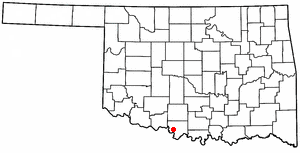
Sugden is a town in Jefferson County, Oklahoma, United States. The population was 22 as of the 2020 United States census.

<span class="mw-page-title-main">Butte Falls, Oregon</span> City in Oregon, United States

Butte Falls is a city in Jackson County, Oregon, United States. The population was 423 at the 2010 census. As of July 1, 2018, the city's population was estimated to be 450.

<span class="mw-page-title-main">Glen Lyn, Virginia</span> Town in Virginia, United States

Glen Lyn is a town in Giles County, Virginia, United States, at the confluence of the East and New rivers. The population was 115 at the 2010 census, down from 151 at the 2000 census. It is part of the Blacksburg–Christiansburg Metropolitan Statistical Area.

<span class="mw-page-title-main">Iaeger, West Virginia</span> Town in West Virginia, United States

Iaeger is a town in McDowell County, West Virginia, United States. The population was 257 at the 2020 census.

<span class="mw-page-title-main">Granville, West Virginia</span> Town in West Virginia

Granville is a town in Monongalia County, West Virginia, United States. The population was 1,355 at the 2020 census. It is included in the Morgantown metropolitan area.

<span class="mw-page-title-main">Albright, West Virginia</span> Town in West Virginia, United States

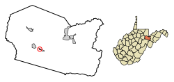
Albright is a town in central Preston County, West Virginia, United States, along the Cheat River. The population was 260 at the 2020 census. A former coal town, it is part of the Morgantown metropolitan area.

<span class="mw-page-title-main">Bruceton Mills, West Virginia</span> Town in West Virginia, United States

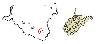
Bruceton Mills is a town in northern Preston County, West Virginia, United States, along Big Sandy Creek. The population was 64 at the 2020 census, making it the second-least populous town in West Virginia, after Thurmond. It is part of the Morgantown metropolitan area.

<span class="mw-page-title-main">Huttonsville, West Virginia</span> Town in West Virginia, United States

Huttonsville is a town in Randolph County, West Virginia, United States, along the Tygart Valley River. The population was 163 at the 2020 census.

<span class="mw-page-title-main">Cairo, West Virginia</span> Town in West Virginia, United States

Cairo is a town in Ritchie County, West Virginia, United States, along West Virginia Route 31, the North Fork of the Hughes River, and the North Bend Rail Trail. The population was 174 at the 2020 census.

<span class="mw-page-title-main">Middlebourne, West Virginia</span> Town in West Virginia, United States

Middlebourne is a town and the county seat of Tyler County, West Virginia, United States. The population was 715 at the 2020 census.

<span class="mw-page-title-main">Smithfield, West Virginia</span> Town in West Virginia, United States

Smithfield is a town in Wetzel County, West Virginia, United States. The population was 103 at the 2020 census.

<span class="mw-page-title-main">Oceana, West Virginia</span> Town in West Virginia, United States

Oceana is a town in Wyoming County, West Virginia. The population was 1,462 at the time of the 2020 census. Oceana is the oldest city in Wyoming County and was the county seat until 1907.

<span class="mw-page-title-main">Van Buren, Maine</span> Town in Maine, United States

Van Buren is a town on the Saint John River in Aroostook County, Maine, United States; located across from Saint-Leonard, New Brunswick, Canada. The population was 2,038 at the 2020 census. It is named after U.S. President Martin Van Buren.

References

  1. "2019 U.S. Gazetteer Files". United States Census Bureau. Retrieved August 7, 2020.
  2. 1 2 3 4 Bureau, US Census. "City and Town Population Totals: 2020-2021". Census.gov. US Census Bureau. Retrieved July 3, 2022.
  3. 1 2 "U.S. Census website". United States Census Bureau . Retrieved January 31, 2008.
  4. "US Board on Geographic Names". United States Geological Survey. October 25, 2007. Retrieved January 31, 2008.
  5. Kenny, Hamill (1945). West Virginia Place Names: Their Origin and Meaning, Including the Nomenclature of the Streams and Mountains. Piedmont, WV: The Place Name Press. p. 293.
  6. "US Gazetteer files: 2010, 2000, and 1990". United States Census Bureau. February 12, 2011. Retrieved April 23, 2011.
  7. "US Gazetteer files 2010". United States Census Bureau . Retrieved January 24, 2013.
  8. Climate Summary for Hambleton, West Virginia
  9. "Census of Population and Housing". Census.gov. Retrieved June 4, 2015.
  10. "U.S. Census website". United States Census Bureau . Retrieved January 24, 2013.