Smithfield, West Virginia

Last updated

Smithfield, West Virginia
Wetzel County West Virginia Incorporated and Unincorporated areas Smithfield Highlighted.svg
Location of Smithfield in Wetzel County, West Virginia.
Coordinates: 39°29′49″N80°33′40″W / 39.49694°N 80.56111°W / 39.49694; -80.56111
Country United States
State West Virginia
County Wetzel
Area
[1]
  Total0.30 sq mi (0.77 km2)
  Land0.29 sq mi (0.76 km2)
  Water0.01 sq mi (0.01 km2)
Elevation
846 ft (258 m)
Population
 (2020) [2]
  Total103
  Estimate 
(2021) [2]
101
  Density500.00/sq mi (192.88/km2)
Time zone UTC-5 (Eastern (EST))
  Summer (DST) UTC-4 (EDT)
ZIP code
26437
Area code 304
FIPS code 54-74788 [3]
GNIS feature ID1555648 [4]

Smithfield is a town in Wetzel County, West Virginia, United States. The population was 103 at the 2020 census. [2]

Contents

Smithfield was named for Henry Smith, who kept a store there. [5] [6]

Geography

Smithfield is located at 39°29′49″N80°33′40″W / 39.49694°N 80.56111°W / 39.49694; -80.56111 (39.496806, -80.561242). [7]

According to the United States Census Bureau, the town has a total area of 0.30 square miles (0.78 km2), of which 0.29 square miles (0.75 km2) is land and 0.01 square miles (0.03 km2) is water. [8]

Climate

The climate in this area is characterized by hot, humid summers and generally mild to cool winters. According to the Köppen Climate Classification system, Smithfield has a humid subtropical climate, abbreviated "Cfa" on climate maps. [9]

Demographics

Historical population
CensusPop.Note
1910 765
1920 7741.2%
1930 609−21.3%
1940 455−25.3%
1950 390−14.3%
1960 361−7.4%
1970 294−18.6%
1980 278−5.4%
1990 205−26.3%
2000 177−13.7%
2010 145−18.1%
2020 103−29.0%
2021 (est.)101 [2] −1.9%
U.S. Decennial Census [10]

2010 census

At the 2010 census there were 145 people, 63 households, and 39 families living in the town. The population density was 500.0 inhabitants per square mile (193.1/km2). There were 92 housing units at an average density of 317.2 per square mile (122.5/km2). The racial makeup of the town was 97.2% White, 0.7% Native American, and 2.1% from two or more races. [11] Of the 63 households 31.7% had children under the age of 18 living with them, 39.7% were married couples living together, 9.5% had a female householder with no husband present, 12.7% had a male householder with no wife present, and 38.1% were non-families. 36.5% of households were one person and 14.2% were one person aged 65 or older. The average household size was 2.30 and the average family size was 3.03.

The median age in the town was 44.8 years. 22.8% of residents were under the age of 18; 6.1% were between the ages of 18 and 24; 21.3% were from 25 to 44; 32.4% were from 45 to 64; and 17.2% were 65 or older. The gender makeup of the town was 47.6% male and 52.4% female.

2000 census

At the 2000 census there were 177 people, 77 households, and 49 families living in the town. The population density was 703.4 inhabitants per square mile (273.4/km2). There were 98 housing units at an average density of 389.5 per square mile (151.4/km2). The racial makeup of the town was 100.00% White. Hispanic or Latino of any race were 1.13%. [3]

Of the 77 households 23.4% had children under the age of 18 living with them, 39.0% were married couples living together, 15.6% had a female householder with no husband present, and 35.1% were non-families. 29.9% of households were one person and 16.9% were one person aged 65 or older. The average household size was 2.30 and the average family size was 2.82.

The age distribution was 19.8% under the age of 18, 11.9% from 18 to 24, 24.3% from 25 to 44, 19.8% from 45 to 64, and 24.3% 65 or older. The median age was 42 years. For every 100 females, there were 108.2 males. For every 100 females age 18 and over, there were 97.2 males.

The median household income was $78,500 and the median family income was $92,188. Males had a median income of $73,125 versus $35,000 for females. The per capita income for the town was $58,279. About 1.8% of families and 2.9% of the population were below the poverty line, including 43.9% of those under the age of eighteen and 13.2% of those sixty five or over.

Related Research Articles

<span class="mw-page-title-main">Smithfield, Kentucky</span> City in Kentucky, United States

Smithfield is a home rule-class city in Henry County, Kentucky, United States. The population was 106 at the 2010 census. The mayor of Smithfield is Greg Gephart.

<span class="mw-page-title-main">Masardis, Maine</span> Town in Maine, United States

Masardis is a town in Aroostook County, Maine, United States. The population was 204 at the 2020 census.

<span class="mw-page-title-main">Hartford, Maine</span> Town in the state of Maine, United States

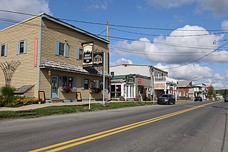
Hartford is a town in Oxford County, Maine, United States. Hartford is included in the Lewiston-Auburn, Maine metropolitan New England City and Town Area. The population was 1,203 at the 2020 census.

Springfield is a town in Penobscot County, Maine, United States. The population was 293 at the 2020 census.

<span class="mw-page-title-main">Smithfield, Maine</span> Town in the state of Maine, United States

Smithfield is a town in Somerset County, Maine, United States. The population was 925 at the 2020 census. The town was incorporated on February 29, 1840, making it the only town in Maine incorporated on Leap Day. The town was named after the Rev. Henry Smith, an early settler.

<span class="mw-page-title-main">Smithfield Township, Bradford County, Pennsylvania</span> Township in Pennsylvania, United States

Smithfield Township is a township in Bradford County, Pennsylvania, United States. It is part of Northeastern Pennsylvania. The population was 1,498 at the 2010 census.

<span class="mw-page-title-main">Smithfield, Pennsylvania</span> Borough in Pennsylvania, United States

Smithfield is a borough in Fayette County, Pennsylvania, United States. The population was 830 at the 2020 census. It is served by the Albert Gallatin Area School District. The town's largest employer is a small wire producing plant run by Nelson Steel.

<span class="mw-page-title-main">Union Township, Lebanon County, Pennsylvania</span> Township in Pennsylvania, United States

Union Township is a township in Lebanon County, Pennsylvania, United States. It is part of the Lebanon, Pennsylvania metropolitan statistical area. The population was 2,925 at the 2020 census.

<span class="mw-page-title-main">Belington, West Virginia</span> City in West Virginia

Belington is a town in Barbour County, West Virginia, United States, situated along the Tygart Valley River. The population was 1,804 as of the 2020 census.

<span class="mw-page-title-main">McMechen, West Virginia</span> City in West Virginia

McMechen is a city in Marshall County, West Virginia, United States, situated along the Ohio River. It is part of the Wheeling, West Virginia Metropolitan Statistical Area. The population was 1,714 at the 2020 census.

<span class="mw-page-title-main">Granville, West Virginia</span> Town in West Virginia

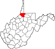
Granville is a town in Monongalia County, West Virginia, United States. The population was 1,355 at the 2020 census. It is included in the Morgantown metropolitan area.

<span class="mw-page-title-main">Bruceton Mills, West Virginia</span> Town in West Virginia, United States

Bruceton Mills is a town in northern Preston County, West Virginia, United States, along Big Sandy Creek. The population was 64 at the 2020 census, making it the second-least populous town in West Virginia, after Thurmond. It is part of the Morgantown metropolitan area.

<span class="mw-page-title-main">Rowlesburg, West Virginia</span> Town in West Virginia, United States

Rowlesburg is a town in southern Preston County, West Virginia, United States, along the Cheat River. The population was 438 at the 2020 census. It is part of the Morgantown metropolitan area. A former railroad town, it is home to the Downtown Rowlesburg Historic District, and was the site of action during the American Civil War.

<span class="mw-page-title-main">Cairo, West Virginia</span> Town in West Virginia, United States

Cairo is a town in Ritchie County, West Virginia, United States, along West Virginia Route 31, the North Fork of the Hughes River, and the North Bend Rail Trail. The population was 174 at the 2020 census.

<span class="mw-page-title-main">Davis, West Virginia</span> Town in West Virginia, United States

Davis is a town in Tucker County, West Virginia, United States, situated along the Blackwater River. The population was 595 at the 2020 census.

<span class="mw-page-title-main">Hambleton, West Virginia</span> Town in West Virginia, United States

Hambleton is a town in Tucker County, West Virginia, United States. The population was 216 at the 2020 census. Hambleton was established in 1889, but not incorporated until 1905. It was named by then United States Senator Stephen B. Elkins in honor of a stockholder by this name in the West Virginia Central Railroad Company. The town was previously known as Hulings.

<span class="mw-page-title-main">Middlebourne, West Virginia</span> Town in West Virginia, United States

Middlebourne is a town and the county seat of Tyler County, West Virginia, United States. The population was 715 at the 2020 census.

<span class="mw-page-title-main">Elizabeth, West Virginia</span> Town in West Virginia, United States

Elizabeth is a town in and the county seat of Wirt County, West Virginia, United States, situated along the Little Kanawha River. The population was 724 as of the 2020 census.

<span class="mw-page-title-main">Maiden Rock, Wisconsin</span> Village in Wisconsin, United States

Maiden Rock is a village in Pierce County, Wisconsin, United States. The population was 119 at the 2010 census. The village is located within the Town of Maiden Rock.

<span class="mw-page-title-main">Rudolph, Wisconsin</span> Village in Wisconsin, United States

Rudolph is a village in Wood County, Wisconsin, United States. The population was 439 at the 2010 census. The village is located within the Town of Rudolph.

References

  1. "2019 U.S. Gazetteer Files". United States Census Bureau. Retrieved August 7, 2020.
  2. 1 2 3 4 "City and Town Population Totals: 2020-2021". Census.gov. US Census Bureau. Retrieved July 2, 2022.
  3. 1 2 "U.S. Census website". United States Census Bureau . Retrieved January 31, 2008.
  4. "US Board on Geographic Names". United States Geological Survey. October 25, 2007. Retrieved January 31, 2008.
  5. Capace, Nancy (1999). Encyclopedia of West Virginia. North American Book Dist LLC. p. 191. ISBN   978-0-403-09843-9.
  6. Kenny, Hamill (1945). West Virginia Place Names: Their Origin and Meaning, Including the Nomenclature of the Streams and Mountains. Piedmont, WV: The Place Name Press. p. 588.
  7. "US Gazetteer files: 2010, 2000, and 1990". United States Census Bureau. February 12, 2011. Retrieved April 23, 2011.
  8. "US Gazetteer files 2010". United States Census Bureau. Archived from the original on January 25, 2012. Retrieved January 24, 2013.
  9. Climate Summary for Smithfield, West Virginia
  10. "Census of Population and Housing". Census.gov. Retrieved June 4, 2015.
  11. "U.S. Census website". United States Census Bureau . Retrieved January 24, 2013.