White Hall, West Virginia

Last updated

White Hall, West Virginia
Flag of White Hall, West Virginia.svg
Marion County West Virginia Incorporated and Unincorporated areas White Hall Highlighted.svg
Location of White Hall in Marion County, West Virginia.
Coordinates: 39°25′34″N80°11′1″W / 39.42611°N 80.18361°W / 39.42611; -80.18361
Country United States
State West Virginia
County Marion
Area
[1]
  Total1.05 sq mi (2.73 km2)
  Land1.05 sq mi (2.73 km2)
  Water0.00 sq mi (0.00 km2)
Elevation
1,158 ft (353 m)
Population
 (2020) [2]
  Total706
  Estimate 
(2021) [2]
705
  Density633.08/sq mi (244.35/km2)
Time zone UTC-5 (Eastern (EST))
  Summer (DST) UTC-4 (EDT)
ZIP codes
26554-26555
Area code 304
FIPS code 54-86620 [3]
GNIS feature ID1555973 [4]
Website www.townofwhitehallwv.org

White Hall is a town in Marion County, West Virginia, United States. The population was 706 at the 2020 census. [2] Incorporated in 1989, White Hall is adjacent to the county seat, Fairmont, and is part of the Fairmont, West Virginia, Micropolitan Statistical Area. White Hall has many different stores and restaurants.

Contents

Geography

White Hall is located at 39°25′34″N80°11′1″W / 39.42611°N 80.18361°W / 39.42611; -80.18361 (39.426223, -80.183541). [5]

According to the United States Census Bureau, the town has a total area of 1.05 square miles (2.72 km2), all land. [6]

Demographics

Historical population
CensusPop.Note
2000 595
2010 6488.9%
2020 7069.0%
2021 (est.)705 [2] −0.1%
U.S. Decennial Census [7]

2010 census

At the 2010 census there were 648 people, 299 households, and 178 families living in the town. The population density was 617.1 inhabitants per square mile (238.3/km2). There were 313 housing units at an average density of 298.1 per square mile (115.1/km2). The racial makeup of the town was 91.5% White, 2.5% African American, 0.2% Native American, 3.1% Asian, 0.3% from other races, and 2.5% from two or more races. Hispanic or Latino of any race were 1.9%. [8]

Of the 299 households 20.7% had children under the age of 18 living with them, 46.2% were married couples living together, 10.7% had a female householder with no husband present, 2.7% had a male householder with no wife present, and 40.5% were non-families. 32.8% of households were one person and 9.7% were one person aged 65 or older. The average household size was 2.17 and the average family size was 2.78.

The median age in the town was 40.9 years. 17.9% of residents were under the age of 18; 10.3% were between the ages of 18 and 24; 26.4% were from 25 to 44; 29.8% were from 45 to 64; and 15.6% were 65 or older. The gender makeup of the town was 48.5% male and 51.5% female.

2000 census

At the 2000 census there were 595 people, 262 households, and 161 families living in the town. The population density was 624.7 inhabitants per square mile (241.8/km2). There were 295 housing units at an average density of 309.7 per square mile (119.9/km2). The racial makeup of the town was 93.61% White, 2.18% African American, 2.18% Asian, 1.18% from other races, and 0.84% from two or more races. Hispanic or Latino of any race were 2.18%. [3]

Of the 262 households 26.3% had children under the age of 18 living with them, 48.5% were married couples living together, 9.2% had a female householder with no husband present, and 38.5% were non-families. 32.1% of households were one person and 9.2% were one person aged 65 or older. The average household size was 2.27 and the average family size was 2.90.

The age distribution was 18.7% under the age of 18, 13.6% from 18 to 24, 32.3% from 25 to 44, 22.9% from 45 to 64, and 12.6% 65 or older. The median age was 35 years. For every 100 females there were 91.3 males. For every 100 females age 18 and over, there were 92.8 males.

The median household income was $412,813 and the median family income was $501,625. Males had a median income of $391,286 versus $291,722 for females. The per capita income for the town was $211,188. About 11.2% of families and 14.9% of the population were below the poverty line, including 25.0% of those under age 18 and 3.0% of those age 65 or over.

Related Research Articles

<span class="mw-page-title-main">Bancroft, Maine</span> Unorganized territory in Maine, United States

Bancroft is a township in Aroostook County, Maine, United States. The population was 57 at the 2020 census. On July 1, 2015 the town voted to deorganize and become part of the unorganized territory of South Aroostook.

<span class="mw-page-title-main">St. Francis, Maine</span> Town in the state of Maine, United States

St. Francis is a town in Aroostook County, Maine, United States on the Canada–United States border at the junction of the St. Francis River and the Saint John River. The population was 438 at the 2020 census. First settled by English speakers from southern Maine, the original population has been supplanted by French-speaking Acadians.

<span class="mw-page-title-main">Westfield, Maine</span> Town in the state of Maine, United States

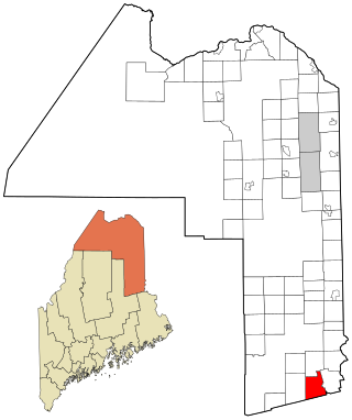
Westfield is a town in Aroostook County, Maine, United States. The population was 455 at the 2020 census.

<span class="mw-page-title-main">Hartford, Maine</span> Town in the state of Maine, United States

Hartford is a town in Oxford County, Maine, United States. Hartford is included in the Lewiston-Auburn, Maine metropolitan New England City and Town Area. The population was 1,203 at the 2020 census.

Lowell is a town in Penobscot County, Maine, United States. The population was 368 at the 2020 census.

Winn is a town in Penobscot County, Maine, United States, on the east bank of the Penobscot River. The town was named for John M. Winn, an early landholder. The population was 399 at the 2020 census.

<span class="mw-page-title-main">Smithfield, Maine</span> Town in the state of Maine, United States

Smithfield is a town in Somerset County, Maine, United States. The population was 925 at the 2020 census. The town was incorporated on February 29, 1840, making it the only town in Maine incorporated on Leap Day. The town was named after the Rev. Henry Smith, an early settler.

<span class="mw-page-title-main">Norton Center, Massachusetts</span> Census-designated place in Massachusetts, United States

Norton Center is a census-designated place (CDP) in the town of Norton in Bristol County, Massachusetts, United States. The population was 2,671 at the 2010 census.

<span class="mw-page-title-main">Harford, New York</span> Town in New York, United States

Harford is a town in Cortland County, New York, United States. The population was 943 at the 2010 census. Harford is in the southwestern corner of Cortland County and is south of Cortland.

Schlusser is a census-designated place (CDP) in North Middleton and Middlesex townships, Cumberland County, Pennsylvania, United States. The population was 5,265 at the 2010 census. It is part of the Harrisburg–Carlisle Metropolitan Statistical Area.

<span class="mw-page-title-main">Powells Crossroads, Tennessee</span> Town in Tennessee, United States

Powells Crossroads is a town in Marion County, Tennessee, United States. The population was 1,322 at the 2010 census, up from 1,286 in 2000. It is part of the Chattanooga, TN-GA Metropolitan Statistical Area.

<span class="mw-page-title-main">Chula Vista, Maverick County, Texas</span> CDP in Texas, United States

Chula Vista, formerly known as Rosita North, is a census-designated place (CDP) in Maverick County, Texas, United States. The population was 3,400 at the 2000 census.

<span class="mw-page-title-main">New Haven, West Virginia</span> Town in West Virginia, United States

New Haven is a town in Mason County, West Virginia, United States, along the Ohio River. The population was 1,485 at the 2020 census. It is part of the Point Pleasant, WV–OH Micropolitan Statistical Area.

<span class="mw-page-title-main">Anawalt, West Virginia</span> Town in West Virginia, United States

Anawalt is a town in McDowell County, West Virginia, United States. At one time it was known as Jeanette. It is named in honor of James White Anawalt, who was then manager of Union Supply Company, a subsidiary of the United States Steel Company. The population was 186 at the 2020 census. Coal mining was the town's chief industry.

<span class="mw-page-title-main">Northfork, West Virginia</span> Town in West Virginia, United States

Northfork is a town in McDowell County, West Virginia, United States, located on U.S. Route 52 between Welch and Bluefield.

<span class="mw-page-title-main">Peterstown, West Virginia</span> Town in West Virginia, United States

Peterstown is a town in Monroe County, West Virginia, United States. The population was 456 at the 2020 census.

<span class="mw-page-title-main">Newburg, West Virginia</span> Town in West Virginia, United States

Newburg is a town in western Preston County, West Virginia, United States. The population was 275 at the 2020 census. It is part of the Morgantown metropolitan area.

<span class="mw-page-title-main">Bancroft, West Virginia</span> Town in West Virginia, United States

Bancroft is a town in Putnam County, West Virginia, United States, along the Kanawha River. The population was 389 at the 2020 census. It is part of the Huntington–Ashland metropolitan area.

<span class="mw-page-title-main">Mabscott, West Virginia</span> Town in West Virginia, United States

Mabscott is a town in Raleigh County, West Virginia, United States. The population was 1,333 at the 2020 census. The town's name is a contraction of the name Mabel Scott, wife of local coal operator Cyrus H. Scott.

<span class="mw-page-title-main">Waterloo, Wisconsin</span> City in Wisconsin, United States

Waterloo is a city in Jefferson County in the U.S. state of Wisconsin. As of the census of 2022, the population was 3,628. The name Waterloo was suggested by Mr. Wilt, a Frenchman living here, who was one of Napoleon's soldiers, at the battle of Waterloo. Waterloo is located in the Watertown-Fort Atkinson micropolitan area which is a sub-market of the larger Milwaukee-Racine-Waukesha CSA.

References

  1. "2019 U.S. Gazetteer Files". United States Census Bureau. Retrieved August 7, 2020.
  2. 1 2 3 4 Bureau, US Census. "City and Town Population Totals: 2020-2021". Census.gov. US Census Bureau. Retrieved July 3, 2022.
  3. 1 2 "U.S. Census website". United States Census Bureau . Retrieved January 31, 2008.
  4. "US Board on Geographic Names". United States Geological Survey. October 25, 2007. Retrieved January 31, 2008.
  5. "US Gazetteer files: 2010, 2000, and 1990". United States Census Bureau. February 12, 2011. Retrieved April 23, 2011.
  6. "US Gazetteer files 2010". United States Census Bureau . Retrieved January 24, 2013.
  7. "Census of Population and Housing". Census.gov. Retrieved June 4, 2015.
  8. "U.S. Census website". United States Census Bureau . Retrieved January 24, 2013.