Worthington, West Virginia

Last updated

Worthington, West Virginia
Worthington West Virginia.jpg
Main Street (Route 19) in Worthington in 2006
Marion County West Virginia Incorporated and Unincorporated areas Worthington Highlighted.svg
Location of Worthington in Marion County, West Virginia.
Coordinates: 39°27′6″N80°15′46″W / 39.45167°N 80.26278°W / 39.45167; -80.26278
Country United States
State West Virginia
County Marion
Area
[1]
  Total0.60 sq mi (1.55 km2)
  Land0.58 sq mi (1.51 km2)
  Water0.01 sq mi (0.04 km2)
Elevation
922 ft (281 m)
Population
 (2020) [2]
  Total183
  Estimate 
(2021) [2]
182
  Density253.86/sq mi (98.02/km2)
Time zone UTC-5 (Eastern (EST))
  Summer (DST) UTC-4 (EDT)
ZIP code
26591
Area code 304
FIPS code 54-88708 [3]
GNIS feature ID1556026 [4]
Website local.wv.gov/worthington/Pages/default.aspx
The West Fork River in Worthington in 2006 West Fork River Worthington.jpg
The West Fork River in Worthington in 2006

Worthington is a town in Marion County, West Virginia, United States. The population was 158 at the 2010 census. Worthington was incorporated in 1893 and named for Colonel George Worthington, an early settler. [5] U.S. Route 19 passes through the town.

Contents

Geography

Worthington is located at 39°27′6″N80°15′46″W / 39.45167°N 80.26278°W / 39.45167; -80.26278 (39.451617, -80.262755), [6] along the West Fork River. [7]

According to the United States Census Bureau, the town has a total area of 0.60 square miles (1.55 km2), of which 0.58 square miles (1.50 km2) is land and 0.02 square miles (0.05 km2) is water. [8]

Demographics

Historical population
CensusPop.Note
1860 120
1870 1275.8%
1880 87−31.5%
1910 292
1920 38130.5%
1930 4056.3%
1940 50725.2%
1950 5447.3%
1960 361−33.6%
1970 288−20.2%
1980 32914.2%
1990 233−29.2%
2000 170−27.0%
2010 158−7.1%
2020 18315.8%
2021 (est.)182 [2] −0.5%
U.S. Decennial Census [9]

2010 census

As of the census [10] of 2010, there were 158 people, 67 households, and 47 families living in the town. The population density was 272.4 inhabitants per square mile (105.2/km2). There were 82 housing units at an average density of 141.4 per square mile (54.6/km2). The racial makeup of the town was 98.1% White and 1.9% from two or more races. Hispanic or Latino of any race were 2.5% of the population.

There were 67 households, of which 26.9% had children under the age of 18 living with them, 52.2% were married couples living together, 10.4% had a female householder with no husband present, 7.5% had a male householder with no wife present, and 29.9% were non-families. 26.9% of all households were made up of individuals, and 10.5% had someone living alone who was 65 years of age or older. The average household size was 2.36 and the average family size was 2.83.

The median age in the town was 42 years. 19.6% of residents were under the age of 18; 7% were between the ages of 18 and 24; 28.5% were from 25 to 44; 30.4% were from 45 to 64; and 14.6% were 65 years of age or older. The gender makeup of the town was 48.1% male and 51.9% female.

2000 census

As of the census [3] of 2000, there were 170 people, 76 households, and 48 families living in the town. The population density was 296.2 inhabitants per square mile (115.2/km2). There were 93 housing units at an average density of 162.0 per square mile (63.0/km2). The racial makeup of the town was 99.41% White, and 0.59% from two or more races.

There were 76 households, out of which 22.4% had children under the age of 18 living with them, 53.9% were married couples living together, 5.3% had a female householder with no husband present, and 36.8% were non-families. 32.9% of all households were made up of individuals, and 25.0% had someone living alone who was 65 years of age or older. The average household size was 2.24 and the average family size was 2.83.

In the town, the population was spread out, with 19.4% under the age of 18, 7.6% from 18 to 24, 32.9% from 25 to 44, 20.0% from 45 to 64, and 20.0% who were 65 years of age or older. The median age was 41 years. For every 100 females, there were 97.7 males. For every 100 females age 18 and over, there were 90.3 males.

The median income for a household in the town was $28,750, and the median income for a family was $35,417. Males had a median income of $24,750 versus $23,750 for females. The per capita income for the town was $14,490. About 10.2% of families and 15.0% of the population were below the poverty line, including 26.3% of those under the age of eighteen and none of those 65 or over.

Related Research Articles

<span class="mw-page-title-main">Morgan County, Alabama</span> County in Alabama, United States

Morgan County is a county in the north-central part of the U.S. state of Alabama. As of the 2020 census, its population was 123,421. The county seat is Decatur. On June 14, 1821, it was renamed in honor of American Revolutionary War General Daniel Morgan of Virginia. It is a prohibition or dry county, although alcohol sales are allowed in the cities of Decatur, Hartselle, and Priceville. Morgan County is included in the Decatur, AL Metropolitan Statistical Area, which is also included in the Huntsville-Decatur-Albertville, AL Combined Statistical Area. It is a part of the North, Northwest, and North-Central regions of Alabama.

<span class="mw-page-title-main">Nikiski, Alaska</span> Census-designated place in Alaska, United States

Nikiski is a census-designated place (CDP) in Kenai Peninsula Borough, Alaska, United States. The population was 4,456 at the 2020 census, down from 4,493 in 2010.

<span class="mw-page-title-main">Worthington, Indiana</span> Town in Indiana, United States

Worthington is a town in Jefferson Township, Greene County, Indiana, United States. The population was 1,463 at the 2010 United States Census. It is part of the Bloomington, Indiana, Metropolitan Statistical Area.

<span class="mw-page-title-main">Poneto, Indiana</span> Town in Indiana, United States

Poneto is a town in Chester, Harrison and Liberty townships, Wells County, in the U.S. state of Indiana. The population was 166 at the 2010 census.

<span class="mw-page-title-main">Worthington, Iowa</span> City in Iowa, United States

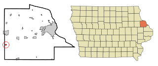
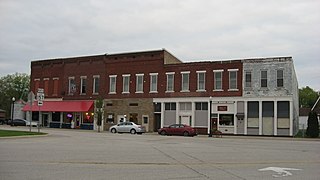
Worthington is a city in Dubuque County, Iowa, United States. The population was 382 at the time of the 2020 census, up from 381 in 2000. Iowa Highway 136 passes through Worthington, which is situated north of Cascade and south of Dyersville.

<span class="mw-page-title-main">Dayton, Iowa</span> City in Iowa, United States

Dayton is a city in Webster County, Iowa, United States. The population was 772 at the time of the 2020 census.

<span class="mw-page-title-main">Worthington Hills, Kentucky</span> City in Kentucky, United States

City of Worthington Hills is a home rule-class city in Jefferson County, Kentucky, United States. The population was 1,446 at the 2010 census, down from 1,594 at the 2000 census.

<span class="mw-page-title-main">Worthington, Missouri</span> Village in Missouri, United States

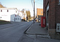
Worthington is a village in southeast Putnam County, Missouri, United States. The population was 47 at the 2020 census.

Naytahwaush is a census-designated place (CDP) in Mahnomen County, Minnesota, United States. The population was 504 at the 2020 census.

<span class="mw-page-title-main">Riverlea, Ohio</span> Village in Ohio, United States

Riverlea is a village in Franklin County, Ohio, United States, surrounded by Worthington on its north, south, and east sides, and bordered on the west by the Olentangy River, across which is Columbus. Riverlea was incorporated in 1939, a small community that formed on former farmland. The population was 599 at the 2020 census.

<span class="mw-page-title-main">Coronaca, South Carolina</span> Census-designated place in South Carolina, United States

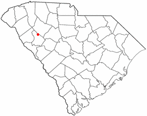
Coronaca is an unincorporated community and census-designated place (CDP) in Greenwood County, South Carolina, United States. The population was 191 at the 2010 census.

<span class="mw-page-title-main">Cuevitas, Texas</span> Census-designated place in Texas

Cuevitas is a census-designated place (CDP) in Hidalgo County, Texas, United States. The population was 40 at the 2010 United States Census. Rated the poorest community in Texas, it is part of the McAllen–Edinburg–Mission Metropolitan Statistical Area.

<span class="mw-page-title-main">Newburg, West Virginia</span> Town in West Virginia, United States

Newburg is a town in western Preston County, West Virginia, United States. The population was 275 at the 2020 census. It is part of the Morgantown metropolitan area.

<span class="mw-page-title-main">Bancroft, West Virginia</span> Town in West Virginia, United States

Bancroft is a town in Putnam County, West Virginia, United States, along the Kanawha River. The population was 389 at the 2020 census. It is part of the Huntington–Ashland metropolitan area.

<span class="mw-page-title-main">Reedy, West Virginia</span> Town in West Virginia, United States

Reedy is a town in Roane County, West Virginia, United States. The population was 152 at the 2020 census.

<span class="mw-page-title-main">Camden-on-Gauley, West Virginia</span> Town in West Virginia, United States

Camden-on-Gauley is a town in Webster County, West Virginia, United States, along the Gauley River. The population was 126 at the 2020 census.

<span class="mw-page-title-main">Pine Grove, West Virginia</span> Town in West Virginia, United States

Pine Grove is a town in Wetzel County, West Virginia, United States. The population was 363 at the 2020 census. The community was named for a grove of pine trees near the original town site.

<span class="mw-page-title-main">Twin Lakes, Wisconsin</span> Village in Wisconsin, United States

Twin Lakes is a village in Kenosha County, Wisconsin, United States, along the Illinois-Wisconsin border east of U.S. Highway 12, incorporated in 1937. With nearly 1000 acres of surface water, the twin lakes of Mary and Elizabeth have drawn vacationers to numerous resorts as well as ice harvesters in the days of icebox refrigeration. Today, many houses there are used for recreation, and the lakes remain a popular destination. Twin Lakes is home to about 6,041 permanent residents and a third more occasional ones.

Linden is a town in Iowa County, Wisconsin, United States. The population was 873 at the 2000 census. The Village of Linden is located within the town. The unincorporated community of Edmund is located in the town.

<span class="mw-page-title-main">Gold Canyon, Arizona</span> Census-designated place in Arizona, United States

Gold Canyon is a census-designated place (CDP) and unincorporated community in Pinal County, Arizona, United States. The community is sometimes incorrectly called Gold Camp.

References

  1. "2019 U.S. Gazetteer Files". United States Census Bureau. Retrieved August 7, 2020.
  2. 1 2 3 Bureau, US Census. "City and Town Population Totals: 2020-2021". Census.gov. US Census Bureau. Retrieved July 3, 2022.
  3. 1 2 "U.S. Census website". United States Census Bureau . Retrieved January 31, 2008.
  4. "US Board on Geographic Names". United States Geological Survey. October 25, 2007. Retrieved January 31, 2008.
  5. West Virginia Blue Book. Published annually by the Clerk's Office of the West Virginia Senate.
  6. "US Gazetteer files: 2010, 2000, and 1990". United States Census Bureau. February 12, 2011. Retrieved April 23, 2011.
  7. West Virginia Atlas & Gazetteer. Yarmouth, Me.: DeLorme. 1997. p. 25. ISBN   0-89933-246-3.
  8. "US Gazetteer files 2010". United States Census Bureau . Retrieved January 24, 2013.
  9. "Census of Population and Housing". Census.gov. Retrieved June 4, 2015.
  10. "U.S. Census website". United States Census Bureau . Retrieved January 24, 2013.