Quinwood, West Virginia

Last updated

Quinwood, West Virginia
B^M Grocery of Quinwood, West Virginia - panoramio.jpg
B&M Grocery, central Quinwood
Greenbrier County West Virginia Incorporated and Unincorporated areas Quinwood Highlighted.svg
Location of Quinwood in Greenbrier County, West Virginia.
Coordinates: 38°03′31″N80°42′21″W / 38.05861°N 80.70583°W / 38.05861; -80.70583
Country United States
State West Virginia
County Greenbrier
Area
[1]
  Total0.35 sq mi (0.90 km2)
  Land0.35 sq mi (0.90 km2)
  Water0.00 sq mi (0.00 km2)
Elevation
[2]
3,048 ft (929 m)
Population
 (2020) [3]
  Total220
  Estimate 
(2021) [3]
217
  Density760.12/sq mi (293.85/km2)
Time zone UTC-5 (Eastern (EST))
  Summer (DST) UTC-4 (EDT)
ZIP code
25981
Area code 304
FIPS code 54-66412 [4]
GNIS feature ID2391380 [2]

Quinwood is a town and former coal town in Greenbrier County, West Virginia, United States. The population was 220 at the 2020 census. [3]

Contents

The community's name is an amalgamation of the names of its proprietors Quin Morton and W. S. Wood. [5]

Geography

Quinwood is located at 38°3′29″N80°42′16″W / 38.05806°N 80.70444°W / 38.05806; -80.70444 (38.058117, -80.704334). [6]

According to the United States Census Bureau, the town has a total area of 0.35 square miles (0.91 km2), all land. [7]

Demographics

Historical population
CensusPop.Note
1950 838
1960 506−39.6%
1970 370−26.9%
1980 46024.3%
1990 55921.5%
2000 435−22.2%
2010 290−33.3%
2020 220−24.1%
2021 (est.)217 [3] −1.4%
U.S. Decennial Census [8]

2010 census

At the 2010 census there were 290 people, 118 households, and 92 families living in the town. The population density was 828.6 inhabitants per square mile (319.9/km2). There were 152 housing units at an average density of 434.3 per square mile (167.7/km2). The racial makeup of the town was 95.5% White, 1.0% African American, 0.7% Native American, 0.3% from other races, and 2.4% from two or more races. Hispanic or Latino of any race were 0.3%. [9]

Of the 118 households 31.4% had children under the age of 18 living with them, 58.5% were married couples living together, 15.3% had a female householder with no husband present, 4.2% had a male householder with no wife present, and 22.0% were non-families. 17.8% of households were one person and 6.7% were one person aged 65 or older. The average household size was 2.46 and the average family size was 2.66.

The median age in the town was 47 years. 18.3% of residents were under the age of 18; 8.2% were between the ages of 18 and 24; 21.5% were from 25 to 44; 32.5% were from 45 to 64; and 19.7% were 65 or older. The gender makeup of the town was 52.4% male and 47.6% female.

2000 census

At the 2000 census there were 435 people, 169 households, and 126 families living in the town. The population density was 883.1 inhabitants per square mile (342.8/km2). There were 193 housing units at an average density of 391.8 per square mile (152.1/km2). The racial makeup of the town was 95.40% White, 2.53% African American, 0.23% Native American, and 1.84% from two or more races. Hispanic or Latino of any race were 0.92%. [4]

Of the 169 households 33.1% had children under the age of 18 living with them, 59.8% were married couples living together, 11.8% had a female householder with no husband present, and 24.9% were non-families. 21.3% of households were one person and 9.5% were one person aged 65 or older. The average household size was 2.57 and the average family size was 2.98.

The age distribution was 23.9% under the age of 18, 7.6% from 18 to 24, 26.2% from 25 to 44, 23.2% from 45 to 64, and 19.1% 65 or older. The median age was 40 years. For every 100 females, there were 92.5 males. For every 100 females age 18 and over, there were 89.1 males.

The median household income was $21,705 and the median family income was $24,196. Males had a median income of $25,179 versus $19,250 for females. The per capita income for the town was $11,911. About 22.9% of families and 26.9% of the population were below the poverty line, including 41.0% of those under age 18 and 18.2% of those age 65 or over.

Climate

With the elevation and location on a western facing slope, Quinwood can easily see significant amounts of snowfall when winds from the northwest carry moisture from the great lakes and ride up the mountains. This event is called orographic lift. Snowfall amounts over one foot are very common during these events. In 2012, Hurricane Sandy left 29 inches (74 cm) of snow in Quinwood. [10]

Quinwood has a humid continental climate (Köppen Dfb), bordering on a subtropical highland climate (Köppen Cfb). Due to its higher elevation, Quinwood experiences harsher winters and milder summers in comparison to the nearby cities of Lewisburg and White Sulpher Springs.

Climate data for Quinwood, West Virginia, 1991–2020 normals, 1989-2020 extremes: 3319ft (1012m)
MonthJanFebMarAprMayJunJulAugSepOctNovDecYear
Record high °F (°C)67
(19)
71
(22)
81
(27)
83
(28)
89
(32)
88
(31)
94
(34)
91
(33)
89
(32)
86
(30)
76
(24)
70
(21)
94
(34)
Mean maximum °F (°C)56.0
(13.3)
59.6
(15.3)
68.8
(20.4)
78.3
(25.7)
81.9
(27.7)
83.1
(28.4)
84.9
(29.4)
84.5
(29.2)
82.7
(28.2)
76.3
(24.6)
67.7
(19.8)
56.7
(13.7)
86.4
(30.2)
Mean daily maximum °F (°C)34.2
(1.2)
37.8
(3.2)
46.4
(8.0)
58.7
(14.8)
67.1
(19.5)
73.1
(22.8)
76.6
(24.8)
75.9
(24.4)
70.5
(21.4)
60.0
(15.6)
47.8
(8.8)
38.1
(3.4)
57.2
(14.0)
Daily mean °F (°C)26.4
(−3.1)
29.2
(−1.6)
37.4
(3.0)
48.4
(9.1)
56.9
(13.8)
63.8
(17.7)
67.3
(19.6)
66.6
(19.2)
60.9
(16.1)
50.1
(10.1)
39.2
(4.0)
30.7
(−0.7)
48.1
(8.9)
Mean daily minimum °F (°C)18.6
(−7.4)
20.6
(−6.3)
28.3
(−2.1)
38.0
(3.3)
46.8
(8.2)
54.5
(12.5)
58.1
(14.5)
57.4
(14.1)
51.3
(10.7)
40.2
(4.6)
30.5
(−0.8)
23.3
(−4.8)
39.0
(3.9)
Mean minimum °F (°C)−2.3
(−19.1)
1.8
(−16.8)
8.0
(−13.3)
19.6
(−6.9)
31.3
(−0.4)
42.8
(6.0)
48.9
(9.4)
47.6
(8.7)
37.0
(2.8)
24.2
(−4.3)
12.9
(−10.6)
5.4
(−14.8)
−5.9
(−21.1)
Record low °F (°C)−25
(−32)
−14
(−26)
−3
(−19)
9
(−13)
21
(−6)
33
(1)
44
(7)
40
(4)
27
(−3)
15
(−9)
0
(−18)
−12
(−24)
−25
(−32)
Average precipitation inches (mm)4.09
(104)
4.02
(102)
5.09
(129)
4.43
(113)
5.58
(142)
4.78
(121)
5.41
(137)
4.18
(106)
3.92
(100)
3.14
(80)
3.98
(101)
4.72
(120)
53.34
(1,355)
Average snowfall inches (cm)22.7
(58)
21.9
(56)
14.1
(36)
3.4
(8.6)
0.0
(0.0)
0.0
(0.0)
trace0.0
(0.0)
0.0
(0.0)
1.3
(3.3)
4.7
(12)
17.3
(44)
85.4
(217.9)
Source 1: NOAA [11]
Source 2: XMACIS (snowfall, temp records & monthly max/mins) [12]

Notable person

Quinwood was the birthplace of Ralph E. Pomeroy, who received the Medal of Honor for his actions during the Korean War.

Related Research Articles

<span class="mw-page-title-main">Sylvania, Alabama</span> Town in Alabama, United States

Sylvania is a town in DeKalb County, Alabama, United States. It incorporated in October 1967. At the 2010 census the population was 1,837, up from 1,186 in 2000. Sylvania is located atop Sand Mountain. Sylvania was incorporated in 1967. The post office /town hall was built in 1977.

<span class="mw-page-title-main">Littleton, Maine</span> Town in the state of Maine, United States

Littleton is a town in Aroostook County, Maine, United States. The population was 997 at the 2020 census.

<span class="mw-page-title-main">Perham, Maine</span> Town in the state of Maine, United States

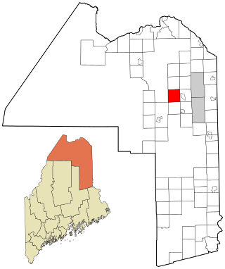
Perham is a town in Aroostook County, Maine, United States. The population was 371 at the 2020 census. The town was named after Maine's 33rd governor, Sidney Perham.

<span class="mw-page-title-main">Wade, Maine</span> Town in the state of Maine, United States

Wade is a town in Aroostook County, Maine, United States. The population was 229 at the 2020 census.

<span class="mw-page-title-main">Benton, Maine</span> Town in the state of Maine, United States

Benton is a town in Kennebec County, Maine, United States. It was formed in 1842, as a subdivision of the town of Clinton. The population was 2,715 at the 2020 census. The town was named for Missouri Senator Thomas Hart Benton.

Stoneham is a town in Oxford County, Maine, United States. The population was 261 at the 2020 census.

<span class="mw-page-title-main">Upton, Maine</span> Town in the state of Maine, United States

Upton is a town in Oxford County, Maine, United States. The population was 69 at the 2020 census.

Woodstock is a town in Oxford County, Maine, United States. Woodstock is included in the Lewiston-Auburn, Maine metropolitan New England city and town area. The population was 1,352 at the 2020 census. The village of Bryant Pond, on State Route 26 in the northern part of Woodstock, is the town's urban center and largest settlement.

Plymouth is a town in Penobscot County, Maine, United States. The population was 1,325 at the 2020 census.

<span class="mw-page-title-main">Trappe, Maryland</span> Town in Maryland, United States

Trappe is a town in Talbot County, Maryland, United States. The population was 1,077 at the 2010 census. It is the site of one of the largest mixed-use developments on the U.S. East Coast called Trappe East or "Lakeside" with controversy arising over its wastewater treatment.

<span class="mw-page-title-main">Orchard Homes, Montana</span> CDP in Montana, United States

Orchard Homes is a census-designated place (CDP) in Missoula County, Montana, United States. It is part of the Missoula Metropolitan Statistical Area. The population was 5,377 at the 2020 census.

Lenox is a town in Madison County, New York, United States. The population was 8,768 as of the 2020 census.

<span class="mw-page-title-main">Alba, Pennsylvania</span> Borough in Pennsylvania, United States

Alba is a borough in Bradford County, Pennsylvania, United States. It is part of Northeastern Pennsylvania. The population was 135 at the 2020 census.

<span class="mw-page-title-main">Waterloo, South Carolina</span> Town in South Carolina, United States

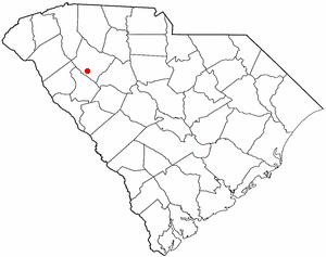
Waterloo is a town in Laurens County, South Carolina, United States. The population was 166 at the 2010 census.

<span class="mw-page-title-main">Worthington, West Virginia</span> Town in West Virginia, United States

Worthington is a town in Marion County, West Virginia, United States. The population was 158 at the 2010 census. Worthington was incorporated in 1893 and named for Colonel George Worthington, an early settler. U.S. Route 19 passes through the town.

<span class="mw-page-title-main">Oakvale, West Virginia</span> Town in West Virginia, United States

Oakvale is a town in Mercer County, West Virginia, United States, along the East River. The population was 137 at the 2020 census. It is part of the Bluefield, WV-VA micropolitan area which has a population of 107,578.

<span class="mw-page-title-main">Gilbert, West Virginia</span> Town in West Virginia, United States

Gilbert is a town in Mingo County, West Virginia, United States, along the Guyandotte River. The population was 333 at the 2020 census. Gilbert was incorporated in 1918 and named for Gilbert Creek, which derives its name from the name of an early traveler in the area who was killed by Native Americans. Gilbert is known nationwide for the Hatfield-McCoy ATV Trails that are located in the area. There are a number of lodges and restaurants in Gilbert.

<span class="mw-page-title-main">Albright, West Virginia</span> Town in West Virginia, United States

Albright is a town in central Preston County, West Virginia, United States, along the Cheat River. The population was 260 at the 2020 census. A former coal town, it is part of the Morgantown metropolitan area.

<span class="mw-page-title-main">Lester, West Virginia</span> Town in West Virginia, United States

Lester is a town in Raleigh County, West Virginia, United States. The population was 337 at the 2020 census. The community was named after Champ Lester, a local pioneer.

<span class="mw-page-title-main">St. Albans, Maine</span> Town in the state of Maine, United States

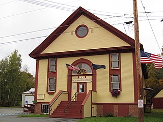
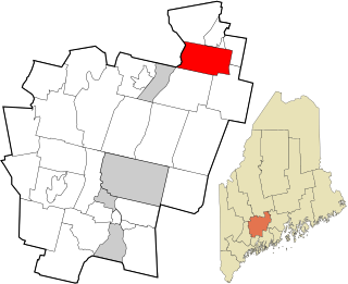
St. Albans is a town in Somerset County, Maine, United States. The population was 2,045 at the 2020 census.

References

  1. "2019 U.S. Gazetteer Files". United States Census Bureau. Retrieved August 7, 2020.
  2. 1 2 U.S. Geological Survey Geographic Names Information System: Quinwood, West Virginia
  3. 1 2 3 4 "City and Town Population Totals: 2020-2021". Census.gov. US Census Bureau. Retrieved July 3, 2022.
  4. 1 2 "U.S. Census website". United States Census Bureau . Retrieved January 31, 2008.
  5. Kenny, Hamill (1945). West Virginia Place Names: Their Origin and Meaning, Including the Nomenclature of the Streams and Mountains. Piedmont, WV: The Place Name Press. p. 515.
  6. "US Gazetteer files: 2010, 2000, and 1990". United States Census Bureau. February 12, 2011. Retrieved April 23, 2011.
  7. "US Gazetteer files 2010". United States Census Bureau. Archived from the original on January 12, 2012. Retrieved January 24, 2013.
  8. "Census of Population and Housing". Census.gov. Retrieved June 4, 2015.
  9. "U.S. Census website". United States Census Bureau . Retrieved January 24, 2013.
  10. "Sandy's Snowy Side Turns Deadly".
  11. "Rupert 4 N, West Virginia 1991-2020 Monthly Normals" . Retrieved December 11, 2023.
  12. "xmACIS". National Oceanic and Atmospheric Administration. Retrieved December 11, 2023.